

Difference between revisions of "Aldrich Butte-Cedar Falls Loop Hike"
From Oregon Hikers Field Guide
| Line 33: | Line 33: | ||
=== Hike Description === | === Hike Description === | ||
| − | The Cedar/Aldrich hike covers a little known section of the Gorge between [[Table Mountain]] and [[Hamilton Mountain]], near the town of North Bonneville, Washington. This may not be the grandest of excursions in the [[Columbia River Gorge]], but it is certainly one of the quietest. For those who really value solitude, this is a bit of a unknown gem in an area with a lot of interesting history. It's a long hike in here now, after the closure of the Bonneville Hot Springs Resort & Spa in January 2017 and the termination of the resort's agreement to allow part of their land as a trailhead. The only legitimate approach is from the [[Bonneville Trailhead]], a long and meandering walk over the forested terrain of the Bonneville Landslide, much of it a Pacific Crest Trail easement on private land. You will be rewarded at the end of your hike, however, with a little-visited landscape of secluded creeks, an isolated waterfall, and the | + | The Cedar/Aldrich hike covers a little known section of the Gorge between [[Table Mountain]] and [[Hamilton Mountain]], near the town of North Bonneville, Washington. This may not be the grandest of excursions in the [[Columbia River Gorge]], but it is certainly one of the quietest. For those who really value solitude, this is a bit of a unknown gem in an area with a lot of interesting history. It's a long hike in here now, after the closure of the Bonneville Hot Springs Resort & Spa in January 2017 and the termination of the resort's agreement to allow part of their land as a trailhead. The only legitimate approach is from the [[Bonneville Trailhead]], a long and meandering walk over the forested terrain of the Bonneville Landslide, much of it a Pacific Crest Trail easement on private land. You will be rewarded at the end of your hike, however, with a little-visited landscape of secluded creeks, an isolated waterfall, and the remains of the military emplacements atop [[Aldrich Butte]]. Note that trail junctions off the PCT are usually not marked, so pay close attention to the directions. |
The hike starts at the [[Bonneville Trailhead]], on the Tamanous Trail. Ta-mah-no-ous is a Native American word translated roughly as "vision quest". Young men proved their readiness to be adults by going on a search for guardian spirits. From the parking lot, you start out on a gravel road, but quickly divert up a wooded path that starts straight uphill. (Incidentally, if you continue down the gravel road another 100 yards, you'll see where the nearby train track enters a tunnel). It won't be long before you have a nice viewpoint to the south overlooking the river just east of the [[Bonneville Dam]]. There won't be much more in the way of views for a while. It is somewhere in this trail section where the trail crosses over the top of the aforementioned tunnel...but you'll be hard-pressed to see where! | The hike starts at the [[Bonneville Trailhead]], on the Tamanous Trail. Ta-mah-no-ous is a Native American word translated roughly as "vision quest". Young men proved their readiness to be adults by going on a search for guardian spirits. From the parking lot, you start out on a gravel road, but quickly divert up a wooded path that starts straight uphill. (Incidentally, if you continue down the gravel road another 100 yards, you'll see where the nearby train track enters a tunnel). It won't be long before you have a nice viewpoint to the south overlooking the river just east of the [[Bonneville Dam]]. There won't be much more in the way of views for a while. It is somewhere in this trail section where the trail crosses over the top of the aforementioned tunnel...but you'll be hard-pressed to see where! | ||
| Line 96: | Line 96: | ||
=== More Links === | === More Links === | ||
* [https://hikingnorthwest.wordpress.com/2014/09/28/aldrich-butte-hiking-history-and-a-waterfall-too/ Aldrich Butte: Hiking, History, and a Waterfall Too (Hiking Northwest)] | * [https://hikingnorthwest.wordpress.com/2014/09/28/aldrich-butte-hiking-history-and-a-waterfall-too/ Aldrich Butte: Hiking, History, and a Waterfall Too (Hiking Northwest)] | ||
| − | |||
| − | |||
Revision as of 03:29, 3 March 2017


- Start point: Bonneville Trailhead

- End point: Hamilton Creek Viewpoint
- Trail Log: Trail Log
- Hike Type: Loop / Dog bone
- Distance: 16.4 miles round trip
- High point: 1,140 feet
- Elevation gain: 3105 feet
- Difficulty: Difficult
- Seasons: Year round
- Family Friendly: No
- Backpackable: No
- Crowded: No
|
|
|
Contents |
Hike Description
The Cedar/Aldrich hike covers a little known section of the Gorge between Table Mountain and Hamilton Mountain, near the town of North Bonneville, Washington. This may not be the grandest of excursions in the Columbia River Gorge, but it is certainly one of the quietest. For those who really value solitude, this is a bit of a unknown gem in an area with a lot of interesting history. It's a long hike in here now, after the closure of the Bonneville Hot Springs Resort & Spa in January 2017 and the termination of the resort's agreement to allow part of their land as a trailhead. The only legitimate approach is from the Bonneville Trailhead, a long and meandering walk over the forested terrain of the Bonneville Landslide, much of it a Pacific Crest Trail easement on private land. You will be rewarded at the end of your hike, however, with a little-visited landscape of secluded creeks, an isolated waterfall, and the remains of the military emplacements atop Aldrich Butte. Note that trail junctions off the PCT are usually not marked, so pay close attention to the directions.
The hike starts at the Bonneville Trailhead, on the Tamanous Trail. Ta-mah-no-ous is a Native American word translated roughly as "vision quest". Young men proved their readiness to be adults by going on a search for guardian spirits. From the parking lot, you start out on a gravel road, but quickly divert up a wooded path that starts straight uphill. (Incidentally, if you continue down the gravel road another 100 yards, you'll see where the nearby train track enters a tunnel). It won't be long before you have a nice viewpoint to the south overlooking the river just east of the Bonneville Dam. There won't be much more in the way of views for a while. It is somewhere in this trail section where the trail crosses over the top of the aforementioned tunnel...but you'll be hard-pressed to see where!
After a little more than half a mile from the trailhead, you'll come to a junction with the Pacific Crest Trail. Turn left and you'll be heading toward Canada (even if you are heading more west than north). There are two ponds near this junction, both unnamed - the first is seasonal and you may not notice it during the warmer months; the other is farther up the trail just an 1/8 of a mile or so: watch downhill and you'll see it between the trees. Follow the trail closely in this section, and do not divert onto the overgrown forest roads that intertwine here.
In about a mile, you'll come to a clearcut as the trail turns sharply to the right. In fact, there are several clearcuts through this part of the hike; they are from different eras and in varying staging of regrowth. While they are an eyesore to many, they represent a long history of forestry in this area and underscore the work of conservation groups that are responsible for the preservation of all the abundant forests that remain. Furthermore, they provide the only nearby views of Table Mountain and Greenleaf Peak. The trail can be a bit faint through here, by Pacific Crest Trail standards, but it should be easy to follow as you wind your way across the terrain of the Bonneville Landslide. It is also a strange mix of public and private land through here. Property owners have allowed access for through hikers, but it is not recommended that you divert far from the trail.
As you approach Gillette Lake, the forest gets thick again. You head up the right hand side of a dried-up creek valley and begin to gain more elevation. The trail eventually empties out at a forest road. Actually, this is the access road for the powerlines that you'll notice buzzing nearby overhead. The lake is on the other side of the road, downhill and just out of view. Look for where the trail picks back up as it heads downhill quickly. You'll see Gillette Lake, a natural lake, on your left. Continue down the hill and look for a small spur to the left. It takes you to a nice lakeside campsite. The lake is stocked with golden trout, and there are often ducks as well, particularly in the winter. Deer are common around dusk, feeding in the clearcuts. Putting aside the powerlines overhead, it is a pleasant, tranquil location. The lake often has a green coloration that gives it some character. The distinct profile of Hamilton Mountain is in evidence to the west.
Back on the Crest Trail, cross the Gillette Creek Bridge and continue through logged areas above dark little Greenleaf Pond. From here, you'll cross Greenleaf Creek Bridge over rushing Greenleaf Creek (You'll hear a waterfall cascading below, but this is on private land). Now, you're officially in the Gifford Pinchot National Forest as you head up an escarpment to the Greenleaf Viewpoint for a great view of the Columbia River Gorge. Farther on, you'll reach the abandoned road that today forms the Two Chiefs Trail. Turning right here would lead you to Greenleaf Falls. Make a left, however, to get to the target area of this hike.
Start watching for the lake on your right. OK, we say “lake” – it’s more of a marsh at best. There is no visible water and you can walk out on the bog-like weeds (photo). It’s recommended you do! There’s a great view of Table Mountain from here – along with a nice perspective of Sacaquawea and Papoose Rocks. Locals say that there had always been an actual lake here until quite recently. The lake dried up when beaver activity diminished.
Just after you pass the lake, the Dick Thomas trail ends at a dirt road. This is the Aldrich Butte Road. As a road, it's in pretty bad shape, but as a trail, it's actually quite nice. Turn right at this point, and almost immediately be presented with another junction. The main trail/road curves hard-left, and a lighter trail continues north along the east side of the lake. This lighter trail eventually connects up to the PCT. This old road, now known as the Two Chiefs Trail, curves around Carpenter Lake and then heads east, crossing the Pacific Crest Trail and eventually leading to Greenleaf Falls. We are instead going to follow the main drag to the left. If you have your map you’ll notice that we are starting behind (north of) Aldrich Butte at this point. Photos of this area can be found at the Carpenters Lake page.
Curve one more time along the road, and you’ll see yet another junction with a trail heading north. This road heads north toward Table Mountain and another junction with the Pacific Crest Trail. Again we are going to stay on the main drag which curves left again then starts heading up the backside of Aldrich Butte.
At this point we are gaining elevation steadily and traveling south toward the top of Aldrich Butte. Here, the road-like quality of the trail is most defined and runs nearly straight. Incidentally, this road was originally built in 1942 as an access to a gun-site at the summit of the Butte – the intention being to provide a defensive position for the Bonneville Dam in the late stages of World War II.
About half way up this straight section, keep your eye out for a junction on your right, just after a large rock outcropping. This is the Aldrich Butte-Cedar Falls Trail Junction. If you’ve been to the top of Aldrich Butte and would rather skip it, then this is where you would turn off the main trail. If you haven’t, you should! There’s a nice clearing up there, with some great views of the entire Bonneville area. Looking north from the summit you get your first view of Cedar Mountain. However, your best views are toward the Gorge looking south. When you’re up there, be sure to take the light trail up to the true summit. It’s wooded so it’s not quite so obvious. Here you will see the remnants of the old military position. For more information on Aldrich Butte see the Aldrich Butte page.
After you take a quiet breather to enjoy the sights, start heading back downhill. That tall mountain to your left will be Hamilton. As you backtrack about half-way down to Carpenters Lake, watch for the aforementioned trail junction on your left. You should see a small clearing here. This is where the Cedar Falls Trail starts. There is some disagreement among locals about the naming of this trail – and the falls it takes you past. (Incidentally, if you look north at this junction, there is a very light trail that heads north atop a ridge parallel to the Aldrich Butte road, it leads toward the PCT and Heartbreak Ridge trail). You are now on the Cedar Falls Trail. Head southwest down Aldrich Butte’s western slope. Past a large, decaying log, the road bed becomes a trail. Then, briefly, the trail uses an alder-colonized road bed again before dropping down the slope, Switchback between two Douglas-firs, and then switchback again at the Cedar Falls-Aldrich Butte Cutoff Trail Junction. Reach the cedar groves at the Cedar Creek Crossing. At times of high water, you can head about 100 yards downstream and, past a large grand fir with an old growth Douglas-fir looming up the slope, cross on a mossy log that has been refurbished to provide better footing; during dry periods, this is an easy rock hop.
When you come to the creek, you'll be in a small clearing. On your left is a fire pit with some rough hewn benches. To your right about five feet and across the stream is the continuation of the trail. As of 8/1/2014, it is marked with two 5 stone cairns, one on the ground and another on a fallen log elevated above the stream. Stop here to refill your water and enjoy the cool breeze, then pick up the trail again. The ownership of the land here is a bit in question. Some of it is public, but there is a large section owned by the Girl Scouts. There are no known plans for developing it.
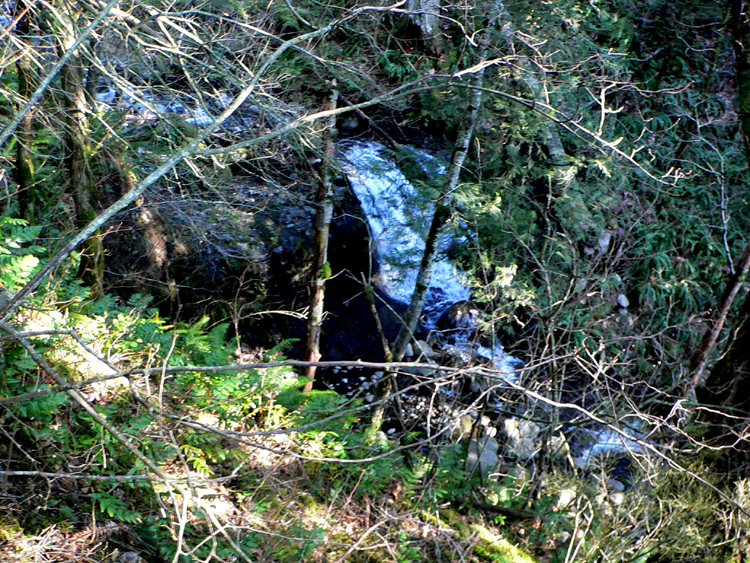
The trail turns left and follows the right side of the creek for a while. The trail starts heading uphill while the creek is heading downhill. Soon you’ll see a small 10-foot waterfall, Upper Cedar Falls to your left – then the creek disappears into nowhere over Cedar Falls. The trail opens up to a viewpoint here, and traverses a bit of a hillside. You’ll get another very unique view of Hamilton Mountain here. Keep your eyes out looking downhill to your left for a view of the falls. When the foliage is thick, and the flow is light it may be a bit hard to spot, but it will be pretty obvious from the small canyon where it is positioned. There is a way to get down to the falls – but it's not here!
Just after this viewpoint, the trail takes a hard turn right at a large burnt snag. Here you make your first decision of the day. This is the junction with the Cedar Mountain trail. Yes, it takes a bit of imagination to see a junction here. The trail up to Cedar Mountain goes straight up the poorly defined ridgeline. The path is a bit hard to track, so a GPS or map/compass combo is mandatory. If you’ve got the energy, this is a great little-known peak and essential fare for Gorge peak-baggers!
For those continuing on, you'll start to see a clearing of sorts on your left at the location of a dried-up lake. Watch for a large out-of-place cottonwood tree down there. This is where you want to get to. Take the trail you're on to the far end of the bowl, then leave the trail and do a short bushwhack down to the clearing. (The trail that continues is the way you will return). Head to the tree and get your bearings.
From the tree, head due south to a gully that would be the outlet stream for the lake that was once here. Here you pick up the trail again. The trail follows the left side of the gully as you start steeply down the hill into the Cedar Creek valley. As you descend you're going to try to find a faint spur trail off to the left that follows the hillside back over to falls. The junction is tough to spot, and the trail is faint. If you can't find it, it's a fairly safe bushwhack back in there. Like most areas in the gorge, there is a lot of blackberry and ferns here. You may want to bring your gaiters and long pants just in case!
After you go see the falls, pick up the main trail again. It goes downhill another 1/8 mile and starts to head to the right. If you pass the turn and end up down at the creek-bed, that's OK. You can follow the creek out to Hamilton Creek. Here you'll head north on the old railroad bed. It will meet right back up with the main trail at the Hamilton Creek Viewpoint. Meanwhile, the main trail crosses a light, seasonal creek, then follows through the woods heading towards Hamilton Creek. For a time, it may seem you will never actually get there as it parallels the creek valley for some distance.
Soon you are at the Hamilton Creek Viewpoint, evidenced by a large slide area. This is a great spot to rest before heading back. Those with the energy can work their way down to the creek bed. This whole area is filled with turn-of-the-century forestry artifacts. Watch for cable-lines wrapped around trees, and side trails where workers were staged. Aficionados know Hamilton Creek to be an especially good place to find old railroad ties and spikes. They've been known to find old barrels and even large equipment as the follow the creek back way up into the highlands.
For our purposes, this is our turn-around point. You can turn back the way you came, but it's a bit of a nicer experience to continue north from the overlook where you'll pick up the old railroad bed. This should be easy to spot. You'll take this about a 1/2 mile until you see evidence of a rockslide. This whole section of trail was altered abruptly back in November of 2006, when a portion of Cedar Mountain gave way. Here you are going to switch off the railbed over the rockslide and pick up a faint trail heading back south parallel to the way you just came up. The trail is going to be a bit hard to spot as you work your way through the rockslide debris, however if you keep heading south at the base of Cedar Mountain you will eventually pick it up. When you get back to the trail, follow it until it connects back to the dried up lake where the cottonwood tree is. Watch uphill to the left to see the Cedar Mountain bluffs.
From this point you can follow the trail back the way you came out to the Dick Thomas Trailhead.
Maps
Regulations or restrictions, etc
- Northwest Forest Pass required
- $2 toll each way at the Bridge of the Gods
Trip Reports
- Search Trip Reports for Aldrich Butte-Cedar Falls Loop Hike
- Table Mountain - Cedar Mountain Figure Eight: 1/21
- Table, Cedar Mountain Loop 06/05/11
- Cedar Mountain / Cedar Falls hike
- Cedar Mountain-twice
- Cedar Mountain - 8 Aug 2009
Related Discussions / Q&A
- Search Trail Q&A for Aldrich Butte-Cedar Falls Loop Hike
Guidebooks that cover this hike
- Day Hikes in the Columbia Gorge by Don J. Scarmuzzi
More Links