Rock of Ages (4/18/2015)

This forum is used to share your experiences out on the trails.
User avatar
mjuliana
Posts: 397
Joined: July 23rd, 2012, 2:32 pm

Rock of Ages (4/18/2015)

Post by mjuliana » April 23rd, 2015, 8:06 pm

I think I get dumber the older I get. Sure...what the heck...Rock of Ages sounds like a great plan. At least last Friday it did. My legs are wondering now about that decision. So maybe dumber is not the cause but just being old and out of shape?

First off, thanks to Bosterson and Lurch for cluing me into the fact that the trail below Triple Falls had been re-opened making the loop possible. So...Saturday morning we set off at 8:30 - we being my son Ben and Spencer, a family friend. We joined the throng of people at the Horsetail Falls TH and started up the first 5 switchbacks but we dropped everyone when we made the turn at the secret tree. Couldn't help but think of Princess Bride and the tree scene with Billy Crystal.

As soon as you turn the corner and Ponytail Falls comes into view ahead, look for the tree on the left. Here's what you are looking for...
Image

Now just start climbing but make sure to take the side trip out to the arch...
Image

View to the east from inside the arch...
Image

and down...
Image

Back to the main trail and then up to the Devil's Backbone. We opted for the wimp way on the forest side after a quick look at the beginning of the ridge. The wimp way just dumps you into the middle so it's easy to backtrack as far as you want (dare).

Image

Ben enjoying the view...
Image

From here up to the junction with Horsetrail Creek Trail was a slog for me. Normally going uphill, I settle into a rhythm but on this day, I just couldn't seem to find it. A few trilliums were blooming along the way though. Have to smile at those...
Image

Crossing the East, Middle and West Fork of Horsetail Creek was easily done either rock-hopping or across logs...
Image

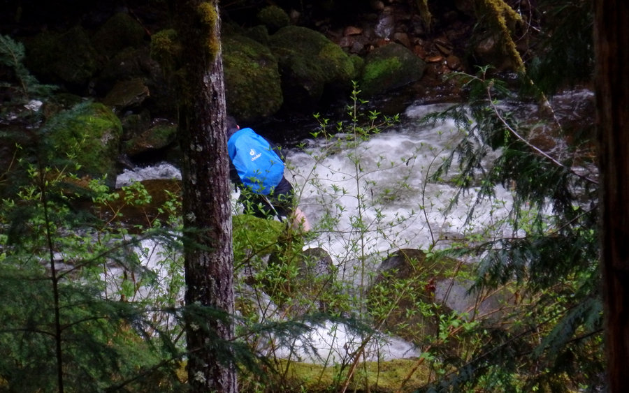
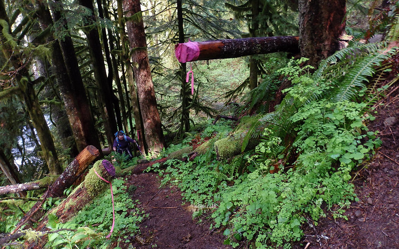
Once you descend the many switch backs to Oneonta Creek, the field guide describes the bridgeless ford...but as other have pointed out this is not necessary. There is a use trail just above the creek on the east side that is flagged by some pink ribbons. Here's the start of it (Ben pulled on the ribbon. It broke. He tied it back on)
Image

Someone has even put down some planks over some muddy sections...
Image

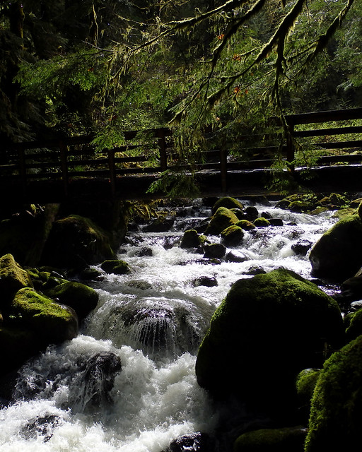
The use trail will take you to a bridged crossing of the creek. When you get here, don't cross the bridge, just stay to the right. It's about here that we started to run into the crowds of people.

Triple Falls is one of the prettiest waterfalls that I've seen...
Image

I do have to say that we watched a coupe of idiots jump over the branch on the left of the photo to the rock island and then back again. Don't understand folks sometimes. They all need to read the book "Ranger Confidential"

Some more waterfalls on the homestretch...
Image

Image

Image

The trails were all in great shape and was just a great day to be outside!
Thanks,
Mike J

User avatar
RobinB
Posts: 803
Joined: September 9th, 2013, 11:29 pm
Location: Portland, OR

Re: Rock of Ages (4/18/2015)

Post by RobinB » April 24th, 2015, 8:46 pm

Nice! Any poison oak up there?

User avatar
greglief
Posts: 640
Joined: May 28th, 2008, 10:03 pm
Location: Northern and Western Hemispheres
Contact:

Re: Rock of Ages (4/18/2015)

Post by greglief » April 26th, 2015, 4:07 pm

Thank you very much for the report and photos! I particularly appreciate your tip on the alternative to the bridgeless ford of Oneonta Creek. :)

Greg

User avatar
mjuliana
Posts: 397
Joined: July 23rd, 2012, 2:32 pm

Re: Rock of Ages (4/18/2015)

Post by mjuliana » April 26th, 2015, 9:08 pm

RobinB wrote:Nice! Any poison oak up there?
Nothing of significance - even better we didn't come home with any :D
greglief wrote:Thank you very much for the report and photos! I particularly appreciate your tip on the alternative to the bridgeless ford of Oneonta Creek. :)

Greg
The ford would not have been fun. From the look of the use trail, it would appear that most folks opt for the alternate route.
Thanks,
Mike J

User avatar
kepPNW
Posts: 6411
Joined: June 21st, 2012, 9:55 am
Location: Salmon Creek

Re: Rock of Ages (4/18/2015)

Post by kepPNW » April 27th, 2015, 10:00 am

mjuliana wrote:
greglief wrote:Thank you very much for the report and photos! I particularly appreciate your tip on the alternative to the bridgeless ford of Oneonta Creek. :)
The ford would not have been fun. From the look of the use trail, it would appear that most folks opt for the alternate route.
My own view is that this website is horribly negligent in not providing information on the ford bypass - indeed, in actually encouraging people to risk their safety, instead! - in the Field Guide here. Three different hikes point to that hazard as the only option, when there's a perfectly dry-boot alternative available. To me, this is far more egregious than all the hand-wringing over Munra recently.

We saw four people fording the creek, perhaps 100 yards above the trail "crossing," needlessly this last Saturday. I wanted to yell out to them, from a few switchbacks above, but it was too late. The remaining choice was to get the heck out of there, so as not to become part of a rescue operation.
  • Image
    Hikers recklessly endangered by the OregonHikers Field Guide? Photo 4/25/15.
The bypass trail is extremely well-established now, and needs to be acknowledged as the safe alternative to that asinine ford.
Karl
Back on the trail, again...

User avatar
retired jerry
Posts: 14425
Joined: May 28th, 2008, 10:03 pm

Re: Rock of Ages (4/18/2015)

Post by retired jerry » April 27th, 2015, 11:41 am

How should the field guide be modified to make this crossing better?

User avatar
miah66
Posts: 2039
Joined: July 6th, 2009, 8:00 pm

Re: Rock of Ages (4/18/2015)

Post by miah66 » April 27th, 2015, 11:42 am

retired jerry wrote:How should the field guide be modified to make this crossing better?
I don't know how everyone feels about detailing "unofficial" routes, but perhaps it is worth mentioning as a possible alternative in the field guide entries for the aforementioned trails, and even perhaps on the Oneonta Ford page as well.
"The top...is not the top" - Mile...Mile & a Half

Instagram @pdxstrider

User avatar
kepPNW
Posts: 6411
Joined: June 21st, 2012, 9:55 am
Location: Salmon Creek

Re: Rock of Ages (4/18/2015)

Post by kepPNW » April 27th, 2015, 11:54 am

miah66 wrote:
retired jerry wrote:How should the field guide be modified to make this crossing better?
I don't know how everyone feels about detailing "unofficial" routes, but perhaps it is worth mentioning as a possible alternative in the field guide entries for the aforementioned trails, and even perhaps on the Oneonta Ford page as well.
I think Tom vetoed noting the bypass trail a couple-few years ago, but it's past time for reconsideration. It's in great shape, and infinitely safer than the potentially lethal alternative. The FG, at the least, needs to clearly state that there's a bridge just 500' downstream of the ford, and well-used trails on each side of the creek.
  • Image
    Looking down the bypass from just above the ford. Pretty damn pink!
Karl
Back on the trail, again...

User avatar
retired jerry
Posts: 14425
Joined: May 28th, 2008, 10:03 pm

Re: Rock of Ages (4/18/2015)

Post by retired jerry » April 27th, 2015, 1:07 pm

I'm not familiar with this. Steve wrote this who isn't around.

So, maybe we should add to http://www.oregonhikers.org/field_guide ... Creek_Ford, after the paragraph for description, add a paragraph:

"There's a bridge about 500 feet down the creek if the crossing seems at all dangerous."

or what?...

User avatar
kepPNW
Posts: 6411
Joined: June 21st, 2012, 9:55 am
Location: Salmon Creek

Re: Rock of Ages (4/18/2015)

Post by kepPNW » April 27th, 2015, 1:13 pm

retired jerry wrote:I'm not familiar with this. Steve wrote this who isn't around.
My sense is the bypass trail has grown organically since that FG entry was written.
retired jerry wrote:So, maybe we should add to http://www.oregonhikers.org/field_guide ... Creek_Ford, after the paragraph for description, add a paragraph:

"There's a bridge about 500 feet down the creek if the crossing seems at all dangerous."

or what?...
And a damn fine bridge it is, too!
  • Image
I'd suggest also adding that there are trails following the creek on both sides, between Horsetail Creek trail and the bridge.
Karl
Back on the trail, again...

Post Reply