Portland Hikers ArchiveReturn to Portland Hikers Archive Drift Creek Falls and Suspension Bridge, 1-4-07 Posted by OneSpeed (2007-01-11)
| Drift Creek Falls
January 4, 2007
A research trip for the third edition of my book, due in April 2007.
LAT: 44°55.900�
LONG: 123°51.087�
Total Miles: 3.6
Elevation Gain: 391�
Level of Difficulty: Easy
Family Friendly: Yes
Season: Year-round, but with some snow in winter.
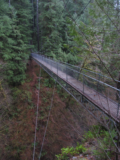
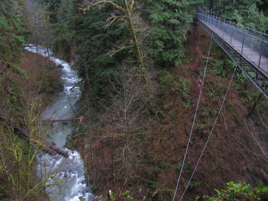
Here�s a hike that packs mystery and goofiness. It�s in the middle of nowhere. It�s short. It�s frankly boring. It leads nowhere except to a nice waterfall. And it has an incredible � I mean spectacular bridge! 240 feet long, a hundred feet high, over a gorge with two creeks and the falls � and then, at the far end of he bridge, the trail just kind of � dies.
I mean, it�s a nice waterfall, and a decent trail that seems to be in good shape year-round. But it�s like a two-hour drive, and less than four miles of walking � to a bridge! I�ve been twice now, both times for book research, and I think I�m finally getting it. It�s not about the hike, or even the falls, really. It�s about the bridge. Where else (around here) can you experience such a thing?
Here�s what I wrote in my second edition of my book about it (and yes, I love it when I quote myself!):
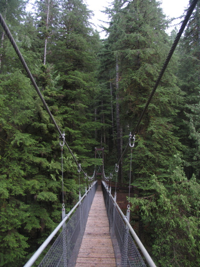
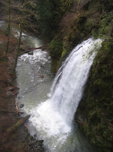
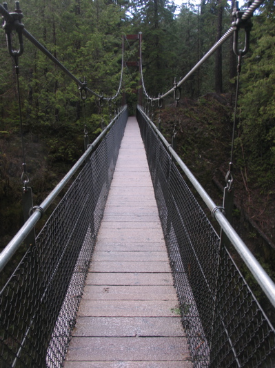
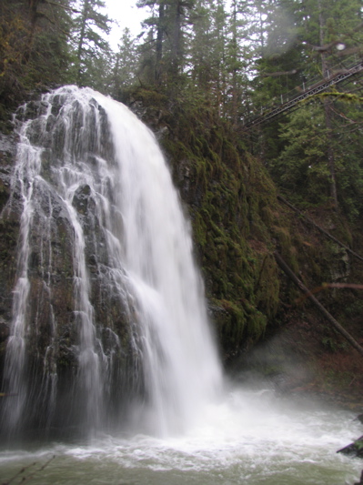
Built in 1997, the Drift Creek Falls Suspension Bridge is 240 feet long, 3 feet wide, and 100 feet above the canyon floor. The falls to your right are 80 feet high�and you�re above them! A few more technical details: the towers are 29 feet tall and made of Douglas fir beams 12 by 18 inches thick. The anchors include 28 cubic yards of concrete and 10-foot rock bolts. The mainlines are 1-1/4 inch galvanized wire rope. Also of note is that the same company that built this bridge also built the one over Lava Canyon.
And how do they build such a thing, you might wonder (I did). They flew in materials with a helicopter, and built the main span from a �skyline� more than 100 feet off the ground�not a business for anybody afraid of heights.
So, first the drive. You go out towards Lincoln City and take a left where a sign says Drift Creek Bridge � but that�s not the bridge you�re after. (I said this hike is goofy, didn�t I?) There�s a �Drift Creek Covered Bridge� that you�ll drive by, but it doesn�t go over Drift Creek, and it was built in 2001. But nothing is as weird as the story behind this so-called historic covered bridge. Stop to check it out, and make sure you get the single-page flier that tells the dramatic, traumatic story of how this bridge came to be, again. It�s got divine interventions, near divorces, plenty of tears � I�m serious. And they put this out for people to read! The bridge, by the way, goes to somebody�s yard.
Okay, alright, the hike. It hailed and rained when I was driving there, leaving a nice layer of slurpee over the road:
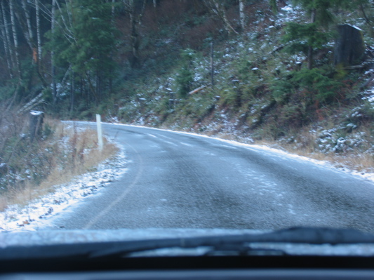
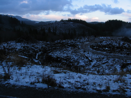
Fortunately, this stuff never froze, or I would have become the latest rescue story. I got to the trailhead, which is about 10 miles down a mostly-paved road, past all sorts of lovely Coast Range scenery:
So I start down the trail, and the weather is nice, and that�s good, and then 200 yards down the trail, there�s a trash can. Why this isn�t at the trailhead, I have no idea. The hike is like being in Forest Park � a young forest, plenty of stumps, no views. But even in the middle of winter, it was in fine shape, no mud at all.
About half a mile in you come across a �North Loop� trail, which I took because I�d never heard of it. Of course, the sign said nothing about where it went, so it was an act of faith. Where it led was around a loop back to the trail, and it may have been worth it because it visited some actual, mature forest � for about a minute. Then it reached the shore of ... some creek (not labeled anywhere) ... and rejoined the main trail, which soon crosses the creek:
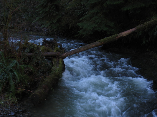
(Sorry for the lack of light here � that�s January in the Coast Range for ya!)
A total of 1.7 miles out, you reach the real bridge and the falls � which, of course, are not on Drift Creek. The bridge goes over Drift Creek, but the falls are on something else that flows into it. At least, on my map, the falls creek isn�t labeled, but it might be the North Fork of Drift Creek � not that any signs identify anything around here, or much on the map, like this trail. Strange hike! But who cares? Here�s the scene, which really is impressive (these are taken in the order in which you�d see it there).
The bridge as you first see it:
Looking across it:
The falls from up on the bridge:
Looking back across the bridge:
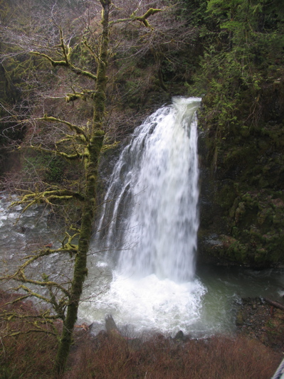
The trail goes on down beyond the bridge maybe 0.1 mile to the side of Drift Creek, from where the falls make an even more impressive site. There�s also a heck of a blowdown by the creek, which is fun to crawl through. And, of course, this is where it started to hail again:
(See the bridge in the upper right?)
So I slogged on out to my car, where even in the miserable weather, on a long day and a strange hike, I was flying the team colors:
All in all, an interesting day, and worth it to get out there. I�d recommend it, I suppose, but mainly if you combine it with breakfast at the Otis Café and/or a run to the casino in Lincoln City � or maybe a hike at Cascade Head. And seriously, you must stop at the covered bridge and read its history. Amazing what people will share with the public! | Re: Drift Creek Falls and Suspension Bridge, 1-4-07 Posted by pdxgene (2007-01-11)
| | If you go on a really windy day, the suspension bridge is much more fun... : ) | Re: Drift Creek Falls and Suspension Bridge, 1-4-07 Posted by Sweetcat (2007-01-11)
| Ah, thank you for bringing back memories of my very first "official hike" in 2001. That's when it all started for me. I agree it's a rather boring hike, but the bridge is worth it. I'd heard a while back they were going to make a loop trail out of it, but that doesn't seem to have happened yet. You can also get to the access road to the trailhead from Hwy 101, just South of Lincoln City (11 miles). Oh yes, the trail "loses" elevation to the falls, so it's a little bit of a workout climbing back out of it. Is it still a Northwest Forest Pass site?
Ellen |
Return to Portland Hikers Archive
Disclaimer:
Information found on PortlandHikers.org and PortlandHikersFieldGuide.org is
provided by website visitors and volunteers and should be considered anecdotal. All trails
and directions and subject to current conditions. Trails and roads can be rerouted due to
natural events and the website is not able to provide current information for every hike.
Please verify against two other sources before planning a trip. Outdoor activities present
inherent risks. Portlandhikers.org, nor any of its members, accept liability for injuries
relating to information found on this website.
|
Powered by phpBB © 2008 phpBB Group
|
|
© 2008 PortlandHikers.org - No content shall be copied or downloaded without permission
|
|
 |
