Jefferson backpack route

Jefferson backpack route
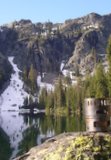
Looks like me and some friends are finally going to get to see the most beautiful part of Oregon that we haven't seen before this coming weekend, and I'm looking for ideas. We're taking three days, Saturday to Monday, so maybe the days in and out are a bit shorter mileage to allow for the drive. The two nights backpack camping may or may not be at the same place. I was told that the reserved locations are full for Saturday night but not Sunday. Jefferson Park looks like a fairly small area so the trip need not be confined to the park though I assume that would be the focus. Any suggestions for an overall route, or at least alternative campsites outside of the reserved areas would be welcome.
-
mattisnotfrench

- Posts: 1318
- Joined: May 28th, 2008, 10:03 pm
- Location: SE Portland
- Contact:
Re: Jefferson backpack route
If you don't mind hunting around for a campsite you can head up the South Breitenbush Trail or the PCT from Jefferson Park up and out of Jefferson Park. The views are great and there are springs all over for water. I'm not going to reveal specific campsites here but if you message me I can give you some more specific ideas about Jefferson Park.
Another option is to get a permit for the Pamelia area, and hike in there on Saturday to the lake. Then do the Hunts Cove loop on Sunday, with maybe a side trip to the Table viewpoint or even Table Lake if you have the time. Return to Pamelia Lake. On Monday, hike up Grizzly Peak before returning to the trailhead.
There are lots of other ideas in my book.
Author of Extraordinary Oregon!, PDX Hiking 365, 101 Hikes in the Majestic Mount Jefferson Region, and Off the Beaten Trail. Website: www.offthebeatentrailpdx.com
-
cunningkeith
- Posts: 209
- Joined: June 26th, 2010, 4:28 am
- Location: Portland
Re: Jefferson backpack route
I can't believe you haven't been to Jeff Park! That was the first place I went when I moved to Oregon. Bad experience: late June, mosquitoes drove us bonkers. Ah, backpacking . . . learn by doing.
So here are my suggestions:
Option 1: Leave from Pamelia Lake trail and spend night 1 in Hunts Cove. Next day cross up from Hunts Lake to Shale Lake (x-country but easy). Head on PCT north to Jeff Park, camp there night 2. This is in the low 20 mile range for the whole trip. The problem will be getting the permit for the first night in Hunts Cove, which is part of the Pamelia Lake area.
Option 2: Park at PCT north of Jeff Park near Breitenbush Lake. Hike south and camp first night 0.5 to 1 mile north of Park Ridge (outside limited Jeff Park area). There are a few camps along the PCT north of Park Ridge, and you can make a fire, which is nice this time of year. The whole area has a subalpine feel, and this is considered the classic approach to Jeff Park. Next day camp in Jeff Park. This will be a very short hike, but then you can explore around Jeff Park for the day. Return the way you came. This trip is about 13 miles.
Option 3: (similar to Option 1, but assuming the limited entry to Pamelia Lake is taken and you can't get a permit in Pamelia for night 1): Take Woodpecker trail . Meet PCT, head south to Shale Lake and camp outside the limited entry area somewhere around Goat Peak. There look like there are some tarns there on a map. Next day head north on PCT and camp in Jeff Park. (I've never done this trip but have been in most of the areas and not sure if you can even enter the Pamelia Limited Entry on PCT w/out permit. But I'm assuming you can b/c how else do thru hikers do it? The problem with this plan is it makes for a long first day. This trip is in the low 20 mile range.
Re: Jefferson backpack route
I haven't been there because I live in the Gorge and it is a very inconvenient drive to get there. Add in crowds and a reputation for mosquitoes and it always seemed like one of those places to put off till well into September, leaving a narrow window.
Anyway, any updates on road conditions? Are the descriptions in the Field Guide still accurate?
Anyway, any updates on road conditions? Are the descriptions in the Field Guide still accurate?

Re: Jefferson backpack route
drm,
Most ppl go in via Whitewater trail. The road is fine. I have also gone via S. Breitenbush, also an easy drive, which is slightly longer hike with opportunity to explore Triangulation trail, Triangulation peak, Boca Cave and Grizzly Peak. Crag trail is a fun "lost" trail exploration, though it does require a bit of rhody schwacking.
Most ppl go in via Whitewater trail. The road is fine. I have also gone via S. Breitenbush, also an easy drive, which is slightly longer hike with opportunity to explore Triangulation trail, Triangulation peak, Boca Cave and Grizzly Peak. Crag trail is a fun "lost" trail exploration, though it does require a bit of rhody schwacking.
"The top...is not the top" - Mile...Mile & a Half
Instagram @pdxstrider
Instagram @pdxstrider
-
mattisnotfrench
- Posts: 1318
- Joined: May 28th, 2008, 10:03 pm
- Location: SE Portland
- Contact:
Re: Jefferson backpack route
When I hiked the Crag Trail last fall it wasn't difficult to follow for 99% of the way to the Triangulation Trail. The only difficult spots are right after you cross the South Breitenbush and a few spots in the last half-mile before the Triangulation Trail. People are maintaining the trail as they go - it was judiciously flagged, and it was clear that people were trimming the brush when they could. The tread is in great shape for a lot of the trail:miah66 wrote:drm,
Most ppl go in via Whitewater trail. The road is fine. I have also gone via S. Breitenbush, also an easy drive, which is slightly longer hike with opportunity to explore Triangulation trail, Triangulation peak, Boca Cave and Grizzly Peak. Crag trail is a fun "lost" trail exploration, though it does require a bit of rhody schwacking.

Honestly, it's in better shape than a decent number of officially maintained trails I've seen elsewhere. But I'm not sure I'd want to carry a full pack up it - it's steep and still quite brushy in spots.
Here's a track if anybody wants one:
http://gpsfly.org/g/5550
Author of Extraordinary Oregon!, PDX Hiking 365, 101 Hikes in the Majestic Mount Jefferson Region, and Off the Beaten Trail. Website: www.offthebeatentrailpdx.com