McNeil Pt 11/21/15

This forum is used to share your experiences out on the trails.
wnshall
Posts: 188
Joined: July 17th, 2009, 10:31 am

McNeil Pt 11/21/15

Post by wnshall » November 22nd, 2015, 12:43 pm

I took advantage yesterday of the forecast for sunny skies to get in one last hike up high on Mt Hood. On the morning drive towards the mountain, Hood gleamed white against the deep blue ski, and I anticipated a sunny, if cold, day. Something like this:
Image

Imagine my surprise, during the last 2 miles approaching the trailhead, to find a layer of fog blowing through the trees, coating everything in icy white.

Image

Image

At the trailhead it was 25 F at 10:30 am. There was about half an inch of snow, mixed with ice and frost. And a brutally cold wind.

Image

Image

Image

Image

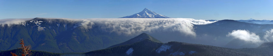
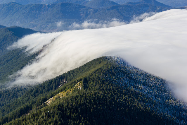
When I reached the first opening on the side of bald mountain, I could see the fog pouring down the side of the ridge. A cold north wind was whipping fog up over the ridge and down the south side. I took some video, but couldn't figure out how to link it here.

Image

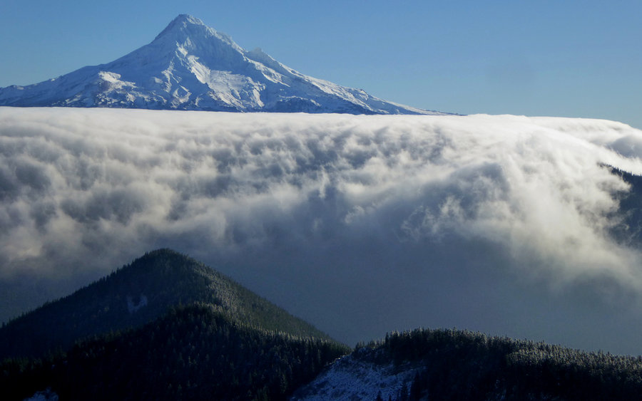
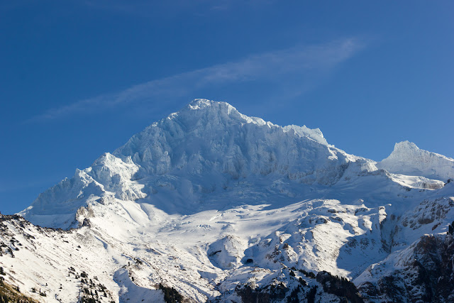
The normally spectacular view of Mt. Hood was obscured by the fog, only showing intermittently.

Image

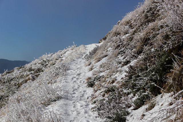
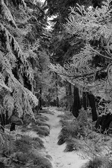
A rare clear view of the trail.

Image

The fog coated trees and shrubs in fantastic suits of white.

Image

Image

Image

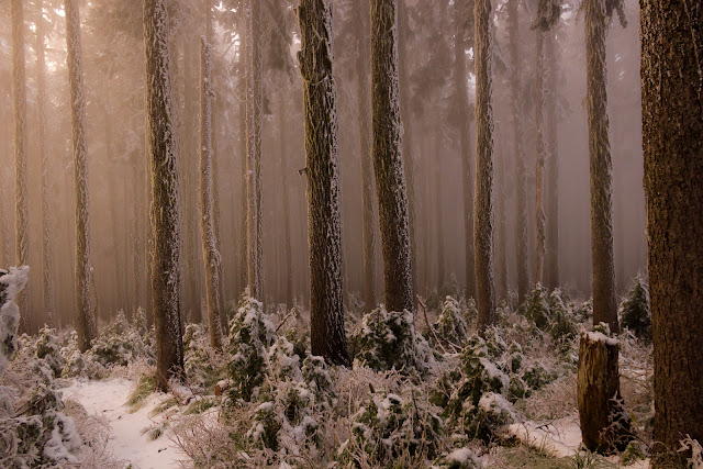
The tree branches in the woods were only coated on the windward side:

Image

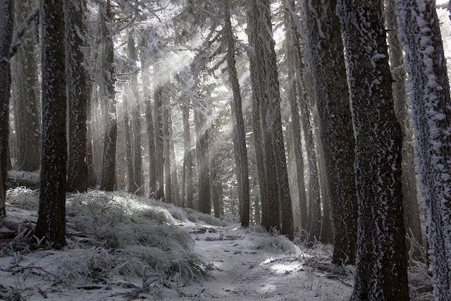
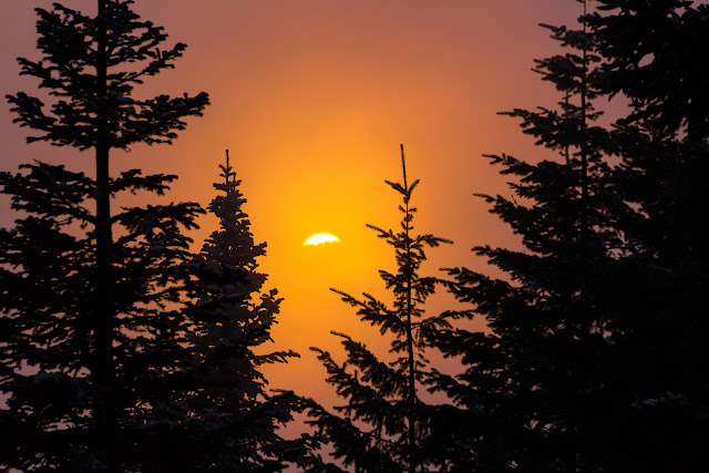
sun beams in the forest, a ray of hope.

Image

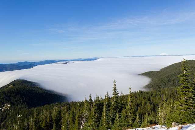
Just after this picture, in the span of about 20 paces, the temperature raised 15 degrees and the wind stopped. I stepped out into the second viewpoint to calm, blue skies. It was so warm I had to start peeling off layers. My thermometer said it was 60 degrees!

Image

Image

View up to McNeil pt and beyond:

Image

The caves on Sandy glacier are easy to see:

Image

From here, the trip was a lot more pleasant due to the significantly warmer temperatures. I took the steep scramble up to the shelter. In the clearings at the base of the scramble there was maybe 8 inches of snow, but it was pretty hard packed and easy to walk through. Up on the scramble it looked like this:

Image

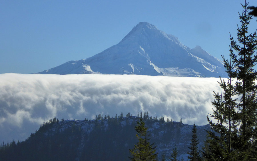
Near the top of the scramble, the height allowed me to see where I'd been. A huge bank of fog extended towards the gorge, held back by the Bald mountain ridge. You can see where it was pouring over the ridge and down the other side. The trail on the side of Bald mountain passes right through that.

Image

Image

Image

Image

Image

Image

McNeil shelter, picturesque as always:

Image

Image

Image

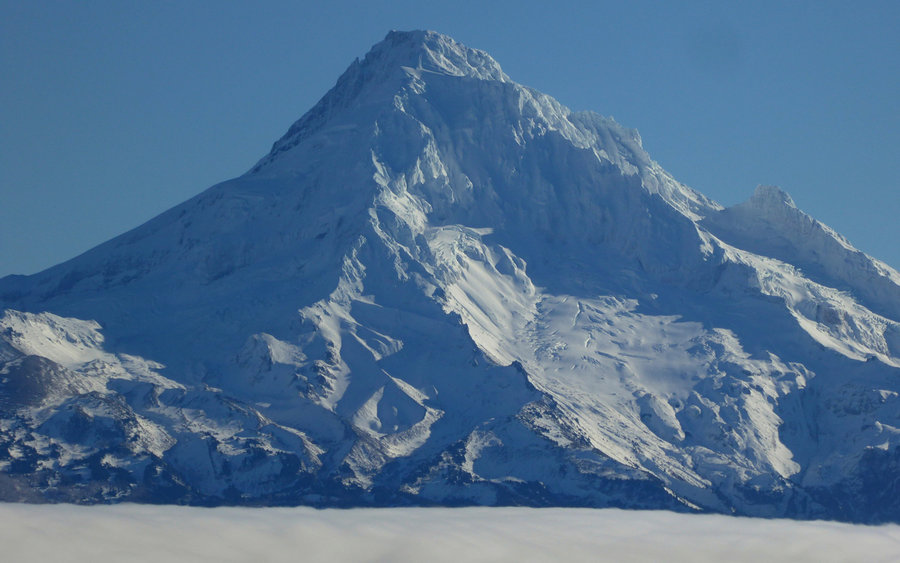
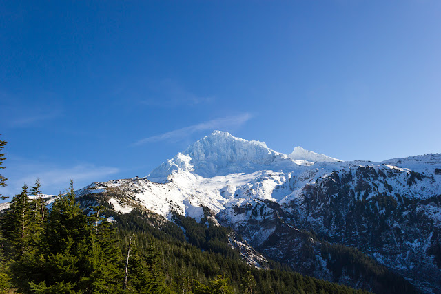
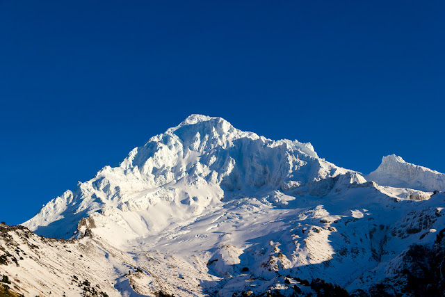
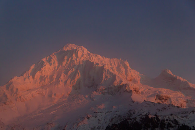
Photo looking up to Hood from the shelter:

Image

Closeup of the caves:

Image

I hiked up the ridge above the shelter a little bit. I thought I would try going up a little way, and then down the other side of the ridge back towards the regular McNeil Pt trail. As I hiked up the ridge, I could see some tracks across the snowfield I needed to get to. I figured these followed the regular trail, or at least would take me to it. I couldn't get to them directly, because the slope was too steep and was in the shade, so was still iced up. I decided to go up to the local peak, and down the other side of the bowl. It was a little dicey because the snow up there was pretty hard and icy, but by staying on rocky areas I was able to keep my footing.

The view of Barrett Spur from the high point of my trek:

Image

And the other direction:

Image

As I worked my way down the other side of the bowl and approached the tracks I realized they were deer tracks and not the trail at all! From here, I just continued down towards where I thought the trail was. Apparently no one had been up on the trail in the last couple of days, because I couldn't find any tracks. The snow here was about a foot deep and a little harder going, but not too bad. I made it back to the Timberline trail, which was much easier to follow.

The ponds:

Image

It was starting to get late, so I boogied down the trail. I took one last set of pictures of Hood, before descending into the fog. If you look carefully you can see the shelter in this picture.

Image

Image

Image

I kind of dreaded re-entering the icy fog. Once again, the temps plummeted and the wind picked up in just a short distance down the trail.

Image

Image

By now the sun was setting, and the pink sun shinning through the fog gave the forest an eerie glow:

Image

Image

Image

Image

At the last viewpoint on Bald Mt. I had my last glimpses of Hood through the fog bathed in pink.

Image

Image

Image

Image

What a great day on Mt. Hood!
Last edited by wnshall on November 23rd, 2015, 9:02 am, edited 1 time in total.

User avatar
jdemott
Posts: 651
Joined: July 23rd, 2010, 1:43 pm
Contact:

Re: McNeil Pt 11/21/15

Post by jdemott » November 22nd, 2015, 1:22 pm

Great report! That fog may have been cold, but it sure gave you some wonderful photos! The shots from your way back home are especially great. Thanks for posting.

User avatar
aiwetir
Posts: 603
Joined: December 10th, 2014, 11:54 am
Contact:

Re: McNeil Pt 11/21/15

Post by aiwetir » November 22nd, 2015, 3:05 pm

Spectacular photos.
- Michael


User avatar
Sean Thomas
Posts: 1647
Joined: February 25th, 2012, 11:33 pm

Re: McNeil Pt 11/21/15

Post by Sean Thomas » November 22nd, 2015, 7:23 pm

Amazing photos!

User avatar
adamschneider
Posts: 3717
Joined: May 28th, 2008, 10:02 pm
Location: SE Portland
Contact:

Re: McNeil Pt 11/21/15

Post by adamschneider » November 22nd, 2015, 10:38 pm

Wow. :shock:

User avatar
Chip Down
Posts: 3043
Joined: November 8th, 2014, 8:41 pm

Re: McNeil Pt 11/21/15

Post by Chip Down » November 22nd, 2015, 10:44 pm

Aha!
One day behind you, I was headed up that way today to see if I could catch PCT towards Muddy Fork. Decided against it, worried about roads. Looks like I should have tried it. Damn.
But yeah, from Paradise Park today I noticed the low clouds in that area were coming from the north, and the north-facing slopes were white (whereas everything else I could see was old snow, no white in the trees). Almost snapped a pic. Wish I had, so I could share here.

Anyway, great pics.

My first trip to McNeil was about this time of year, up the Mazama Trail. Thin layer of clouds above trailhead, sunny above, but cold and damn windy, so yeah, I feel your pain.

BTW, I've been noticing some weird abrupt temperature changes too in the last week or so. Numb fingers and toes, and then wearing nothing but tee shirt, in a matter of minutes.

Finally, it's "Barrett Spur" ;)

User avatar
kepPNW
Posts: 6411
Joined: June 21st, 2012, 9:55 am
Location: Salmon Creek

Re: McNeil Pt 11/21/15

Post by kepPNW » November 23rd, 2015, 6:05 am

Stunning photography!!! :shock: :D

We were sixteen miles away, watching the vaporfalls from the other side. What an incredible damn day!!! :mrgreen:
  • Image


    Image


    Image


    Image
Karl
Back on the trail, again...

wnshall
Posts: 188
Joined: July 17th, 2009, 10:31 am

Re: McNeil Pt 11/21/15

Post by wnshall » November 23rd, 2015, 9:05 am

Chip Down wrote:Aha!
One day behind you, I was headed up that way today to see if I could catch PCT towards Muddy Fork. Decided against it, worried about roads. Looks like I should have tried it. Damn.
Yeah, it became hazy in the valley during the day yesterday, but I suspect Hood was above all that.
Finally, it's "Barrett Spur" ;)
[/quote]
Ugg, a brain freeze! I mix those two up when I say them, but typing them?

wnshall
Posts: 188
Joined: July 17th, 2009, 10:31 am

Re: McNeil Pt 11/21/15

Post by wnshall » November 23rd, 2015, 9:08 am

kepPNW wrote:Stunning photography!!! :shock: :D

We were sixteen miles away, watching the vaporfalls from the other side. What an incredible damn day!!! :mrgreen:
Were you in the Gorge? I assumed this cold fog bank filled the Gorge, but your pictures and the Tanner Butte trip report from the same day suggest that it was clear. I'm going to have to look more closely at the geography and figure out where that pool of cold air was sitting. Is it sandwiched between Mt. Hood and the ridges along the Gorge?

Post Reply