Donaca Lake Adventure Loop 9-9-13

This forum is used to share your experiences out on the trails.
Post Reply
User avatar
jessbee
Posts: 877
Joined: May 28th, 2008, 10:03 pm
Contact:

Donaca Lake Adventure Loop 9-9-13

Post by jessbee » October 21st, 2013, 10:01 pm

Well it took me a while to write this one up, but finally here it is. A tale of misadventures at Donaca Lake...

Chimney Peak Trail > Donaca Lake > Rd 2041 and mystery trail back
14 + miles | 1700' ele. gain | many hours


Image

See all the photos on Google Plus.

It all began with a childhood memory. Aaron had hiked to Donaca Lake as a high school kid, doing trail work with the Forest Service. He hadn't remembered which trails they took, but he clearly remembered the lake itself. Flipping through an old copy of Sullivan's Central Cascades book, I found an interesting loop to Donaca Lake that finished up along a forest road that had been destroyed by a landslide. That was enough to pique my interest.

Image

Image

Image

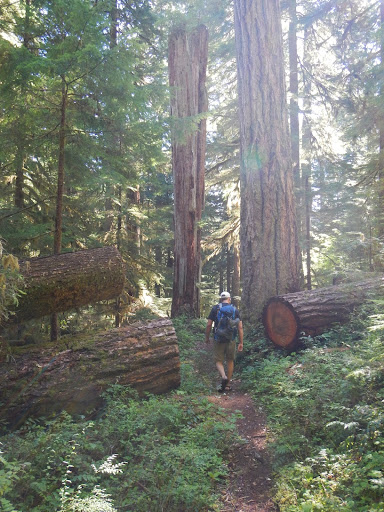
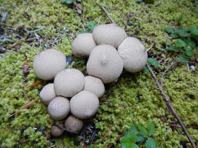
We started walking amid lush greenery in an old-growth forest that made us feel really tiny. We quickly reached the first water crossing, which we managed to do by hopping across the rocks. Two more miles of walking brought us to another crossing, in which my Crocs came in handy. Then another three and a half miles passed by before we reached Donaca Lake. Tucked away in the lonely Middle Santiam Wilderness, Donaca Lake remains pristine and scarcely visited. At least, it sure looked that way, with its one campsite and no human litter left behind. To us, it made a superb lunch and resting spot.

Aaron took a chilly dip in the water while I enjoyed the late summer sunshine falling down onto the small beach. It was a lazy afternoon.

Image

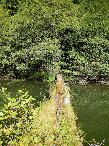
Wanting to explore a bit, we took a walk out on a large log that had long ago fallen into the lake. This was the coolest nurse log I'd ever seen. We walked out as far as we dared before the ground beneath our feet felt unstable and downright swampy. Yes, the rotten log turned into mush. It oozed into the holes in my Crocs, bathing my feet in tree soup. The vegetation growing out of the log cascaded over the side and into the water, providing excellent habitat for newts. They were swimming throughout the lake, but were particularly abundant here. The lake was so clear, we could easily see the critters hanging out on the sandy bottom. That is, until we stepped off the log.

The texture of the lake's bottom was like quicksand. I put one foot on a branch and the other into the sand; it just kept sinking. I could feel other sticks and debris in the earth that rubbed against my leg, but there was nothing substantial to stand on. It was such a surreal feeling, to be standing in a bottomless slurry of ash and water, out in the middle of nowhere.

Image

I could have stayed here all day but we'd already lingered for a couple hours and we still had a long way to go.

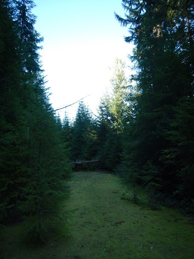
We decided to take the adventurous route back that the Sullivan book mentioned as "another option." We followed Chimney Peak trail back to where it crossed road 2041. The road had been reclaimed by the forest for a few decades, giving it an eerie, post-apocalyptic vibe. Moss covered the old gravel surface. Blackberry runners streamed across the mossy coat, forming a loose mat of green vines. Trees encroached the road's edge, subtly in some places and boldly in others. As we continued along the old road we enjoyed the soft carpet of greenery that made walking especially easy and pleasant.

Image

Image

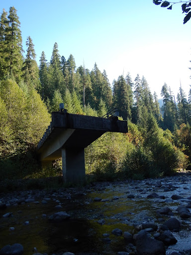
At the Pyramid Creek Crossing, we walked to the road's edge. The concrete bridge had been removed, leaving what looked like a giant diving board at the other side of the river. We dropped down to the water's edge, changed into river shoes, and waded across. From here, things got interesting.

Image

We followed the road easily for a little while longer. The bridge over the Middle Santiam was still in.  But after that, the road narrowed and became more difficult to follow. At some point, we picked up a new trail that led through the worst of the washed out sections. Although it wasn't on our map, we figured it must lead the way out of this mess. We followed the trail until we popped out, surprisingly, on a well-manicured trailhead parking area. There was a forest service signboard with a wilderness permit box (well-stocked with fill-in-the-bubble permits) and a few miscellaneous signs. There was no name on the signboard or map to indicate where we were. Strange.

We followed the gravel road leading out of the parking area and ended up on another, nicer looking, gravel road. There was no sign to indicate our location. Daylight was fading, we had no idea where the car was, and we were lost on a road. We had two choices, left or right. By our estimates and the compass direction, we guessed right.

And so we took off to the right, barreling down the road, looking for any clue to our present location. There was a milepost marker, some large brush piles along the road, and nothing else. There were also a few spur roads leading off of the main drag. We walked for over a mile with no success. Well, maybe just a little further, around the next bend, we said over and over again. Ultimately we decided we chose the wrong direction and turned around.

Walking, walking. The temperatures were dropping fast. We were getting tired of road walking and all I wanted was to eat dinner. We passed by the spur to the newly discovered trailhead and kept going. We had to be on the home stretch. Finally, we reached a junction and sign that we recognized, the 4- way intersection with Road 646. Half a mile later, we collapsed at the car. We made it before dark.

Since returning home, I've searched the Internet and all my books and maps for some information relating to the new trail. I've come up with nothing. The forest service website doesn't mention it, no maps show this trail and no one's written up a trip report about it. Sullivan's latest book took this loop description out and relegated the hand-drawn map to the back of the book. I wonder when this trail was put in, who's maintaining it, and what the name of the new trailhead is. Obviously people know about it, since the permit box was stuffed with completed permits. Please leave your comments with anything you know about the recent history of the trail. And perhaps, save someone else the trouble of wandering around as we did.
Will break trail for beer.

Blog and photos

User avatar
mattisnotfrench
Posts: 1318
Joined: May 28th, 2008, 10:03 pm
Location: SE Portland
Contact:

Re: Donaca Lake Adventure Loop 9-9-13

Post by mattisnotfrench » October 22nd, 2013, 9:43 am

This is a fantastic report, albeit a bit terrifying. You've certainly given me reason to not bother with the road walk back from Donaca Lake whenever I go there. I'd never heard anything about there being separate trails / trailheads so that's really weird. Did you try asking the Sweet Home Ranger Station?

This seems like a beautiful place and it's somewhere I'd love to visit soon. It also really seems like a "Jessbee" kind of place.

Great report!
Author of Extraordinary Oregon!, PDX Hiking 365, 101 Hikes in the Majestic Mount Jefferson Region, and Off the Beaten Trail. Website: www.offthebeatentrailpdx.com

User avatar
jessbee
Posts: 877
Joined: May 28th, 2008, 10:03 pm
Contact:

Re: Donaca Lake Adventure Loop 9-9-13

Post by jessbee » October 22nd, 2013, 3:19 pm

Ha! I wouldn't call it terrifying. We just felt really stupid for being lost on a road. Actually, walking down the old road was really cool, seeing the forest resorbing any sign of human interference.

And it's so strange that there's nothing on the Internet about the new trailhead. I know I need to call the Sweet Home Ranger Station to get answers, but the forest service is never in the office when I get the notion to call or drop by. Guess I'll just have to plan a mid-week getaway soon. :D
Will break trail for beer.

Blog and photos

User avatar
GoneHiking
Posts: 19
Joined: October 28th, 2011, 7:59 am

Re: Donaca Lake Adventure Loop 9-9-13

Post by GoneHiking » October 23rd, 2013, 8:36 am

The 2012 Detroit Ranger District map does show a trailhead located on the SE corner of the Middle Santiam Wilderness with an unnumbered trail connecting to the Chimney Peak Trail #3382.

I checked the information for trail 3382 on the WNF web site and it does mention this trailhead...

From Sweet Home, travel east on Highway 20 for 23.3 miles; turn left on Forest Road 2041 (Soda Fork). Stay on 2041 for 12 miles to spur road 646 and turn right. The trailhead is at the end of the spur road.

You may also reach a mid-point in the trail by continuing down 2041 for an additional 3 miles to the road closure. Travel by foot 2 miles further along 2041 to the original trailhead. This route shortens the total hike by approximately 3 miles and bypasses the need to wade the Middle Santiam River and Pyramid Creek.


Could this be the trailhead you found?

User avatar
jessbee
Posts: 877
Joined: May 28th, 2008, 10:03 pm
Contact:

Re: Donaca Lake Adventure Loop 9-9-13

Post by jessbee » October 23rd, 2013, 9:03 am

GoneHiking wrote:The 2012 Detroit Ranger District map does show a trailhead located on the SE corner of the Middle Santiam Wilderness with an unnumbered trail connecting to the Chimney Peak Trail #3382.

I checked the information for trail 3382 on the WNF web site and it does mention this trailhead...

From Sweet Home, travel east on Highway 20 for 23.3 miles; turn left on Forest Road 2041 (Soda Fork). Stay on 2041 for 12 miles to spur road 646 and turn right. The trailhead is at the end of the spur road.

You may also reach a mid-point in the trail by continuing down 2041 for an additional 3 miles to the road closure. Travel by foot 2 miles further along 2041 to the original trailhead. This route shortens the total hike by approximately 3 miles and bypasses the need to wade the Middle Santiam River and Pyramid Creek.


Could this be the trailhead you found?
Hmm...thanks for the info. I don't have a Detroit Ranger District Map, so I'll put that on my wish list. I'd be curious to see the layout of that trail.

As for the alternate directions to the old trailhead, I don't think that was it. We had to come up a spur road from the trailhead we found, and it was less than 3 miles away from the car. But now I wonder where THAT would be, relative to our journey. Plus, we still needed to wade on the return trip along 2041--where the bridge is out.

OK I'm designating Friday as a hike day, looks like I'll take a drive out to the ranger station to ask some questions...
Will break trail for beer.

Blog and photos

User avatar
GoneHiking
Posts: 19
Joined: October 28th, 2011, 7:59 am

Re: Donaca Lake Adventure Loop 9-9-13

Post by GoneHiking » October 23rd, 2013, 9:58 am

Here's a scan of the Detroit Ranger District map showing the two trailheads for Donaca Lake/Chimney Peak trail #3382
Attachments
DonancaTrailheads.jpg
Southwest corner of Middle Santiam Wilderness with trail #3382 to Donaca Lake

User avatar
VanMarmot
Posts: 1924
Joined: May 28th, 2008, 10:03 pm
Contact:

Re: Donaca Lake Adventure Loop 9-9-13

Post by VanMarmot » October 26th, 2013, 5:49 am

Nice TR! That picture of the "bridge to nowhere" was interesting. Got to wondering why they didn't leave it intact and put a trail on it? Probably some concern that it would someday collapse under a hiker and lawyers would be called. Still, seems like a waste of already invested resources.

After a lost trail debacle in the Elk Horns, the loved one and I learned just how useful those district maps can be when there are a lot of old roads around or when things have changed in just the last few years. A good resource for hike planning.

User avatar
Splintercat
Posts: 8334
Joined: May 28th, 2008, 10:03 pm
Location: Portland
Contact:

Re: Donaca Lake Adventure Loop 9-9-13

Post by Splintercat » October 26th, 2013, 9:58 am

Ha! I wouldn't call it terrifying. We just felt really stupid for being lost on a road.
That's the only time I've ever been truly lost, Jess -- on a tangle of logging roads! Ended up spending the night and unraveling our path at dawn... fortunately, nobody was expecting us, so no harm done... except to our tender egos! :lol:

Glad you made it out okay! This is the first mention I've heard of Donaca Lake since the wilderness battles of the early 80s, so a nice blast from the past.

Tom :)

flynnes
Posts: 1
Joined: July 2nd, 2015, 3:30 pm

Re: Donaca Lake Adventure Loop 9-9-13

Post by flynnes » July 2nd, 2015, 3:46 pm

Thanks for the post about the hike to Donaca Lake. We are 4 women over the age of 60 who are planning a back pack trip to the lake this month. Your photos and description were very helpful as we like to know where we are going and how to get there before we start out!

Post Reply