Caltopo is adding support for a product called Mapbuilder. Mapbuilder allows you to build a custom map using layers, such as trails, roads, contours, hydrology, etc.
It currently being implemented. You can read about it here http://caltopo.blogspot.com/
It's been said "A pictures worth a thousand words"
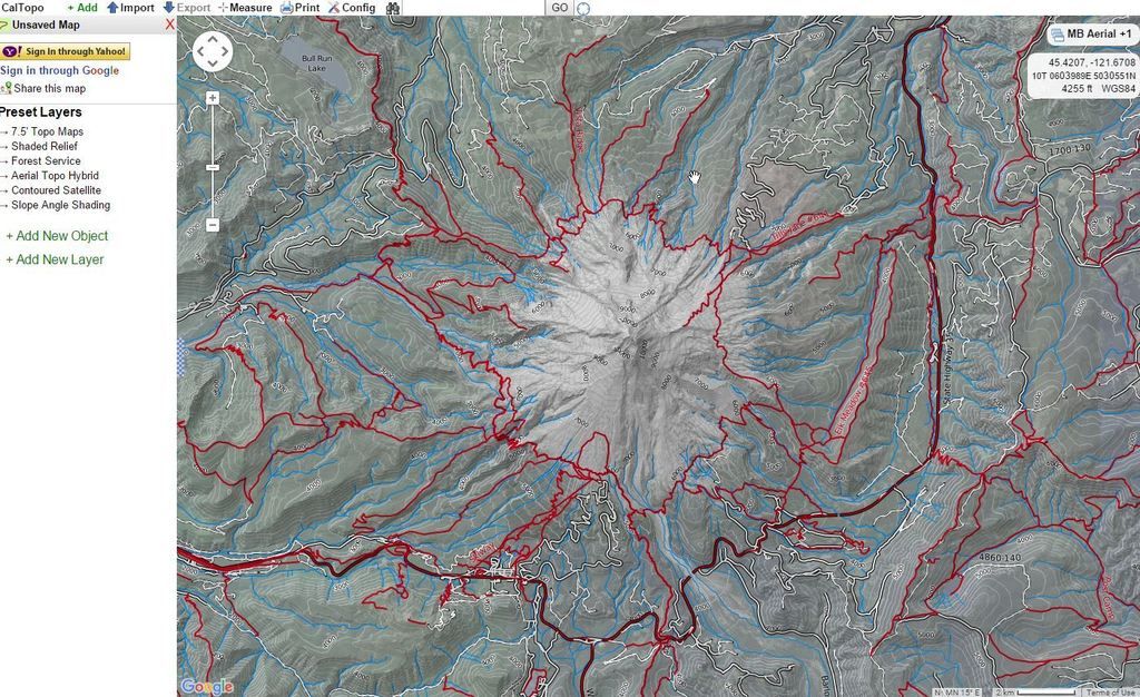
http://caltopo.com/map.html#ll=45.35944 ... b=mba&a=wx
Caltopo - Pimp Your Topo
"I arise in the morning torn between a desire to improve the world and a desire to enjoy the world. This makes it hard to plan the day.”
― E.B. White
― E.B. White
- retired jerry
- Posts: 14425
- Joined: May 28th, 2008, 10:03 pm
Re: Caltopo - Pimp Your Topo
where did the trail layers come from
I see you have the Mountaineer Trail that loops above Timberline Lodge
I see the Yocum Ridge Trail ends at the viewpoint looking over the Sandy, and doesn't continue to the ridge proper
Must be the official Forest Service definition
The McNeil Point trail goes to the shelter and then continues up McNeil Point ridge, is that an official trail???
I believe this is stage #8 on the Peabody scale?
Re: Caltopo - Pimp Your Topo
I don't know what definition they are using for the trail layer, but the official Forest Service definition is a good guess.retired jerry wrote:where did the trail layers come from......
...I believe this is stage #8 on the Peabody scale?
...And yes, my post is a stage #7 and yours would be a stage #8.
"I arise in the morning torn between a desire to improve the world and a desire to enjoy the world. This makes it hard to plan the day.”
― E.B. White
― E.B. White
- kaltbluter
- Posts: 397
- Joined: June 2nd, 2014, 10:36 am
Re: Caltopo - Pimp Your Topo
It looks like the "Cycle Map" layer on openstreetmap.org.retired jerry wrote:where did the trail layers come from
Re: Caltopo - Pimp Your Topo
I believe Matt is slowly transitioning stuff to a paid model by the way, so take advantage for free while you can
Re: Caltopo - Pimp Your Topo
I love that site, and have used it extensively over the years. I have been staring at the MB Topo layer around Mt Hood all morning. I think Max is correct about the open cycle data. I have been using open cycle in conjunction w/ USGS for a long time, but on different maps, so this a welcome layer addition. Re:pay model, normally that bothers me, but I have no problem w/ paying for caltopo "Pro" as it is such a useful program. It has easily saved me lots of money since I don't have to buy the expensive NF maps w/ old, missing, or irrelevant data. I haven't yet upgraded, but I will if/when required.
"The top...is not the top" - Mile...Mile & a Half
Instagram @pdxstrider
Re: Caltopo - Pimp Your Topo
Yes, MapBuilder Topo is a very significant upgrade for Caltopo, thanks for pointing this out.
It gets rid of a lot of the nonessential information on the USGS base maps (like section lines, sheesh) and has a lot of open source trail maps and other information (like the Palmer chairlift on the southside of Hood, pretty important when you're climbing that mountain, and not showing on the USGS map).
And, a comment on the Caltopo subscription service.
Yes, Caltopo is currently free, and probably 98% of users can continue using it as such.
However, the owner of this site, a very nice guy named Matt Jacobs, has been running this entire site as a side hobby for free up until last fall.
He is publicly said on his blog that he is considered pulling the plug in the entire thing, because it takes too much time.
I can hardly blame him for thinking this way.
Moving to a subscription model will hopefully allow him to be compensated a bit for his work, and hopefully allowing this amazing math resource to be available long into the future.
I encourage anyone here who is using this website to help Matt and subscribe for a mere $20 a year.
(Sheesh, I've got a trails illustrated map of Rainier on my desk right now that I think I paid $12 for . . .)
It would be a damn shame if this website disappeared, your subscription will help keep it around hopefully a long time more.
Re: Caltopo - Pimp Your Topo
I'd argue that... Getting rid of data on a map doesn't necessarily make it better..
Re: Caltopo - Pimp Your Topo
Lurch, that's a good point. Removing data per say does not automatically improve a map.Lurch wrote:I'd argue that... Getting rid of data on a map doesn't necessarily make it better..
But, speaking as a former cartographer, that is the true challenge of the work. When data sets do you remove or diminish in visual prominence, and which do you emphasize?
Contour lines are a good example.
Sure, contour lines show landforms accurately, so a contour interval of 20 feet is better than one of 40 feet, right?
Well, not always. A 20 foot contour interval in the Gorge would show you a map that is entirely brown squiggles and not have room for anything else.
So, you make a cartographic trade off - easy to see the information that you want, while dropping information that is hopefully not important to majority of users.
And, as I said above, the red section lines are pretty useless fore most wilderness users, and that's why they are not visible in many custom map layers and software such as Caltopo.
Re: Caltopo - Pimp Your Topo
There's a fundamental difference between which data to emphasize over which, and removing data entirely. A 40ft contour vs a 20 ft contour is a decision on how much emphasis and accuracy is appropriate for a given map, removing contour lines in general is not an appropriate choice. It is, and would continue to be foolish to remove all T&R references from legitimate maps. If you would like to deemphasize it to the PLC's and quarter corners that would be an acceptable choice. Removing it entirely is not.