These crazy maps show just how much ground roads cover
-
Waffle Stomper

- Posts: 3707
- Joined: May 28th, 2008, 10:03 pm
Re: These crazy maps show just how much ground roads cover
What an interesting post. Thank you.
"When we try to pick out anything by itself, we find it hitched to everything else in the Universe." - John Muir

Re: These crazy maps show just how much ground roads cover
Very cool!
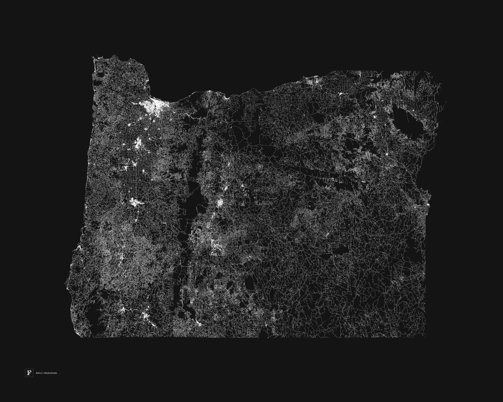
Something's fishy with the Wasco and Sherman county areas on that map. Seems like there's too much roadless area depicted on the map. Is it just me?
Something's fishy with the Wasco and Sherman county areas on that map. Seems like there's too much roadless area depicted on the map. Is it just me?
Believe it or not, I barely ever ride a mountain bike.
Re: These crazy maps show just how much ground roads cover
Charley, those are the Deschutes and John Day river canyons.
Re: These crazy maps show just how much ground roads cover
The Deschutes River canyon has a gravel road on the East bank; not on the above map. There are lots of dirt roads in the Bakeoven Road area. These roads are plainly visible in Google Maps; not on the above map.viking wrote:Charley, those are the Deschutes and John Day river canyons.
In the John Day drainage, there are roads plainly visible on Google Maps just east of OR 218; not on the above map.
This would be fine if the intent of the map was to include only the paved roads. However, since the map depicts the extremely dense network of dirt roads in Lake, Harney and Malheur Counties, and fails to include roads of the same design in Sherman and Wasco Counties, it leads one to a false conclusion: that those areas of Sherman and Wasco Counties are as roadless as the Wilderness preserves in the Cascades Crest. That's patently untrue to anyone who has been there: the land is covered with farms, ranches, and the countless dirt roads used in the service of these businesses.
Since "roadless" is often used as a proxy for "wilderness" (the term and its implications were a big focus of BackpackingLight back in the day, and remain one of my main criterion for interest in an area), accuracy in mapping roadless areas actually means something. Relative to the desert areas of Lake, Harney, and Malheur Counties, Sherman and Wasco are far, far more developed, and less wild. This is why the roadless map is fishy.
Believe it or not, I barely ever ride a mountain bike.

Re: These crazy maps show just how much ground roads cover
I have to agree with Charley. Ive been to the far reaches of SE Oregon and that map shows many more roads than I recall travelling Jeep trails in my Jeep south of Rome all the way to nearly Nevada... roads that I dare say nobody travels on. Then I noticed two bare spots just east (roughly) of Seaside and Tillamook that in reality have so many open gravel roads I dare say everybody travels on, I've driven too...Charley wrote:This would be fine if the intent of the map was to include only the paved roads. However, since the map depicts the extremely dense network of dirt roads in Lake, Harney and Malheur Counties, and fails to include roads of the same design in Sherman and Wasco Counties, it leads one to a false conclusion: that those areas of Sherman and Wasco Counties are as roadless as the Wilderness preserves in the Cascades Crest. That's patently untrue to anyone who has been there: the land is covered with farms, ranches, and the countless dirt roads used in the service of these businesses.
somethings not right.
lightweight, cheap, strong... pick 2