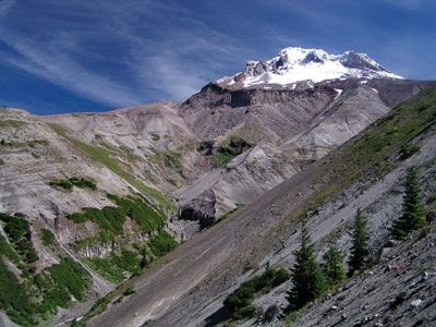
Zigzag Overlook from Hidden Lake Hike
From Oregon Hikers Field Guide
- Start point: Hidden Lake Trailhead
- Ending Point: Zigzag Overlook
- Trail Log: Trail Log
- Distance: 12 miles round-trip
- Elevation gain: 2800 feet
- High Point: 5850 feet
- Difficulty: Difficult
- Seasons: Summer and early Fall
- Family Friendly: No
- Backpackable: Yes
- Crowded: Crowded when you get to the Timberline Trail
Contents |
Description
This is a steep, but much quieter trail option to the Zigzag Overlook and alpine regions on the southwest side of Mount Hood. Much steeper than the more common - and decidedly more busy approach from Timberline Lodge.
The trail starts out as quite a work-out through a fairly young forest. For the first few miles, there are no views to speak of, but in late spring this area comes alive with rhododendron and beargrass blooms. For some, this is the only time of year to enjoy this hike.
The steepness trail does eventually ease up as it approaches Hidden Lake at the 2.0 mile mark. The lake is small, but tranquil and quite pretty in June when the rhodies are at full force. Stop here for a break on a sunny summer day and admire the dragonflies dancing along the downed trees, and watch for salamanders in the shallow, clear water.
From the lake, it's a tough 2 1/2 mile climb in just under 2000 vertical feet before meeting up with the Pacific Crest Trail (PCT) (which is also the Timberline Trail on the west side of the mountain). Most of this climb is in second-growth forest. The views are kept as a surprise as you finally approach the timberline. Coming up on the Hidden Lake Trail junction with the PCT, you'll notice the forest begin to thin out, and the vegetation become more spare. Every footstep kicks up a bit of ancient ash that seems to hang in the air a minute as you pass by.
Finally you meet up with the Timberline Trail (called the "Skyline Trail" on USGS maps). At this point you'll likely come across hikers coming from Timberline Lodge, some 1.3 miles to the East (right). From here you'll head left, in a northeasterly direction following the Timberline Trail about a mile until you hit the Zigzag Overlook
The Zigzag Overlook provides an awe-inspiring view of the magnificent Zigzag Canyon and a classic, postcard view of the Mount Hood summit, with Zigzag Glacier and Illumination Rock in plain view.
More on Zigzag Glacier from www.mounthoodhistory.com:
- The Zigzag Glacier originates in the crater between Crater Rock and Hawkins Cliff below Illumination Rock. This was the first Glacier on Mt. Hood to be trod upon by the white man when Joel Palmer climbed the slope in 1845. The Zigzag Glacier today has receded vastly. It drains into the Zigzag River, Lost Creek, and Rushing Water Creek.
The overlook is your turnaround point. Return back the way you came.
However, there are some other options as well. You could do a loop: continuing along the Timberline Trail past the Zigzag Overlook and down into and across Zigzag Canyon. As you climb back out of the canyon, you'll pick up the Paradise Park Trail at mile 7.7. Heading left from this point, follow the Paradise Park Trail 5.2 miles back down to the Paradise Park Trailhead. The return back to your starting point would be another 0.8 miles along the road. The total mileage for this trip would be about 13.5 miles round trip with 3500' elevation gain. This would be a very strenuous hike! For more information about this option see the Paradise Park Hike.
There are a couple campsites along the Timberline Trail but no drinking water.
Trip Reports
- Search Trip Reports for Zigzag Overlook from Hidden Lake Hike
(Click here to add your own)
Related Discussions / Q&A
- Search Trail Q&A for Zigzag Overlook from Hidden Lake Hike
(Click here to ask a question or start a conversation)


