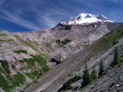
Zigzag Overlook from Hidden Lake Hike
From Oregon Hikers Field Guide
- Starting Point: Hidden Lake Trailhead
- Ending Point: Zigzag Overlook
- Trail Log: Trail Log
- Distance: 12 miles round-trip
- Elevation Gain: 2800 feet
- High Point: 5850 feet
- Difficulty: Difficult
- Seasons: Summer and early Fall
- Family Friendly: No
- Backpackable: No
- Crowded: Crowded when you get to the Timberline Trail
Contents |
Description
The Hidden Lake Trail is another way to get up to the alpine areas on the Southwest side of Mount Hood. A bad thing about this hike, is that towards the end of the hike, after you've gone most of the distance and all the elevation gain, you reach hoardes of tourists that have wandered off from nearby Timberline Lodge. Some people would be put off by this.
The trail is steep, long, and without many views.
At mile 2 you reach non-descript Hidden Lake.
When you reach the Timberline Trail which is also the Pacific Crest Trail on this side of the mountain, you are 1.3 miles from Timberline Lodge to the right.
Go left on the Timberline Trail 1 mile to the Zigzag Overlook that provides excellent views of Mount Hood. This is the end of this hike, go back the way you came.
There are a couple campsites along the Timberline Trail but no drinking water.
You could do a loop - continue along the Timberline Trail down into the Zigzag Canyon and then back up to the Paradise Park Trail at mile 7.7. Take a left on the Paradise Park Trail and go down 5.2 miles to Paradise Park Trailhead. Then walk 0.8 miles back up the road to your starting point - 13.5 miles round trip 3500' elevation gain - this would be a very strenuous hike. See Paradise Park Hike.
Maps
Trip Reports
(Click here to add your own)
Related Conversations / Q&A
(Click here to ask a question or start a conversation)


