Difference between revisions of "Zigzag Overlook"
From Oregon Hikers Field Guide
(Add hike ring) |
(Adjust coords) |
||
| Line 20: | Line 20: | ||
** {{Hike ring|trailhead=Timberline Lodge Trailhead|hike=Paradise Park from Timberline Lodge Hike|log=Paradise Park from Timberline Lodge Hike/Log|previous=Pacific Crest-Hidden Lake Trail Junction|next=Zigzag River Crossing}} | ** {{Hike ring|trailhead=Timberline Lodge Trailhead|hike=Paradise Park from Timberline Lodge Hike|log=Paradise Park from Timberline Lodge Hike/Log|previous=Pacific Crest-Hidden Lake Trail Junction|next=Zigzag River Crossing}} | ||
** {{Hike ring|trailhead=Timberline Lodge Trailhead|hike=Timberline Trail around Mount Hood Hike|log=Timberline Trail around Mount Hood Hike/Log|previous=Pacific Crest-Hidden Lake Trail Junction|next=Zigzag River Crossing}} | ** {{Hike ring|trailhead=Timberline Lodge Trailhead|hike=Timberline Trail around Mount Hood Hike|log=Timberline Trail around Mount Hood Hike/Log|previous=Pacific Crest-Hidden Lake Trail Junction|next=Zigzag River Crossing}} | ||
| − | {{maplinkinfo|latitude=45. | + | |
| − | {{Elevation| | + | {{maplinkinfo|latitude=45.3423|longitude=-121.7409}} |
| + | {{Elevation|5460 feet}} | ||
=== Description === | === Description === | ||
| Line 36: | Line 37: | ||
=== More Links === | === More Links === | ||
| − | |||
* [http://adamschneider.net/photos/2005-07-tl/ Wildflower photos on AdamSchneider.net] | * [http://adamschneider.net/photos/2005-07-tl/ Wildflower photos on AdamSchneider.net] | ||
* [http://www.mounthoodhistory.com/mhhnatural.html www.mounthoodhistory.com] | * [http://www.mounthoodhistory.com/mhhnatural.html www.mounthoodhistory.com] | ||
Revision as of 20:22, 11 June 2016
- Hikes to this location:
- Zigzag Overlook from Timberline Lodge Hike (TH | <— —> | LOG)
- Zigzag Overlook from Hidden Lake Hike (TH | <— —> | LOG)
- Hikes including this location:
- Weather forecast: NWS/NOAA
- Maps: Oregon Hikers Maps Google Maps
- Latitude, Longitude: 45.3423, -121.7409
- Elevation: 5460 feet
Description
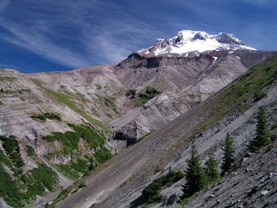
The Zigzag Overlook provides an awe-inspiring view of the magnificent Zigzag Canyon and a classic, postcard view of the Mount Hood summit, with the Zigzag Glacier and Illumination Rock in plain view. It's only 2.2 miles from Timberline Lodge so it's not uncommon to see droves of casual visitors hiking along the Timberline Trail to this vista. Certainly, on a clear summer day, it is a great, family-friendly hike from the lodge trailhead - and it introduces quite a bit of of the alpine splendor that backpackers and tourists alike come to appreciate.
This point is also a popular resting spot for Pacific Crest Trail thru-hikers and Timberline Trail backpackers, who commonly stop here before descending some 500 feet deep into the canyon, then ascend another 1000 vertical feet back out as they make their way towards Paradise Park. You can see why the canyon traverse turns away most casual hikers!
Looking up from the Zigzag Overlook, you can see the Zigzag Glacier, which is the source of the Zigzag River. The Zigzag River flows into the Sandy River and eventually out to the Columbia (near Troutdale, OR).
From www.mounthoodhistory.com:
- The Zigzag Glacier originates in the crater between Crater Rock and Hawkins Cliff below Illumination Rock. This was the first glacier on Mt. Hood to be trod upon by the white man when Joel Palmer climbed the slope in 1845. The Zigzag Glacier today has receded vastly. It drains into the Zigzag River, Lost Creek, and Rushing Water Creek.
There an off-trail route that can give you a more up-close-and-personal view of the glacier and the rest of the uphill geologic features. It is a difficult, unmaintained footpath up and across to a point at 8000 foot elevation. The trail switchbacks back down towards Mississippi Head, and eventually back down toward Paradise Park. It is not a recommended route except for experienced hikers, - and then only in optimum weather conditions.
More Links


