

Difference between revisions of "Winter and Spring Backpacking"
From Oregon Hikers Field Guide
Retiredjerry (Talk | contribs) |
|||
| (21 intermediate revisions by 3 users not shown) | |||
| Line 1: | Line 1: | ||
| − | + | [[Category:Information page]] | |
| − | Most people consider backpacking something for just the summer, but winter and spring offer many opportunities. | + | Most people consider backpacking something for just the summer, but winter and spring offer many opportunities. The weather can be bad and snow closes many hikes, but it is possible to find good places to go backpacking. The lack of other people makes up for some of these difficulties. Even places that are very popular in the summer can be deserted in the winter. |
| − | There are two problems. | + | There are two problems. If it's raining all the time, even with the best gear, it's difficult to have fun. And if there's snow, it's difficult to find where the trail is. If the snow is soft, your feet sink in although skis or snowshoes help; if the snow is hard, it can be difficult where there are steep slopes. |
| + | |||
| + | We're not talking about snow camping here, which is a totally different subject. For that you need warmer gear, snowshoes or skis, white gas, or an inverted canister stove. | ||
| + | |||
| + | <b>Some good winter hikes:</b> | ||
| + | * [https://www.oregonhikers.org/field_guide/Deschutes_River_Hike Deschutes River]: This route is on the east side of the Cascades, where it's much drier, and it's at a low elevation so there's not a lot of snow. There are times when this is brutally cold or it's impossible to get to because the Columbia Gorge is icy, so consult weather reports. | ||
| + | * [https://www.oregonhikers.org/field_guide/Eagle_Creek_to_Tunnel_Falls_Hike Eagle Creek]: The trail is at a lower elevation, so it's usually snow free. This can be overrun with people if the weather is at all nice. There are places where water drips down from up above and can form impassible ice sheets. | ||
| + | * [https://www.oregonhikers.org/field_guide/Salmon_River_Traverse_Hike Salmon River]: This trail is usually snow free in the spring. The lower section is usally an eight-mile snow-free trip that can be extended further by adding the Old Salmon River Trail Section. | ||
| + | * [https://www.oregonhikers.org/field_guide/Ozette_to_Rialto_Beach_Hike Washington Coast: Olympics]: The coast is usually snow free. It can be very rainy and stormy, so consult weather reports. You generally have to time it with tides, so there are about seven good days, then seven bad days. Consult tide tables. It's about six hours from Portland. | ||
| + | * [https://www.oregonhikers.org/field_guide/Siouxon_Creek_Hike Siouxon Creek]: This is a low elevation forested canyon hike, but there may be snow blocking the roads during the winter months. | ||
| + | * [http://www.fs.usda.gov/recarea/willamette/recreation/bicycling/recarea/?recid=4479&actid=24 McKenzie River Trail]: Portions of this trail are open in to the winter. It's also used by mountain bikers. The trail is 26 miles one way. | ||
| + | * [https://www.oregonhikers.org/field_guide/Middle_Metolius_River_Hike Metolius River Trail]: This trail is fairly low elevation, so it should be accessible around late March. This is east of the Cascades, so it's drier than Portland, but because it isn't that far east, it's not as dry as, for example, the Deschutes River. | ||
| + | * Trails in the Oregon Badlands Wilderness near Bend may be snow free or have a light dusting. | ||
| + | * [https://www.oregonhikers.org/field_guide/Rogue_River_Hike Rogue River Trail]: The Rogue's low elevation canyon is open almost all the time year-round. It's 41 miles one way. It's about a 4.5 hour drive from Portland. | ||
| + | * [https://www.oregonhikers.org/field_guide/Illinois_River_Hike Illinois River Trail]: This route is about 30 miles one-way along a low-elevation canyon in the Siskiyous. | ||
| + | * [https://www.oregonhikers.org/field_guide/Mill_Creek_Wilderness_Loop_Hike Mill Creek Wilderness]: This is east of the Cascades, so it's drier, but it's at a little higher elevation, so it's snowy until March or so. Also, because of the elevation, it's not as dry as lower down on the Deschutes. There are other possibilities in the Ochocos. | ||
| + | |||
| + | |||
| + | <b>Some spring backpacks - snow melts off April through June or so:</b> | ||
| + | * [https://www.oregonhikers.org/field_guide/Ramona_Falls_Loop_Hike Ramona Falls]: Ramona Falls is fairly low elevation, but crossing the Sandy River can be tricky. Earlier in the season, maybe you can find somewhere between Lolo Pass Road and the Ramona Falls Trailhead, when there's still snow preventing cars. They often close the road at the Sandy River. | ||
| + | * [https://www.oregonhikers.org/field_guide/East_Zigzag_Mountain_Hike East Zigzag Mountain and Burnt Lake]: Earlier maybe you're lucky getting to Burnt Lake. At some point, it's possible to get up to East Zigzag Mountain. There are other similar routes on Zigzag Ridge. | ||
| + | * [https://www.oregonhikers.org/field_guide/Wahtum_Lake_via_Herman_Creek_Hike Herman Creek]: Herman Creek is another low elevation river canyon, but a little higher than Eagle Creek. Also, it's much less popular. Depending on the snow level, you may be able get up Nick Eaton Ridge, Indian Point, and Wahtum Lake,... | ||
| + | * [https://www.oregonhikers.org/field_guide/Badger_Creek_Hike Badger Creek]: Badger Creek is a mid-elevation river canyon, maybe open in April. It's on the east side of the Cascades, so it's drier than Portland. The roads are always "open" but may be snow covered. It's easier from Tygh Valley. If there isn't too much snow, maybe you can get all the way to Badger Lake or some of the ridges above. | ||
| + | * A lot of trails in southern Oregon's Siskiyou Mountains will become accessible in the spring. | ||
| + | * Trails in the Aldrich Mountains and the lower elevations in the Strawberry Mountain Wilderness are opening up. | ||
| + | * [https://www.oregonhikers.org/field_guide/Lower_Wenaha_River_Hike Wenaha-Tucannon Wilderness]: Drive to Troy, Oregon, and hike up the Wenaha River. The trail is usually open in April or May. Northern areas near Dayton are open in June. Early season is best before it dries up. | ||
| + | * [http://www.oregonhikers.org/forum/viewtopic.php?f=8&t=24134 Blue Mountains]: Lower trailheads leading into the North Fork Umatilla Wilderness, and up the South Fork Walla Walla River canyon are opening up. | ||
| + | * Wallowa Mountains: Lower river valleys with trails, e.g. Bear Creek, Hurricane Creek, McCully Creek, South Fork Imnaha River, will become accessible in late spring. | ||
| + | |||
| + | |||
| + | <b>Other longer options that require more individualized planning:</b> | ||
| + | * [https://www.oregonhikers.org/field_guide/North_Fork_John_Day_River_Loop_Hike North Fork John Day Wilderness]: You will need to ford rivers, but the area is mostly open to backpacking by May. | ||
| + | * Hells Canyon/Snake River Trail: About six hours from Portland. | ||
| + | * Pueblo Mountains, Trout Creek Mountains, Owyhee Canyon area: Off-trail backpacking through sagebrush. Some of it (Pueblos) marked as the Oregon Desert Trail. Good navigating skills needed. The desert is cooler and green, but there may be furious thunderstorms. | ||
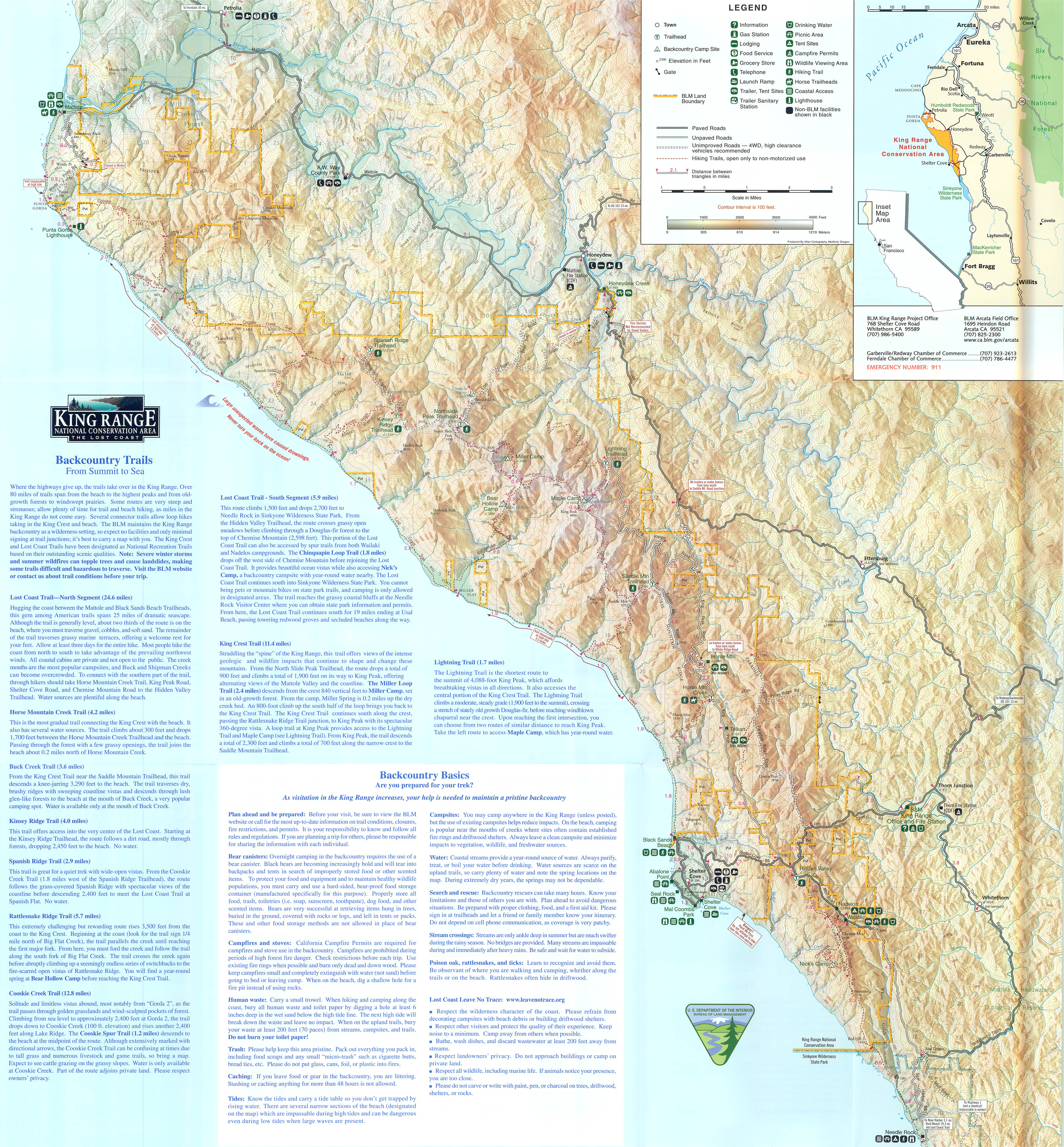
| + | * The Lost Coast: About nine hours from Portland, in Northern California. [http://www.igorkoltunov.com/maps/lostcoast/KingRange_LostCoast_small.jpg igorkoltunov map] | ||
| + | * [http://www.nps.gov/olym/planyourvisit/wilderness-trail-conditions.htm Olympic National Park]: Many of the river valleys are fairly snow free, including the [https://www.wta.org/go-hiking/hikes/bogachiel-river Bogachiel], [https://www.wta.org/go-hiking/hikes/main-fork-dosewallips-river Dosewallips], [https://www.wta.org/go-hiking/hikes/duckabush-river Duckabush], [https://www.wta.org/go-hiking/hikes/hoh-river-trail-to-five-mile-island Hoh], [https://www.wta.org/go-hiking/hikes/queets-river Queets], and [https://www.wta.org/go-hiking/hikes/north-fork-skokomish-river North Fork Skokomish] rivers. The trail up the East Fork Quinault River to [https://www.wta.org/go-hiking/hikes/enchanted-valley Enchanted Valley] is probably the most popular river route in the Olympics. | ||
| − | |||
| − | |||
In order to decide where to go, you need good weather information: | In order to decide where to go, you need good weather information: | ||
| − | * [http://www.nwrfc.noaa.gov/weather/10_day.cgi NOAA 10 day weather forecast] | + | * [http://www.nwrfc.noaa.gov/weather/10_day.cgi NOAA 10 day weather forecast]: Has maps showing precipitation amount and temperature for 10 days |
| − | * [http://forecast.weather.gov/MapClick.php?CityName=Portland&state=OR&site=PQR&textField1=45.447&textField2=-122.767 NOAA 7 day forecast] | + | * [http://forecast.weather.gov/MapClick.php?CityName=Portland&state=OR&site=PQR&textField1=45.447&textField2=-122.767 NOAA 7 day forecast]: What's good about this is you can scroll around on the map and select a location to get the forecast for that spot |
| − | * [ | + | * [https://radar.weather.gov/ NOAA Radar]: Shows where the rain was in the last few hours - better for deciding when to go out for a walk |
| − | * [http://www.nohrsc.noaa.gov/interactive/html/map.html?ql=station&zoom=&loc=45.382+N%2C+122.315+W&var=ssm_depth&snap=1&o9=1&o12=1&o13=1&lbl=m&o7=1&mode=pan&extents=us&min_x=-122.31666666667&min_y=44.991666666667&max_x=-121.38333333333&max_y=45.691666666667&coord_x=-121.85&coord_y=45.341666666666995&zbox_n=&zbox_s=&zbox_e=&zbox_w=&metric=0&bgvar=dem&shdvar=shading&width=600&height=450&nw=600&nh=450&h_o=0&font=0&js=1&uc=0 NOAA snow model] | + | * [http://www.nohrsc.noaa.gov/interactive/html/map.html?ql=station&zoom=&loc=45.382+N%2C+122.315+W&var=ssm_depth&snap=1&o9=1&o12=1&o13=1&lbl=m&o7=1&mode=pan&extents=us&min_x=-122.31666666667&min_y=44.991666666667&max_x=-121.38333333333&max_y=45.691666666667&coord_x=-121.85&coord_y=45.341666666666995&zbox_n=&zbox_s=&zbox_e=&zbox_w=&metric=0&bgvar=dem&shdvar=shading&width=600&height=450&nw=600&nh=450&h_o=0&font=0&js=1&uc=0 NOAA snow model]: Shows the amount of snow on the ground. This is centered on Mt Hood, but you can scroll around anywhere in the U.S. One problem is it gives the amount for about 1 square mile areas, so it's not going to be very good for narrow ridges, but you can take that into account. And, it's a model so it's only so accurate, but it gives you an idea. |
| + | * [https://www.fs.usda.gov/Internet/FSE_DOCUMENTS/fseprd1045012.html Current Snow Depth]: Starts at Lake Tahoe, but you can navigate up to Oregon from there. | ||
| − | |||
| − | |||
=== Contributors === | === Contributors === | ||
| − | * [[User:retiredjerry]] | + | * [[User:retiredjerry|retiredjerry]] |
Latest revision as of 23:37, 27 December 2023
Most people consider backpacking something for just the summer, but winter and spring offer many opportunities. The weather can be bad and snow closes many hikes, but it is possible to find good places to go backpacking. The lack of other people makes up for some of these difficulties. Even places that are very popular in the summer can be deserted in the winter.
There are two problems. If it's raining all the time, even with the best gear, it's difficult to have fun. And if there's snow, it's difficult to find where the trail is. If the snow is soft, your feet sink in although skis or snowshoes help; if the snow is hard, it can be difficult where there are steep slopes.
We're not talking about snow camping here, which is a totally different subject. For that you need warmer gear, snowshoes or skis, white gas, or an inverted canister stove.
Some good winter hikes:
- Deschutes River: This route is on the east side of the Cascades, where it's much drier, and it's at a low elevation so there's not a lot of snow. There are times when this is brutally cold or it's impossible to get to because the Columbia Gorge is icy, so consult weather reports.
- Eagle Creek: The trail is at a lower elevation, so it's usually snow free. This can be overrun with people if the weather is at all nice. There are places where water drips down from up above and can form impassible ice sheets.
- Salmon River: This trail is usually snow free in the spring. The lower section is usally an eight-mile snow-free trip that can be extended further by adding the Old Salmon River Trail Section.
- Washington Coast: Olympics: The coast is usually snow free. It can be very rainy and stormy, so consult weather reports. You generally have to time it with tides, so there are about seven good days, then seven bad days. Consult tide tables. It's about six hours from Portland.
- Siouxon Creek: This is a low elevation forested canyon hike, but there may be snow blocking the roads during the winter months.
- McKenzie River Trail: Portions of this trail are open in to the winter. It's also used by mountain bikers. The trail is 26 miles one way.
- Metolius River Trail: This trail is fairly low elevation, so it should be accessible around late March. This is east of the Cascades, so it's drier than Portland, but because it isn't that far east, it's not as dry as, for example, the Deschutes River.
- Trails in the Oregon Badlands Wilderness near Bend may be snow free or have a light dusting.
- Rogue River Trail: The Rogue's low elevation canyon is open almost all the time year-round. It's 41 miles one way. It's about a 4.5 hour drive from Portland.
- Illinois River Trail: This route is about 30 miles one-way along a low-elevation canyon in the Siskiyous.
- Mill Creek Wilderness: This is east of the Cascades, so it's drier, but it's at a little higher elevation, so it's snowy until March or so. Also, because of the elevation, it's not as dry as lower down on the Deschutes. There are other possibilities in the Ochocos.
Some spring backpacks - snow melts off April through June or so:
- Ramona Falls: Ramona Falls is fairly low elevation, but crossing the Sandy River can be tricky. Earlier in the season, maybe you can find somewhere between Lolo Pass Road and the Ramona Falls Trailhead, when there's still snow preventing cars. They often close the road at the Sandy River.
- East Zigzag Mountain and Burnt Lake: Earlier maybe you're lucky getting to Burnt Lake. At some point, it's possible to get up to East Zigzag Mountain. There are other similar routes on Zigzag Ridge.
- Herman Creek: Herman Creek is another low elevation river canyon, but a little higher than Eagle Creek. Also, it's much less popular. Depending on the snow level, you may be able get up Nick Eaton Ridge, Indian Point, and Wahtum Lake,...
- Badger Creek: Badger Creek is a mid-elevation river canyon, maybe open in April. It's on the east side of the Cascades, so it's drier than Portland. The roads are always "open" but may be snow covered. It's easier from Tygh Valley. If there isn't too much snow, maybe you can get all the way to Badger Lake or some of the ridges above.
- A lot of trails in southern Oregon's Siskiyou Mountains will become accessible in the spring.
- Trails in the Aldrich Mountains and the lower elevations in the Strawberry Mountain Wilderness are opening up.
- Wenaha-Tucannon Wilderness: Drive to Troy, Oregon, and hike up the Wenaha River. The trail is usually open in April or May. Northern areas near Dayton are open in June. Early season is best before it dries up.
- Blue Mountains: Lower trailheads leading into the North Fork Umatilla Wilderness, and up the South Fork Walla Walla River canyon are opening up.
- Wallowa Mountains: Lower river valleys with trails, e.g. Bear Creek, Hurricane Creek, McCully Creek, South Fork Imnaha River, will become accessible in late spring.
Other longer options that require more individualized planning:
- North Fork John Day Wilderness: You will need to ford rivers, but the area is mostly open to backpacking by May.
- Hells Canyon/Snake River Trail: About six hours from Portland.
- Pueblo Mountains, Trout Creek Mountains, Owyhee Canyon area: Off-trail backpacking through sagebrush. Some of it (Pueblos) marked as the Oregon Desert Trail. Good navigating skills needed. The desert is cooler and green, but there may be furious thunderstorms.
- The Lost Coast: About nine hours from Portland, in Northern California. igorkoltunov map
- Olympic National Park: Many of the river valleys are fairly snow free, including the Bogachiel, Dosewallips, Duckabush, Hoh, Queets, and North Fork Skokomish rivers. The trail up the East Fork Quinault River to Enchanted Valley is probably the most popular river route in the Olympics.
In order to decide where to go, you need good weather information:
- NOAA 10 day weather forecast: Has maps showing precipitation amount and temperature for 10 days
- NOAA 7 day forecast: What's good about this is you can scroll around on the map and select a location to get the forecast for that spot
- NOAA Radar: Shows where the rain was in the last few hours - better for deciding when to go out for a walk
- NOAA snow model: Shows the amount of snow on the ground. This is centered on Mt Hood, but you can scroll around anywhere in the U.S. One problem is it gives the amount for about 1 square mile areas, so it's not going to be very good for narrow ridges, but you can take that into account. And, it's a model so it's only so accurate, but it gives you an idea.
- Current Snow Depth: Starts at Lake Tahoe, but you can navigate up to Oregon from there.