Difference between revisions of "Sutton Mountain Hike"
From Oregon Hikers Field Guide
Justpeachy (Talk | contribs) |
(Add link) |
||
| (4 intermediate revisions by 2 users not shown) | |||
| Line 1: | Line 1: | ||
| − | [[Category: | + | [[Category:Eastern Oregon]] |
| + | [[Category:Bureau of Land Management]] | ||
[[Category:Moderate Hikes]] | [[Category:Moderate Hikes]] | ||
| + | [[Category:Wildflower Hikes]] | ||
| + | [[Category:Viewpoint Hikes]] | ||
[[Category:Hikes]] | [[Category:Hikes]] | ||
| + | |||
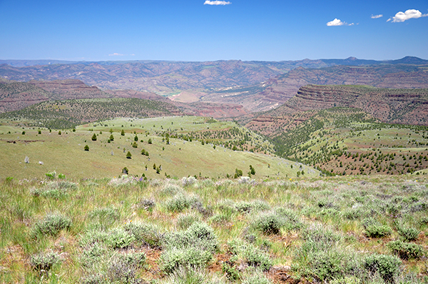
| + | [[Image:Suttonview.jpg|thumb|600px|The view from Sutton Mountain ''(Cheryl Hill)'']] | ||
| + | [[Image:Suttonhedgehog.jpg|thumb|400px|Hedgehog cactus blooming on Sutton Mountain "((Cheryl Hill)"]] | ||
| + | [[Image:SuttonMountainMap.jpg|thumb|400px|Sutton Mountain map]] | ||
{{Start point|Sutton Mountain Trailhead}} | {{Start point|Sutton Mountain Trailhead}} | ||
| Line 15: | Line 22: | ||
* Crowded: No | * Crowded: No | ||
| − | |||
| − | |||
=== Hike Description === | === Hike Description === | ||
| Line 37: | Line 42: | ||
=== Fees, Regulations, etc. === | === Fees, Regulations, etc. === | ||
| − | |||
{{TripReports|Sutton Mountain Hike}} | {{TripReports|Sutton Mountain Hike}} | ||
| Line 44: | Line 48: | ||
=== Guidebooks that cover this hike === | === Guidebooks that cover this hike === | ||
| − | * ''100 Hikes / Travel Guide Eastern Oregon | + | * ''100 Hikes /Travel Guide: Eastern Oregon'' by William L. Sullivan |
| − | + | ||
=== More Links === | === More Links === | ||
| − | |||
* [https://www.blm.gov/or/districts/prineville/recreation/files/sutton_mountain.pdf Sutton Mountain area map from BLM] | * [https://www.blm.gov/or/districts/prineville/recreation/files/sutton_mountain.pdf Sutton Mountain area map from BLM] | ||
* [https://onda.org/where-we-work/john-day/sutton-mountain-recreation-map Sutton Mountain Recreation map from ONDA] | * [https://onda.org/where-we-work/john-day/sutton-mountain-recreation-map Sutton Mountain Recreation map from ONDA] | ||
* [https://onda.org/publications/brochures/sutton-mountain-visitors-guide-john-day-region Sutton Mountain visitor's guide] | * [https://onda.org/publications/brochures/sutton-mountain-visitors-guide-john-day-region Sutton Mountain visitor's guide] | ||
| + | * [https://www.trailkeepersoforegon.org/hike-season-sutton-mountain/#more-1253 Hike of the Season: Sutton Mountain (Trailkeepers of Oregon)] | ||
| + | |||
=== Contributors === | === Contributors === | ||
* [[User:justpeachy|justpeachy]] (creator) | * [[User:justpeachy|justpeachy]] (creator) | ||
Revision as of 21:44, 18 July 2018
- Start point: Sutton Mountain Trailhead
- End point: Sutton Mountain
- Trail Log: Trail Log
- Hike Type: Out-and-back
- Distance: 7.5 miles
- Elevation gain: 1600 feet
- Difficulty: Moderate
- Seasons: Spring and Fall
- Family Friendly: Yes
- Backpackable: Yes, but no water available
- Crowded: No
Contents |
Hike Description
This hike in the Sutton Mountain Wilderness Study Area is great in the spring when the wildflowers are blooming. It follows an old road for the entire way except the last tiny bit. Even though it's technically a road hike, it doesn't feel like one most of the time. Avoid this hike in summer when the temperatures are scorching.
From the trailhead, walk north along a cow lane that follows a fenceline, heading towards a gate in the trees. Walk around the gate and continue following the lane, which is rough and chewed-up from cows. The path turns sharply left just before an area of private barns and buildings.
Follow the old grassy road as it heads uphill beside a dry gully. Follow the road as it curves to the right, crossing the dry gully, and doubling back as it continues climbing. In May look for lupine, milk vetch, and other wildflowers blooming here.
The road flattens out and curves to the left and the views start really opening up. The road stays level for awhile and on clear days you can see the tip of Mt. Hood off in the distance. Wildflowers are abundant along this stretch in the spring.
The road passes through a gateway (there is no longer an actual gate). The path may get a bit faint here, but ahead is a fence that heads uphill to the left. On the other side of that fence the road turns sharply uphill. You will also see a path going straight, which you are welcome to explore, but this hike will take you to the left. The road may be faint and pretty grassy at times through this stretch as you hike up, but if you look carefully it's there.
You will see two humps of Sutton Mountain ahead of you. The one on the right is the true summit. As you approach, the old road does not actually go up there but skirts along the shoulder of the slope. To get up to the summit you will need to go cross-country. Up at the top are a few hardy juniper trees and an incredible view that includes distant Mt. Jefferson, Mt. Hood, and Mt. Adams. You can also see the Painted Hills below the summit to the west. If your timing is right in the spring you will also see numerous hedgehog cactus in bloom up here.
Return the way you came.
Maps
- Maps: Hike Finder
Fees, Regulations, etc.
Trip Reports
- Search Trip Reports for Sutton Mountain Hike
Related Discussions / Q&A
- Search Trail Q&A for Sutton Mountain Hike
Guidebooks that cover this hike
- 100 Hikes /Travel Guide: Eastern Oregon by William L. Sullivan
More Links
- Sutton Mountain area map from BLM
- Sutton Mountain Recreation map from ONDA
- Sutton Mountain visitor's guide
- Hike of the Season: Sutton Mountain (Trailkeepers of Oregon)
Contributors
- justpeachy (creator)


