Shore Acres Loop Hike
From Oregon Hikers Field Guide
- Start point: Sunset Bay Trailhead
- Ending Point: Simpson Beach
- Trail Log:
- Hike Type: Lollipop loop
- Distance: 4.7 miles
- Elevation gain: 230 feet
- High Point: 100 feet
- Difficulty: Easy
- Seasons: All year
- Family Friendly: Yes
- Backpackable: No
- Crowded: Yes, on weekends and in summer
|
Contents |
Hike Description
A series of state properties, four in all, run together on a section of rugged coastline southwest of Charleston in Coos County. The hike described here begins at Sunset Bay State Park but soon crosses the boundary into Shore Acres State Park. This section of the Oregon Coast Trail passes through forest, deposits you in a couple of small coves, and travels along colorful clifftops with spectacular views. The botanical gardens at Shore Acres are a highlight of the outing as are views to the Cape Arago Lighthouse on Chief's Island. This hike can be combined with the Cape Arago Loop Hike for a longer excursion. Dogs are not permitted in the Shore Acres Botanical Gardens.
At Sunset Bay State Park, a sign on the east side of the parking area commemorates the beginning here of the first transcontinental balloon journey on October 4th, 1973. The balloon, piloted by billionaire Malcolm Forbes and his son Bobby, ended at Chesapeake Bay, Virginia, on November 6th.
Cross the footbridge over Big Creek to the right of the restrooms. A short spur leads to the mouth of the creek, where you can see the sprawling roots of ancient spruce trees, the remains of a forest that dropped to sea level during one of the great Cascade earthquakes 1,200 years ago. Switchback up through a forest of Sitka spruce, salad, evergreen huckleberry, sword fern, and deer fern. The trail passes along the edge of the Norton Gulch Group Camp. At half a mile, you will reach an unsigned T-junction. Turn right on a short spur trail to visit a viewpoint with a bench and a view across the mouth of Sunset Bay to Qochyax Island, formerly Squaw Island, with its forest of dead trees. Retrace your steps back to the main trail and continue south. Numerous little viewpoints allow you to see the ocean, coves, and rock formations, and eventually the Cape Arago Lighthouse to the north. Looking south, you'll get glimpses of Norton Cove, guarded by a massive block of harder sandstone that was breached by the ocean to create the little inlet.
At the one-mile mark, the trail reaches the entrance to the grassy Norton Gulch Group Camp area to the left and the paved park road. Follow the short steep trail down into Norton Gulch and visit the rocky beach in the cove. Return to the road, and walk along it for about 220 yards. Just before the guard rail ends, the trail heads back into the woods on your right.
The trail remains close to the road and soon passes below a small roadside parking area. At a junction, go right for a view towards the Cape Arago Lighthouse. You'll turn away from the road into the forest on what was once the driveway for the Simpson mansion at Shore Acres. Several hundred feet down this old road, at an unsigned junction take the trail on the right.
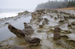
The trail soon follows the cliff edge, getting more views of the lighthouse, and swings back around to the south. Many viewpoints offer dramatic views, although fences and barriers are scarce so it is very important to hold on to little ones and keep pets on a leash. The dramatic rock formations you see are part of the 40 million-year-old Coaledo Formation, hardened sediments from an ancient Eocene Epoch delta. The rocks are tilted at angles because of the collision of the Juan De Fuca and North American plates. Look for honeycombing, or tafoni, resulting from salt weathering. You can also see examples of concretions, cannonball-like structures formed when calcite crystallizes around organic matter in the sand.
The trail curves and winds away from the cliff and into dense thickets. At a T-junction turn right. The trail descends some steps into a gully, and climbs back out via more steps. The trail skirts a cliff with more cool rock formations to your right. Cross the old tennis courts to another viewpoint with a bench where you can see across to the observatory. Continue on the trail, which soon reaches the parking area for Shore Acres State Park. Stay to the right to check out the Observatory, which stands on the site where Louis J. Simpson built a mansion in 1908 for his wife Cassie. She died in April 1921, and just three months later the mansion was destroyed in a fire. Simpson built a new home on the site in 1927, which was sold to state in 1942. The house, aged beyond its years by winter storms, was razed in 1948 and all signs of it are gone. The Observatory is a good place to get out of the wind, and interpretive signs inside explain the cultural and natural history of the area. The rocks of Simpson Reef, the latest seal/sea lion haulout spot on the Oregon Coast, are visible to the south. This is also a good whale watching perch: December-January for the southern migration of gray whales and March-April for the return to their Alaska feeding grounds.
Keep hiking south and come to a junction with a trail to the botanical garden. Stay right for Simpson Beach, and pass a gate to the garden. A flight of steps leads down to the small beach in another circular cove. The Oregon Coast Trail continues left across a footbridge over First Creek to reach Cape Arago (See the Cape Arago Loop Hike).
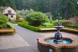
Heading back, and enter the garden gate to check out the botanical gardens. Louis J. Simpson hired landscape gardener David Masterson to design this English-style garden with a Japanese-style pond, gravel paths, layers of shrubbery, and beds of flowers. There are a few blooms even in the winter months, but spring is the time to see tulips and rhododendrons, while roses and dahlias put on a colorful display in the summer. Between Thanksgiving and New Year's Eve the garden is decked out with 350,000 LED lights. The only original building from the Simpson days is the Garden House near the columned gazebo.
To return to your car, pass through the main entrance to the garden at the visitor center, shaded by statuesque Monterey cypresses and pines. Walk across an open field towards the entrance booth. Just west of the concrete entrance booth, pick up the trail heading north into the woods. This is the former Simpson driveway. You will pass some concrete pillars. Soon you will be back at the roadside pullout where you can retrace your steps on the trail back to the Sunset Bay Day Use Area. Walking back along the road is not recommended as there are several spots with no shoulder.
Fees, Regulations, etc.
- No fee is charged at the Sunset Bay Day Use Area, but if you decide to start your hike at Shore Acres you will need to pay a $5 day use fee.
- Sunset Bay: Pets must be physically restrained at all times when not confined in a vehicle. Leashes must be no longer than six feet. All waste must be properly removed.
- Shore Acres: No animals permitted outside of vehicles, with the exception of service animals.
- Campground at Sunset Bay State Park
Maps
Trip Reports
- Search Trip Reports for Shore Acres Loop Hike
Related Discussions / Q&A
- Search Trail Q&A for Shore Acres Loop Hike
- Breaking waves on 4/20: Shore Acres High Surf Advisory
Guidebooks that cover this destination
- Exploring the Oregon Coast Trail by Connie Soper
- 100 Hikes/Travel Guide: Oregon Coast & Coast Range by William L. Sullivan
- Trips & Trails: Oregon by William L. Sullivan
- Oregon Favorites: Trails and Tales by William L. Sullivan
- Hiking Oregon's History by William L. Sullivan
- Hiking Oregon's Geology by Ellen Morris Bishop
- Best Hikes With Kids: Oregon by Bonnie Henderson & Zach Urness
- Hiking the Oregon Coast by Lizann Dunegan
- Hiking Oregon by Lizann Dunegan
- Hike America: Oregon by Lizann Dunegan
- 120 Hikes on the Oregon Coast by Bonnie Henderson
- Day Hiking: Oregon Coast by Bonnie Henderson
- Out Our Back Door: Driving Tours and Day-Hikes in Oregon’s Coos Region by Tom Baake
- Oregon Coast Hikes by Paul M. Williams
- Oregon Coast Trail: Hiking Inn to Inn by Jack D. Remington
- The Oregon Coast Trail Guide by Jon Kenneke (e-book)
- Oregon Coast Camping & Hiking by Tom Stienstra & Sean Patrick Hill
- Oregon Campgrounds Hiking Guide by Rhonda & George Ostertag
- Oregon Hiking by Sean Patrick Hill
- Pacific Northwest Hiking by Scott Leonard & Sean Patrick Hill
- Oregon's Best Coastal Beaches by Dick Trout
- Oregon State Parks: A Complete Recreation Guide by Jan Bannan
More Links
- Sunset Bay State Park (Oregon State Parks)
- Shore Acres State Park (Oregon State Parks)
- Oregon Top 5: Best hikes near Coos Bay (Statesman Journal)
- Sunset Bay State Park (near Coos Bay, Ore.) (Zach’s Adventures)
- Sunset Bay State Park (Oregon.com)
- Sunset Bay to Simpson Reef (Modern Hiker)
- Sunset Bay State Park (Outdoor Project)
- Ancient Spruce Stumps of Sunset Bay (Nature Chronicles)
- “Sunset Bay, Shore Acres and Cape Arago state parks welcome the public to a once private coastal wonderland” (Register-Guard)
- Shore Acres State Park (Friends of Shore Acres)
- Shore Acres Loop Trail (Outdoor Project)
- Shore Acres State Park (Oregon.com)
- Shore Acres (Oregon Adventures)
- Shore Acres State Park (The American Southwest)
- Shore Acres State Park (Outdoor Project)
- “Holiday lights dazzle at Shore Acres, illuminating the Oregon Coast” (Oregon Live)
- Cape Arago Lighthouse (Lighthouse Friends)
- Cape Arago Light (Wikipedia)
- Sunset Bay-Shore Acres-Cape Arago: The Geologic Story (ResearchGate)
Page Contributors
- justpeachy (creator)


