

Rooster Rock (Menagerie Wilderness)
From Oregon Hikers Field Guide
File:Rooster.jpg
Rooster Rock (cfm)

- Hikes to this location:
- Rooster Rock via Trout Creek Trail Hike (TH | <— —> | LOG)
- Rooster Rock Trail Hike (TH | <— —> | LOG)
- Weather forecast: NWS/NOAA
- Maps: Oregon Hikers Maps Google Maps
- Latitude, Longitude: 44.418, -122.3037
- Elevation: 3567 feet
Contents |
Description
Rooster Rock is a common moniker for rock formations with a certain...shape. This Rooster Rock is located in the Menagerie Wilderness, west of Sweet Home. The many pinnacles concentrated in this low elevation, easy to access forest make the area a favorite of climbers. All of the formations have animal names such as Rabbit Ears, Chicken and Turkey Monster.
Trip Reports
- Search Trip Reports for Rooster Rock (Menagerie Wilderness)
(Click here to add your own)
Related Discussions / Q&A
- Search Trail Q&A for Rooster Rock (Menagerie Wilderness)
- NUMBER.aspx Subject of post (5/1/06)
(Click here to ask a question or start a conversation)
Guidebooks that cover this destination
- Hiking Oregon's Wild Areas , by William L. Sullivan
- 100 Hikes in Central Oregon, by William L. Sullivan
More Links
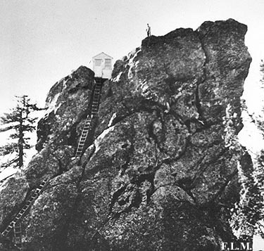
- Historical photo of the former lookout building on Rooster Rock
Contributors
- cfm (creator)