

Difference between revisions of "Rooster Rock (Menagerie Wilderness)"
From Oregon Hikers Field Guide
(Add category) |
|||
| Line 3: | Line 3: | ||
[[Category:Wilderness]] | [[Category:Wilderness]] | ||
[[Category:Geologic Features]] | [[Category:Geologic Features]] | ||
| + | [[Category:Former Lookouts]] | ||
[[Category:Destinations]] | [[Category:Destinations]] | ||
| − | [[Image:Rooster Rock from climber's trail, Menagerie Wilderness.jpg|thumb|260px|Rooster Rock from the climber's trail, Menagerie Wilderness ''( | + | [[Image:Rooster Rock from climber's trail, Menagerie Wilderness.jpg|thumb|260px|Rooster Rock from the climber's trail, Menagerie Wilderness ''(bobcat)'']] |
| − | + | ||
* Hikes to this location: | * Hikes to this location: | ||
Revision as of 01:00, 23 September 2017

- Hikes to this location:
- Weather forecast: NWS/NOAA
- Maps: Oregon Hikers Maps Google Maps
- Latitude, Longitude: 44.4172, -122.3043
- Elevation: 3470 feet
Description
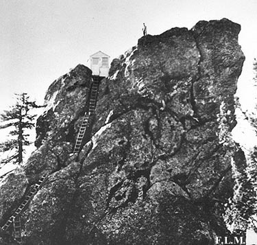
Rooster Rock is a common moniker for rock formations with a certain shape. This Rooster Rock is located in the Menagerie Wilderness, east of Sweet Home. The many pinnacles concentrated in this low elevation forest make the area a favorite of climbers. All of the formations have animal names such as Rabbit Ears, Chicken Rock, and Turkey Monster.
Rooster Rock itself was the site of a precariously perched lookout accessed by a series of ladders bolted to the north face. The cabin where the lookout staff was quartered was located at the Rooster Rock Viewpoint. The lookout stood here from 1927 to 1963, when it was dismantled although there are apparently some remains on top of the rock.
More Links
- Rooster Rock (Menagerie) (Summit Post)
- Historical photo of the former lookout building on Rooster Rock
Contributors
- cfm (creator)