

Pilot Butte Loop Hike
From Oregon Hikers Field Guide


,_Pilot_Butte.jpg)

- Start point: Pilot Butte Trailhead

- End Point: Pilot Butte
- Hike Type: Loop
- Distance: 2.1 miles
- Elevation gain: 470 feet
- High Point: 4,138 feet
- Difficulty: Easy
- Seasons: All year
- Family Friendly: Yes
- Backpackable: No
- Crowded: Yes
Contents |
Description
Pilot Butte is a 190,000 year-old cinder cone, state park, and emblematic feature of the Bend skyline. The nature trail to the top of the butte parallels the road: this allows for a loop option, especially from fall to early spring, when the road is closed to vehicles. The trails here are popular walking and jogging tracks for humans and their canines, so on a nice day, don’t expect much solitude. While the immediate views are of the sprawling, rapidly evolving city, the snow-capped peaks of the central Cascades line the horizon from Mount Hood to the tippy top of Diamond Peak.
Walk past the kiosk at the south end of the parking lot, and take a paved trail that leads past an exercise area. Go right at a junction and, at the next junction, keep straight on an unpaved trail. Where the trail splits, keep left to head up the slope quite steeply among bitterbrush, sagebrush, western juniper, and a few ponderosa pines. Numbered posts mark information points on the nature trail. You’ll pass several benches and get views to the neighborhood park below, a large medical center, and Powell Buttes to the northeast. The trail levels where it passes to the north side of the cinder cone. Now Mount Hood, Mount Jefferson, Three Fingered Jack, and Black Butte are visible. See also if you can make out Smith Rock. Soon, Mount Washington, the Three Sisters, and Mount Bachelor hove into sight, with Bend’s Awbrey Butte the hill across the Deschutes River. At the summit area, interpretive signs are posted around the walled viewing plaza. There are also restrooms here, and a grassy area below the summit offers a landing spot.
To hike down, take the trail back, or to complete a loop, you can walk the wide shoulder beside the summit road. The road views are generally to the east and south. Note that almost every western juniper hosts clumps of the juniper mistletoe parasite. As you get lower, Mount Bachelor, Broken Top, and the Three Sisters come into view again, and you reach the junction with the Road Trail, where you go left. This paved trail will take you back to the parking area.
Fees, Regulations, etc.
- Dogs on leash
Maps
- Maps: Hike Finder
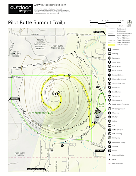
- Pilot Butte Summit Trail, OR (Outdoor Project)
- Adventure Maps: Bend, Oregon, Trail Map
Trip Reports
- Search Trip Reports for Pilot Butte Loop Hike
Related Discussions / Q&A
- Search Trail Q&A for Pilot Butte Loop Hike
Guidebooks that cover this destination
- Day Hiking: Bend and Central Oregon by Brittany Manwill
- Best Easy Day Hikes: Bend & Central Oregon by Lizann Dunegan
- Best Hikes Near Bend by Lizann Dunegan
- Day Hikes in Central Oregon by Jan Siegrist
- Bend, Overall by Scott Cook
- Central Oregon: Walks, Hikes & Strolls for Mature Folks by Marsha Johnson
- Trail Running: Bend and Central Oregon by Lucas Alberg
- Trail Running: Oregon by Lizann Dunegan
- The Dog Lover's Companion to Oregon by Val Mallinson
- Oregon State Parks: A Complete Recreation Guide by Jan Bannan
More Links
- Pilot Butte State Scenic Viewpoint (Oregon State Parks)
- Pilot Butte Neighborhood Park (Bend Parks & Recreation)
- Pilot Butte (Nature Trail) (Every Trail)
- Get Oriented (or Disoriented?) With a Hike Up Pilot Butte in Bend, Oregon (Bend Buzz Blog)
- 500 feet up Pilot Butte (Traditional Mountaineering)
- Pilot Butte Summit Trail (Outdoor Project)
- Pilot Butte State Scenic Viewpoint, Bend, Oregon (Local Central Oregon)
- “Hike up Bend’s Pilot Butte for exercise and magnificent views” (Examiner.com)
- “Pilot Butte State Park offers bird’s-eye view of Bend, central Oregon volcanoes” (Oregon Live)
- “Pilot Butte plagued by rogue trails” (The Bulletin)
- Pilot Butte (Tmber)
- Urban Hikes: Central Oregon Hiking (Visit Central Oregon)
- Pilot Butte (Oregon) (Wikipedia)
- Pilot Butte (Summit Post)
Page Contributors
- bobcat (creator)