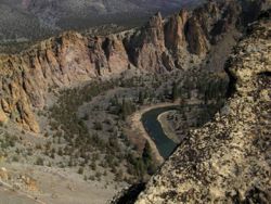
Misery Ridge Loop Hike
From Oregon Hikers Field Guide
- Start point: Smith Rock Trailhead
- End point: Monkey Face Viewpoint
- Trail Log: Trail Log
- Hike Type: Loop
- Distance: 3.8 miles
- Elevation gain: 1000 feet
- Difficulty: Moderate
- Seasons: Year round, except when snow or rain
- Family Friendly: Yes, for kids over 8
- Backpackable: No
- Crowded: Yes
|
|
Contents |
Hike Description
Smith Rock is an extremely popular area for rock climbers, but there are some beautiful trails as well. This area gets really hot in the summer and there's not a lot of shade. This hike is best early in the day, before the real heat sets in. There's many rattlesnakes here, especially near the river. Care should be taken, particularly in shady areas created by some of the hollow rocks.
From the Smith Rock Trailhead, take the main trail down to the Crooked River Bridge. A sign at the far end of the bridge marks the Misery Ridge Trail. Head straight up the switchbacks. The trail climbs continuously through switchbacks and oversize stairs. There are small cave-like areas eroded from the rock. You'll usually pass a few climbers in this first section. There's a flat spot for about 1/10 of a mile about half way up, but other than that it's steady climbing.
It's about 3/4 of a mile from the bridge to the Misery Ridge Summit. There's an open rock here with great views to the east and the south. The trail continues on a flat grade around to the other side of the ridge. There's a great viewpoint near the southwest corner of the rock and another at the northwest corner overlooking Monkey Face. Monkey Face is a huge, self standing pillar that gets its name from the distinctive shape of the top of the rock. Most of the major Oregon's Cascade peaks are visible from this viewpoint in the distance, including Mount Hood, Mount Jefferson, Three Sisters, Broken Top and Mount Bachelor.
The trail starts steeply down the west side of the ridge. About half way down the hill, there's a hollow rock that kids love to play in, although the area should be checked for snakes or creepy-crawlies first. The Misery Ridge Trail meets the Mesa Verde Trail at the base of Monkey Face. Climbers are common here. Head left on the Mesa Verde Trail. It slabs along the side of the hill, heading gradually downward. It's about a half mile farther down to the River Trail. Continue straight ahead on the River Trail. You'll stay close to the river for the rest of the hike. The trail runs southward to the bend in the river at the south end of the park. After you loop around the end of the rocks, you'll see lots of climbers on the various cliff faces. Follow the trail about another mile back to the Crooked River Bridge. Cross the bridge and head uphill to your car.
Regulations or restrictions, etc
- The park closes at 10PM
- There is a $5.00 daily fee
Maps
- Official Park Map
- Maps: Hike Finder
- Topo map with route
Trip Reports
- Search Trip Reports for Smith Rock
Related Discussions / Q&A
- Search Trail Q&A for Smith Rock
Contributors
- Stevefromdodge (creator)
- romann


