

Lost Lake Butte
From Oregon Hikers Field Guide


- Hikes to this location:
- Lost Lake Butte Hike (TH | <— —> | LOG)
- Weather forecast: NWS/NOAA
- Maps: Oregon Hikers Maps Google Maps
- Latitude, Longitude: 45.49575, -121.79588
- Elevation: 4468 feet
Description
Lost Lake Butte is an ancient shield volcano similar to Larch Mountain and Mount Defiance. From a distance, it shares a similar forested profile. It has been a popular hike for people in Lost Lake area for decades.
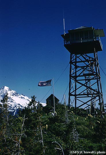
In about 1879, a large fire burned 2000-3000 acres in this area. In the early years of the 20th century, forest fires continued to present a menace to northwest forests. In the 1920s a series of fire lookouts was deployed throughout the area. Lost Lake Butte, with its commanding view, was a perfect place for a lookout. The original structure was a 40 foot tall wooden tower with a 49 square foot cab on the top. A cabin was provided nearby for the residence of the people working there. The original structure was replaced in 1949. The newer structure was destroyed in the 1962 Columbus Day Storm and was never rebuilt. The cabin burned sometime in 1970s. (firelookout.com)
Today, all the remains of the lookout is the foundation. South of there is a beautiful viewpoint marked by a jumble of huge boulders. Mount Hood commands the view to the south, across the broad valley of the West Fork Hood River. Hood River Mountain and Surveyor’s Ridge make up the eastern skyline.
More Links
- Picture of Lost Lake Butte Lookout
- FireLookout.com, a great site with pictures and information on PNW fire lookouts.
Contributors
- Stevefromdodge (creator)