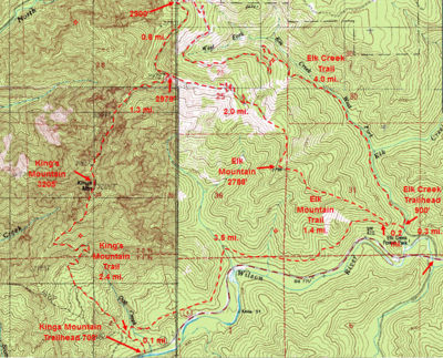
Kings Mountain Hike
From Oregon Hikers Field Guide
- Start point: Kings Mountain Trailhead
- End point: Kings Mountain
- Trail log: Trail Log
- Distance: 4.8 miles
- Elevation gain: 2545 feet
- High Point: 3226 feet
- Difficulty: Moderate
- Seasons: Possible all year; watch winter snow levels
- Family Friendly: No
- Backpackable: No
- Crowded: Yes
Contents |
Hike Description
The Kings Mountain Trail heads relentlessly upward, but it is not generally as steep as the nearby Elk Mountain Trail. During the winter it can be snowy, and after rain it can be muddy and slick. For most of this hike, you're under the forest canopy, recovering from the Tillamook Burn in the 1930s, and views only open up once you get near the summit. In the spring (late May to early June) Kings Mountain features an abundance of wildflowers including beargrass, paintbrush, penstemon, phlox, and the rare phantom orchid. If you want a very strenuous hike, the trail continues: see the Elk Mountain-Kings Mountain Loop Hike.
There is one trail out of the trailhead. After 0.1 miles in a ferny lush forest, reach the Wilson River-Kings Mountain Trail Junction. Take the Kings Mountain Trail straight ahead. The trail heads gradually up under alders and switchbacks at a view of a plunging creek. Then the path winds up steeply on a ridge before dropping and crossing the head of a small gully. After this, the trail rises gradually in a sword fern understory. Ascend a ridge with a rushing creek to the left and then walk on the level in Douglas-fir woods. There are big stumps in these woods: the area was heavily logged before the Tillamook Burn. The path rises gradually under alders, heads up an old road bed, and then switchbacks in an alder grove. Then the trail drops slightly on a road bed and passes a shortcut up to the left. Wind up, with a creek on the right, and reach the 2,000-foot level. The trail makes a level traverse and passes an old road bed shortcut dropping down steeply to the left. After this, the path makes a major switchback at the Kings Mountain-Kings Mountain Junior Trail Junction.
Continue on a level section past a 0.63 miles to the summit sign and then steeply up to where the gradient eases again. Look to the right for the old, now overgrown with conifers, logging road that begins the obscure Coxcomb route, a roundabout deep bushwhack/scramble to the summit. Keep up past the 2,500-foot level sign and wind up steeply, taking in some rock “steps.” A spur leads left 60 feet to a viewpoint of the west ridge. The trail keeps up steeply in Douglas-fir woods and passes a picnic table. Exit the woods and pass the 3,000-foot elevation sign to continue rising through small meadows. There’s a view of Mount Hood and Mount Adams through the trees before you reach the summit of Kings Mountain. Sign in at the summit register if you wish; the elevation, 3,226 feet, is posted. There is a great view overlooking the Lester Creek valley and points southwest down the Wilson River valley.
Fees, Regulations, etc.
- none
Maps
- Maps: Hike Finder
- Kings Mountain, Elk Mountain & Elk Creek Trails (Oregon Department of Forestry)
- Oregon Department of Forestry: Tillamook State Forest Map & Guide
Trip Reports
- Search Trip Reports for Kings Mountain
Related Discussions / Q&A
- Search Trail Q&A for Kings Mountain
Guidebooks that cover this hike
- 60 Hikes Within 60 Miles: Portland by Paul Gerald
- 25 Hikes on Oregon's Tillamook Coast by Adam Sawyer
- 100 Hikes: Oregon Coast by William L. Sullivan
- Oregon Hiking by Matt Wastradowski
- Pacific Northwest Hiking by Craig Hill & Matt Wastradowski
- Afoot & Afield: Portland/Vancouver by Douglas Lorain
- 75 Scrambles in Oregon by Barbara I. Bond
- 75 Hikes in Oregon's Coast Range and Siskiyous by Rhonda & George Ostertag
- Best Hikes Near Portland by Fred Barstad
- Take a Hike: Portland by Barbara I. Bond
- 100 Classic Hikes in Oregon by Douglas Lorain
- 50 Hikes in the Tillamook and Clatsop State Forests by the Sierra Club, Oregon Chapter
- 50 Hikes in the Tillamook State Forest by the Tillamook State Forest Committee, Columbia Group Sierra Club
- 50 Hiking Trails: Portland and Northwest Oregon by Don and Roberta Lowe
- 100 Oregon Hiking Trails by Don and Roberta Lowe
- Oregon Coast Camping & Hiking by Tom Stienstra & Sean Patrick Hill
- Oregon Hiking by Sean Patrick Hill
More Links
- Kings Mountain (Summit Post)
- Kings Mountain Hike - Tillamook State Forest (Share Oregon)
- Kings Mountain (Outdoor Project)
- Kings Mountain (Oregon Adventures)
- Kings Mountain Hike (Mazamas)
- Hike of the Week: Kings Mountain, OR (Backpacker)
- Kings Mountain Trail (All Trails)
- "Thigh pumper Kings Mountain trail in the Tillamook State Forest rewards with a view: Pacific Ocean to Mt. Hood" (Tillamook Coast, Oregon)
- Elk & Kings Mountain (Northwest Wildflowers)
Contributors
- User:retiredjerry (creator)


