

Hard Stone Trail Hike
From Oregon Hikers Field Guide

,_Pinnacles_Trail,_Cottonwood_Canyon_S.P..jpg)


- Start point: Hard Stone Trailhead

- End point: Mile 42 Bend
- Trail Log:
- Hike Type: In and out
- Distance: 5.2 miles
- Elevation gain: 110 feet
- High point: 605 feet
- Difficulty: Easy
- Seasons: All year
- Family Friendly: Yes
- Backpackable: No
- Crowded: No
|
|
Contents |
Hike Description
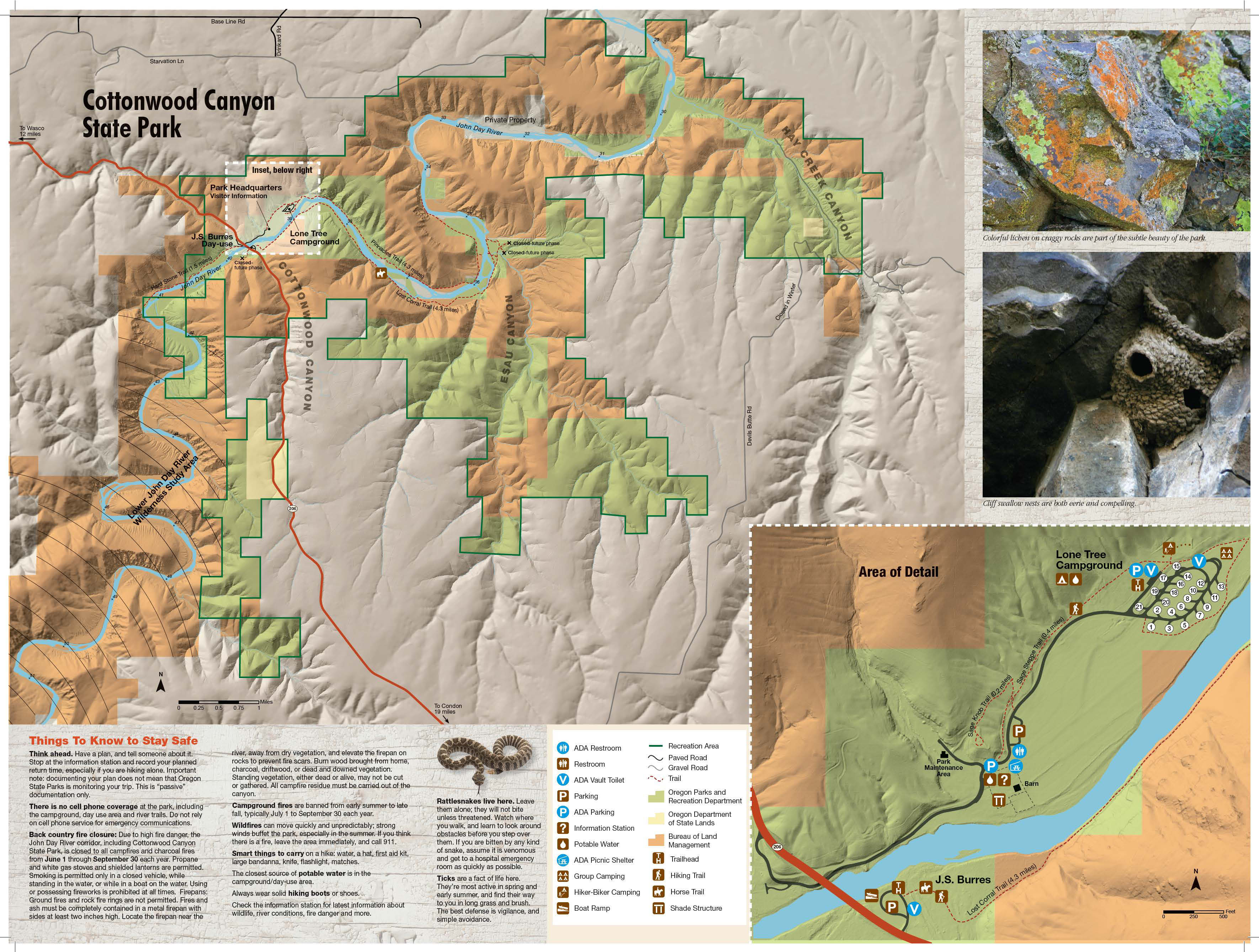
This flat hike in Oregon’s second-largest state park takes you up the John Day River to the Big Eddy, a whirlpool at a sharp bend, and then out along a sagebrush flat to view the layers of Columbia River Basalts at River Mile 42. Some remnants of settler farming practices remain: The barley fields reseed themselves, and you’ll pass low stone walls that may have been sheep folds. Note that rattlesnakes are quite common in the area, and any off-trail travel may involve picking up a few ticks, at least in early spring.
There’s a trail map at the parking area. Hike past this on an old farm road. To your left is a wide flat where barley continues to flourish. A sagebrush slope carpeted with bunchgrass and invasive cheatgrass rises to your right. Across the John Day River, you’ll see layers of basalt flows, with older Grande Ronde Basalts below and Wanapum Basalts (15 ½ million years old) above. Pass a short track that deviates a little above the farm road, and move closer to the river. Lizards scurry off at your approach, and California quail may be seen scuttling into the sage lands. At a grove of hackberry trees, you’ll see some stone enclosures that were probably a sheep fold. The trail undulates a little and passes a hunting area sign. A bench overlooks a quiet stretch of the river. Willows line the verge, and you’ll drop to a wide sagebrush flat backed by hackberry trees. Soon reach the cliffs at the sharp bend of the Big Eddy, a deep pool with a whirlpool which is most obvious at low water. The John Day River braids here around Hole Island, with most of the force running against the cliffs.
Pass below the sheer basalt layers of Wanapum Basalt, and note the junipers dotting Hole Island. Pairs of Canada geese take up residence here in the spring. Pass by a dismantled gate, and reach a small wooden barricade at a large juniper. Walk through the opening here, and head around the bend, from which you can observe the beautifully layered slopes above. Cliff swallows build their mud nests in the lichen-splashed basalt ramparts, and you may observe prairie falcons zipping low. The track reaches the river at the tip of Mile 42 Bend, and here you can stop to soak in the quiet before returning to your vehicle.
Maps
- Maps: Hike Finder
- Cottonwood Canyon State Park (Oregon State Parks)
- Bureau of Land Management, Fish & Wildlife Service, National Park Service, USDA Forest Service: Lower Deschutes & John Day Rivers
Regulations or restrictions, etc
- Information kiosk
- Dogs on leash
- Share trail with cyclists
Trip Reports
- Search Trip Reports for Hard Stone Trail Hike
- Cottonwood Canyon: Starvation Bend and Hard Stone Trail 5-15-18
- Cottonwood Canyon S.P. – Hard Stone Trail 5/6/17
Related Discussions / Q&A
- Search Trail Q&A for Hard Stone Trail Hike
Guidebooks that cover this hike
- none
More Links
- Cottonwood Canyon State Park (Oregon State Parks)
- Cottonwood Canyon State Park (Oregon State Parks)
- February camping and hiking at Cottonwood Canyon (2015) (Your Parks Go Guide)
- “Oregon’s new state park rough, magical (Statesman Journal)
- Cottonwood Canyon State Park (Oregon.gov)
- Cottonwood Canyon State Park Interpretive Prescription (Oregon.gov)
- Cottonwood Canyon State Park (Wikipedia)
Contributors
- bobcat (creator)