Difference between revisions of "Hamilton Creek Viewpoint"
From Oregon Hikers Field Guide
(Fixed caption) |
|||
| (14 intermediate revisions by 4 users not shown) | |||
| Line 3: | Line 3: | ||
[[Category:Viewpoints]] | [[Category:Viewpoints]] | ||
[[Category:Creeks]] | [[Category:Creeks]] | ||
| + | [[Category:Destinations]] | ||
| + | |||
[[Image:HamiltonCreekOverlook.jpg|thumb|400px|Hiker standing at the Hamilton Creek Viewpoint ''(Jeff Statt)'']] | [[Image:HamiltonCreekOverlook.jpg|thumb|400px|Hiker standing at the Hamilton Creek Viewpoint ''(Jeff Statt)'']] | ||
| − | [[Image: | + | [[Image:Looking down Hamilton Creek from the big slide.jpg|thumb|250px|Looking down Hamilton Creek from the big slide ''(bobcat)'']] |
| − | [[Image:HamiltonRailbed.jpg|thumb| | + | [[Image:HamiltonRailbed.jpg|thumb|250px|The old rail bed ''(Jeff Statt)'']] |
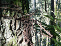
[[Image:TreeCable.jpg|thumb|250px|Cable left from turn-of-the-century forestry operations in the area ''(Jeff Statt)'']] | [[Image:TreeCable.jpg|thumb|250px|Cable left from turn-of-the-century forestry operations in the area ''(Jeff Statt)'']] | ||
| − | |||
| − | |||
| − | === | + | * Hikes including this location: |
| − | + | ** {{Hike ring|trailhead=Bonneville Trailhead|hike=Aldrich Butte-Cedar Falls Loop Hike|log=Aldrich Butte-Cedar Falls Loop Hike/Log|previous=Giant Forest-Hamilton Cutoff Trail Junction|next=Giant Forest Trail-Hamilton Railroad Grade Junction}} | |
| − | + | {{maplinkinfo|latitude=45.65721|longitude=-121.99237}} | |
| + | {{Elevation|405 feet}} | ||
| − | + | === Description === | |
| − | + | This is an unofficial name for a rather nondescript location above Hamilton Creek on the old Hamilton Railroad Grade. It's the location of a large slide, providing an excellent vantage point of the strong running Hamilton Creek down below. For a place so close to civilization, this is a very quiet spot. During the wet season, several long, ribbon-like cascades splash down the [[Hamilton Mountain]] side of the valley. Some of these seasonal falls rival [[Multnomah Falls]] in height! | |
| − | + | Hamilton Creek drains the entire watershed between [[Hamilton Mountain]] and [[Table Mountain]]. About a mile or so downstream from here, it empties out into the outlet stream for Greenleaf Slough and thence into the Columbia River. Hamilton Creek gets its start way up in the highlands near [[Three Corner Rock]]. | |
| − | + | ||
| − | + | It is said that the creek bed contains a myriad of treasures from by-gone days, treasures in the form of turn of the century railroads and forestry artifacts. If you were to ford the creek for a ways upstream, it would not be unusual to find all sorts of railroad ties, barrels, and other equipment left by workers in the late 1800s and early 1900s. In fact, there is a 'trail' to this location following an old rail bed from the west end of Greenleaf Slough. The trains used to carry newly cut trees out of the forests here. You may be surprised looking at your surroundings just how barren this whole area was just 100 years ago. | |
| + | |||
| + | Getting down to the creek from this spot is tricky but doable. Just remember you have to come back up! The easiest way down is probably at the north end of the slide. | ||
=== More Links === | === More Links === | ||
| + | |||
=== Contributors === | === Contributors === | ||
* [[User:jeffstatt|jeffstatt]] (creator) | * [[User:jeffstatt|jeffstatt]] (creator) | ||
Revision as of 02:31, 4 March 2017
- Hikes including this location:
- Weather forecast: NWS/NOAA
- Maps: Oregon Hikers Maps Google Maps
- Latitude, Longitude: 45.65721, -121.99237
- Elevation: 405 feet
Description
This is an unofficial name for a rather nondescript location above Hamilton Creek on the old Hamilton Railroad Grade. It's the location of a large slide, providing an excellent vantage point of the strong running Hamilton Creek down below. For a place so close to civilization, this is a very quiet spot. During the wet season, several long, ribbon-like cascades splash down the Hamilton Mountain side of the valley. Some of these seasonal falls rival Multnomah Falls in height!
Hamilton Creek drains the entire watershed between Hamilton Mountain and Table Mountain. About a mile or so downstream from here, it empties out into the outlet stream for Greenleaf Slough and thence into the Columbia River. Hamilton Creek gets its start way up in the highlands near Three Corner Rock.
It is said that the creek bed contains a myriad of treasures from by-gone days, treasures in the form of turn of the century railroads and forestry artifacts. If you were to ford the creek for a ways upstream, it would not be unusual to find all sorts of railroad ties, barrels, and other equipment left by workers in the late 1800s and early 1900s. In fact, there is a 'trail' to this location following an old rail bed from the west end of Greenleaf Slough. The trains used to carry newly cut trees out of the forests here. You may be surprised looking at your surroundings just how barren this whole area was just 100 years ago.
Getting down to the creek from this spot is tricky but doable. Just remember you have to come back up! The easiest way down is probably at the north end of the slide.
More Links
Contributors
- jeffstatt (creator)


