Difference between revisions of "Gorge-Munra Point Trail Junction"
From Oregon Hikers Field Guide
(added 2nd hike ring) |
(Add hike ring) |
||
| (21 intermediate revisions by 5 users not shown) | |||
| Line 1: | Line 1: | ||
[[Category:Columbia River Gorge]] | [[Category:Columbia River Gorge]] | ||
| + | [[Category:Northwest Oregon]] | ||
| + | [[Category:Trail Junctions]] | ||
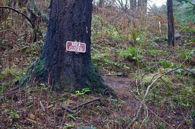
| − | [[Image: | + | [[Image:Junction with Munra Point Trail, Gorge 400 Trail.jpg|thumb|400px|The current closure sign at the beginning of the Munra Point Trail ''(bobcat)'']] |
| − | [[Image: | + | [[Image:MunraPointJct2.jpg|thumb|250px|This was the only sign that marked the start of the Munra Point Trail before it was closed to the public ''(Steve Hart)'']] |
| − | * Hikes | + | * Hikes including this destination: |
| − | ** {{Hike ring|trailhead=John B Yeon Trailhead|hike=Munra Point from Wahclella | + | ** {{Hike ring|trailhead=John B Yeon Trailhead|hike=Munra Point from Wahclella Hike|log=Munra Point from Wahclella Hike/Log|previous=HCRHT-Gorge Trail Junction at Tanner Creek|next=Munra Point}} |
| − | ** {{Hike ring|trailhead=John B Yeon Trailhead|hike=Munra Point from Yeon Trailhead Hike|log=Munra Point from Yeon Trailhead Hike/Log|previous= | + | ** {{Hike ring|trailhead=John B Yeon Trailhead|hike=Munra Point from Yeon Trailhead Hike|log=Munra Point from Yeon Trailhead Hike/Log|previous=Moffett Creek Bridge on Gorge Trail|next=Munra Point}} |
| − | {{ | + | ** {{Hike ring|trailhead=John B Yeon Trailhead|hike=McCord Creek to Tanner Creek Loop Hike|log=McCord Creek to Tanner Creek Loop Hike/Log|previous=Moffett Creek Bridge on Gorge Trail|next=Gorge-Historic Columbia River Highway Trail Tanner Creek West Junction}} |
| − | * | + | ** {{Hike ring|trailhead=Angels Rest Trailhead|hike=Columbia Gorge Traverse Hike|log=Columbia Gorge Traverse Hike/Log|previous=Moffett Creek Bridge on Gorge Trail|next=Gorge-Historic Columbia River Highway Trail Tanner Creek West Junction}} |
| − | = | + | {{maplinkinfo|latitude=45.62331|longitude=-121.97566}} |
| − | + | * Elevation: 145 feet | |
| − | + | ||
| − | + | ||
| − | + | ||
| − | + | ||
| − | == | + | === Description === |
| − | + | This is a trail junction near the freeway. Gorge Trail #400 continues its noisy route to the east and west. The unmaintained Munra Point Trail heads up the mountain to the south. Since the 2017 Eagle Creek Fire, the trail and the whole backcountry area around [[Munra Point]] have been closed to the public. | |
| − | |||
| − | == | + | === Contributors === |
| − | + | ||
| − | + | ||
* [[User:Stevefromdodge|Stevefromdodge]] (creator) | * [[User:Stevefromdodge|Stevefromdodge]] (creator) | ||
Latest revision as of 21:11, 22 September 2021
- Hikes including this destination:
- Munra Point from Wahclella Hike (TH | <— —> | LOG)
- Munra Point from Yeon Trailhead Hike (TH | <— —> | LOG)
- McCord Creek to Tanner Creek Loop Hike (TH | <— —> | LOG)
- Columbia Gorge Traverse Hike (TH | <— —> | LOG)
- Weather forecast: NWS/NOAA
- Maps: Oregon Hikers Maps Google Maps
- Latitude, Longitude: 45.62331, -121.97566
- Elevation: 145 feet
Description
This is a trail junction near the freeway. Gorge Trail #400 continues its noisy route to the east and west. The unmaintained Munra Point Trail heads up the mountain to the south. Since the 2017 Eagle Creek Fire, the trail and the whole backcountry area around Munra Point have been closed to the public.
Contributors
- Stevefromdodge (creator)


