Difference between revisions of "Elk Mountain Hike"
From Oregon Hikers Field Guide
m |
(change difficulty) |
||
| Line 3: | Line 3: | ||
[[Category:Tillamook State Forest]] | [[Category:Tillamook State Forest]] | ||
[[Category:All Season Hikes]] | [[Category:All Season Hikes]] | ||
| − | [[Category: | + | [[Category:Moderate Hikes]] |
[[Category:Wildflower Hikes]] | [[Category:Wildflower Hikes]] | ||
[[Category:Scrambles]] | [[Category:Scrambles]] | ||
| Line 20: | Line 20: | ||
{{Distance|3.2 miles}} round trip | {{Distance|3.2 miles}} round trip | ||
* High Point: 2788 feet | * High Point: 2788 feet | ||
| − | {{Elevation gain| | + | {{Elevation gain|2080 feet}} |
| − | {{Difficulty| | + | {{Difficulty|Moderate}} |
* Seasons: spring, summer, fall, possible in the winter | * Seasons: spring, summer, fall, possible in the winter | ||
* Family Friendly: No | * Family Friendly: No | ||
Revision as of 15:39, 5 February 2013
- Start point: Elk Creek Trailhead
- End point: Elk Mountain
- Trail log: Trail Log
- Distance: 3.2 miles round trip
- High Point: 2788 feet
- Elevation gain: 2080 feet
- Difficulty: Moderate
- Seasons: spring, summer, fall, possible in the winter
- Family Friendly: No
- Backpackable: No
- Crowded: Busy during summer and weekends, especially the first part to Burnt Lake
Contents |
Hike Description
Elk Mountain and King's Mountain are two popular hiking destinations in the Oregon Coast range. The trails are a little more rugged than typical Columbia Gorge or Mount Hood trails. They are lower elevation than Mount Hood hikes so they are possible in the winter when Mount Hood trails are snowed in.
There are two trailheads - Elk Mountain and King's Mountain, off highway 6 between Portland and Tillamook.
There are four hikes mentioned here - Elk Mountain Hike, King's Mountain Hike, Elk Mountain-King's Mountain Loop Hike, and Elk Creek Hike. These cover all the trail sections but you could obviously construct other combinations.
Carry water - there are (almost) no sources of water along the trails. This area is best for day hiking but the Elk Creek Hike mentions a possible backpack.
The Mazamas have adopted these trails, so they are well marked and well maintained.
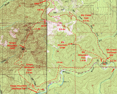
For the Elk Mountain hike, start just past the Elk Creek Campground. The road continues, over a bridge, to a parking area. There are two trails out of the trailhead - Take the Elk Mountain/Wilson River Trails up. There's a good sign. The other trail, the Elk Creek Trail follows the road past a closed gate.
After about 0.2 mile, there's the Wilson River-Elk Mountain Trail Junction. Take the Elk Mountain Trail up. The other trail, the Wilson River Trail continues straight and fairly level. Again, there's a good sign. From here, the trail is fairly rugged, as the picture attempts to show. You probably have to use your hands at a few places. The trail goes up and down a bit over small knolls. During the winter in can be snowy, and after rain it can be muddy making it almost impassable.
As you go along the trail, there are progressively better views down to the road, toward King's Mountain, and the rest of the Coast range. There is a sign and log box at the summit. There's a fairly large level area to soak in the views and rest.
When you're done looking around, go back the way you came. If you want a very strenuous hike, the trail continues, see Elk Mountain-King's Mountain Loop Hike.
Fees, Regulations, etc.
- none
Maps
- Click on area map below to enlarge
- Also see: Elk-Kings area map by Mazamas (PDF)
- Kings Mountain, Elk Mountain & Elk Creek Trails (Oregon Department of Forestry)
Trip Reports
- Search Trip Reports for Elk Mountain
Related Discussions / Q&A
- Search Trail Q&A for Elk Mountain
Guidebooks that cover this hike
- 60 Hikes Within 60 Miles: Portland, by Paul Gerald
- 100 Hikes/Travel Guide: Oregon Coast & Coast Range by William L. Sullivan
- Afoot & Afield: Portland/Vancouver by Douglas Lorain
- 75 Scrambles in Oregon by Barbara I. Bond
- 75 Hikes in Oregon's Coast Range and Siskiyous by Rhonda & George Ostertag
- Best Hikes Near Portland by Fred Barstad
- Take a Hike: Portland by Barbara I. Bond
- 50 Hikes in the Tillamook State Forest by the Tillamook State Forest Committee, Columbia Group Sierra Club
- 50 Hiking Trails: Portland and Northwest Oregon by Don and Roberta Lowe
- Oregon Hiking by Sean Patrick Hill
More Links
- See more information at Describe the link here
Contributors
- User:retiredjerry (creator)


