Elk Creek Hike
From Oregon Hikers Field Guide
- Start point: Elk Creek Trailhead
- End point:
- Trail log: Log
- Distance: 8.6 miles round trip
- Elevation gain: 2100'
- Difficulty: Difficult
- Seasons: spring, summer, fall, possible in the winter
- Family Friendly: Yes
- Backpackable: Maybe
- Crowded: Yes
Contents |
Hike Description
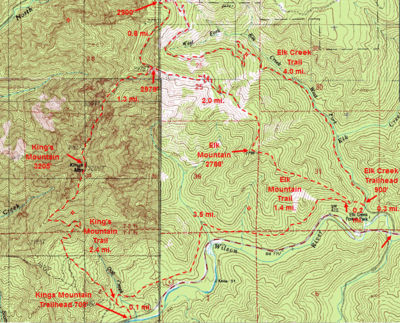
Elk Mountain and King's Mountain are two popular hiking destinations in the Oregon Coast range. The trails are a little more rugged than typical Columbia Gorge or Mount Hood trails. They are lower elevation than Mount Hood hikes so they are possible in the winter when Mount Hood trails are snowed in.
There are two trailheads - Elk Mountain and King's Mountain, off highway 6 between Portland and Tillamook.
There are four hikes mentioned here - Elk Mountain Hike, King's Mountain Hike, Elk Mountain-King's Mountain Loop Hike, and Elk Creek Hike. These cover all the trail sections but you could obviously construct other combinations.
Carry water - there are (almost) no sources of water along the trails. This area is best for day hiking but the Elk Creek Hike mentions a possible backpack.
The Mazamas have adopted these trails, so they are well marked and well maintained.
The Elk Creek Trail is an easy trail, it follows an old logging road. There's a gate that prevents any vehicles. The only thing that makes the trail difficult is the length and elevation gain. The logging road and route have existed for a long time, but only recently has it been officially named the Elk Creek Trail. Most trail guides don't mention it.
In November 2006 there were some significant washouts that make this trail much more difficult in the first mile. There is one place in particular, where you have to scramble up the bank and walk around. It's marked with red flagging. Many people have successfully negotiated this but some people may find it too difficult.
Start just past the Elk Creek Campground. The road continues, over a bridge, to a parking area. There are two trails out of the trailhead - Take the the Elk Creek Trail which follows the road past a closed gate. There's a good sign. The other trail, the Elk Mountain/Wilson River Trail goes up.
The first part of the trail follows Elk Creek with a gradual elevation gain. Then the trail starts getting steep with a few switchbacks. After 4 miles, take a left turn. The logging road you were following, continues, eventually to a road. If you followed this, there would probably be few people and some nice views. There is sign at this turn. The trail you want to follow is another logging road, but it starts steeply, so it's easy to miss. This junction is the end of the official Elk Creek Trail and the beginning of the official Elk Mountain Trail.
It's another 0.8 miles to the 3 way junction to Elk Mountain and King's Mountain. This is the end of this hike. Go back the way you came. If you decide to go back via the Elk Mountain Trail, beware, that trail is very difficult, especially near Elk Mountain. It would be better to go the other direction, so that if it gets too difficult it would be easier to turn around.
The trails in the Elk Mountain/King's Mountain are mainly day hikes, but if you're looking for a backpack, for example in the winter when there isn't much else that's snow free, there are some flat areas to camp, at the 3 way junction or towards Elk Mountain. There is probably drinking water (in the winter) on the last 0.8 miles of the Elk Creek Hike. Beware that there are periods in the winter when there is too much snow here.
Fees, Regulations, etc.
- Northwest Forest Pass required
Trip Reports
(Click here to add your own)
Related Discussions / Q&A
(Click here to ask a question or start a conversation)
Guidebooks that cover this hike
- 60 Hikes within 60 Miles of Portland, by Paul Gerald
More Links
- See more information at Describe the link here
Contributors
- User:retiredjerry (creator)


