Eagle Creek to Punch Bowl Falls Hike
From Oregon Hikers Field Guide
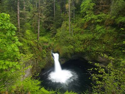
File:EagleCreekTrail02.jpg
Greenery abounds along the Eagle Creek trail
Contents |
Info
- Start point: Eagle Creek Trailhead
- End point: Punchbowl Falls
- Distance: 4 miles (round trip)
- Elevation Gain: 400 feet
- Difficulty: Easy to moderate
- Seasons: Year round
- Backpackable: No
- (but there are backpacking options further up trail)
- Crowded: Yes
- Family Friendly: Yes (children 10 and up)
- (Due to the relatively short distance and moderate elevation gain, this might seem a nice choice for children , but parents are cautioned that the trail overlooks cliffs in two sections early on, with only a guard wire for support)
Hike Description
Eagle Creek is the quintessential hike in the Columbia River Gorge, boasting dozens of spectacular waterfalls, tall basalt cliffs, ubiquitous talus slopes, and the lush temperate rain forests that so characterize the Pacific Northwest. It is considered by many to be the most resplendent hiking destinations in the Northewest -- no doubt, essential fare for Portland-area outdoor lovers.
The Eagle Creek to Punchbowl Falls hike, is one of the shorter options for enjoying the
Maps
- See clickable image to the right
- Hike Finder
- Topozone
Trip Reports
- Eagle Creek to Tunnel Falls 9/23/06 - 9/24/06
- Eagle Creek to Wahtum Lake, and Chinidere Mt 7/12/06 - 7/14/06
(Click here to add your own)
Related Discussions / Q&A
- (Click here to ask a question or start a conversation)
Guidebooks that cover this hike
- 100 Hikes in Northwest Washington - 2nd Edition, by William Sullivan
More Links
- See more information at Splintercat.org


