Douglas Trail to Wildcat Mountain Hike
From Oregon Hikers Field Guide
- Start point: Douglas Trailhead
- End Point: Wildcat Mountain
- Trail Log: Trail Log
- Hike Type: Out and back
- Distance: 5.0 miles round-trip
- Elevation gain: 1100 feet (800 feet to McIntyre Ridge viewpoint)
- High Point: 4,480 feet (4,146 feet at McIntyre Ridge viewpoint)
- Difficulty: Easy
- Seasons:Late Spring through Fall
- Family Friendly: Yes
- Backpackable: Yes—connects to trails in the Salmon-Huckleberry Wilderness
- Crowded: No
Contents |
Description
The Douglas Trail provides the shortest, fastest route into the western edge of the Salmon-Huckleberry Wilderness, with nice views into the Eagle Creek Canyon, and ridgetop meadows and rock gardens within a short hike of the recently relocated Douglas Trailhead. Be sure to read the trailhead description, however, since this pretty hike begins on a logging spur and can be tricky to find for first-timers.
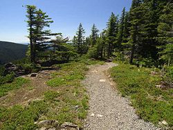
From the new Douglas Trailhead, hike past the trail sign along a new 0.5 mile section of trail (built by volunteers in 2014) that soon traverses above the old Wildcat Quarry. Soon, the trail emerges on open cliff top, with fine views into the Eagle Creek Canyon, below, and Wildcat Mountain, above.
From here, the trail rambles at a moderate grade through handsome, often open forests, with rhododendron and beargrass blooms along the trail in early summer. You will pass a couple unmarked side trails along the way, but keep right to stay on the main trail. Soon, you will reach the junction with the McIntyre Ridge Trail at 1.9 miles. The meadows at the crest of McIntyre Ridge make for a nice destination on this hike that is worth visiting on your return trip (described below). For now, continue on the Douglas Trail for 0.6 miles to the short 400 ft. spur to the top of Wildcat Mountain. The spur is not marked, so watch for it at the crest of the Douglas Trail—if you're going downhill, you have missed the summit trail.
The view from the top of Wildcat Mountain once extended in all directions, when a 1930s Forest Service lookout stood here. But trees are rapidly obscuring views to the north, including Mount Hood. Still, the views to the south and west, into the Eagle Creek drainage and points beyond, is well worth the trip. Plus, you're likely to have the summit to yourself, if you're looking for solitude.
For more scenery, you have a couple of options: if you simply continue eastward on the Douglas Trail, the rock gardens at a craggy ridge top 0.8 miles beyond Wildcat Mountain make for a nice destination that features Mount Hood views, and another look down into the Eagle Creek Canyon. Extending your hike to this spot would increase the round trip distance to 6.6 miles. You can also head back to the McIntyre Ridge Trail junction, turn right and follow this path 0.7 miles north to a stunning viewpoint complete with a wood bench where you can relax and enjoy views west into the Willamette Valley, and east, across Boulder Creek canyon, to Mount Hood. This option would increase the round trip distance to 6.4 miles. Neither option adds significant elevation gain.
To complete your hike, retrace your steps back to the Douglas Trailhead.
Target shooters are abundant along the roads around here. Use caution when hiking and driving in this area.
Maps
Trip Reports
- Search Trip Reports for Wildcat Mountain
Related Discussions / Q&A
- Search Trail Q&A for Wildcat Mountain
Guidebooks that cover this destination
More Links
Page Contributors
- Splintercat (Tom Kloster) (primary)


