Difference between revisions of "Cooper Spur Hike"
From Oregon Hikers Field Guide
(Remove Covid warning) |
(Updates) |
||
| Line 45: | Line 45: | ||
After pausing to enjoy the [[Cooper Spur Shelter|shelter]], return to the main trail and continue the remaining 0.8 mile climb toward the looming crest of [[Cooper Spur]]. Though the trail quickly gains elevation, the grade is always good as the route climbs high into the stark tundra zone of the mountain. Soon the trail begins a series of broad switchbacks on the increasingly steep shoulder of the spur, passing stunning viewpoints of the awesome north face of [[Mount Hood]] and the rugged icefalls of the Eliot Glacier. | After pausing to enjoy the [[Cooper Spur Shelter|shelter]], return to the main trail and continue the remaining 0.8 mile climb toward the looming crest of [[Cooper Spur]]. Though the trail quickly gains elevation, the grade is always good as the route climbs high into the stark tundra zone of the mountain. Soon the trail begins a series of broad switchbacks on the increasingly steep shoulder of the spur, passing stunning viewpoints of the awesome north face of [[Mount Hood]] and the rugged icefalls of the Eliot Glacier. | ||
| − | As you near the crest, a final set of switchbacks bring you to views south of the Newton Clark Glacier before suddenly reaching several stone climber's windbreaks at the top of the spur. From here, the view extends from [[Mount Jefferson]] to [[Mount Rainier]], and includes a good portion of the Columbia Plateau to the east. Look for an inscription from an early 1900s Japanese climbing party on a boulder near the trail. This makes a good stopping point to relax and admire the view. Many hikers choose to explore the ridge as far as Tie-in Rock, an obvious massive boulder right on the crest where climbers traditionally rope up. Beyond Tie-in Rock, the | + | As you near the crest, a final set of switchbacks bring you to views south of the Newton Clark Glacier before suddenly reaching several stone climber's windbreaks at the top of the spur. From here, the view extends from [[Mount Jefferson]] to [[Mount Rainier]], and includes a good portion of the Columbia Plateau to the east. Look for an inscription from an early 1900s Japanese climbing party on a boulder near the trail. This makes a good stopping point to relax and admire the view. Many hikers choose to explore the ridge as far as Tie-in Rock, an obvious massive boulder right on the crest where climbers would traditionally rope up. Beyond Tie-in Rock, walking the ridge forward to another high point offers closeup views over the Newton Clark Glacier. Beyond this high point, dangerous rockfall is common in the summer and fall. |
Retrace your route for the 3 1/2 mile return to the trailhead. | Retrace your route for the 3 1/2 mile return to the trailhead. | ||
Revision as of 02:39, 26 August 2021
- Start point: Cloud Cap Trailhead
- Ending Point: Cooper Spur
- Trail Log: Trail Log
- Hike Type: Out and Back
- Distance: 7.1 miles round-trip
- Elevation gain: 2680 feet
- High point: 8,510 feet
- Difficulty: Moderate
- Seasons: July - November
- Family Friendly: No
- Backpackable: No
- Crowded: On summer weekends
Contents |
Hike Description
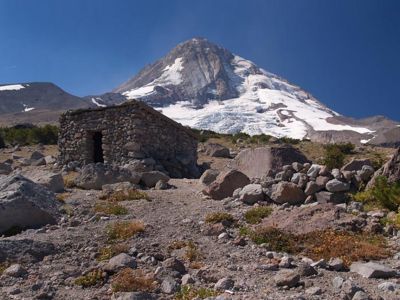
This spectacular hike begins at the Cloud Cap Trailhead and quickly climbs to several soaring viewpoints above the spectacular Eliot Glacier en route to the rocky crest of Cooper Spur, the highest point on the mountain that can be reached by trail. The route also passes one of the surviving rustic stone shelters that once dotted the Timberline Trail. Historic Cloud Cap Inn is closed to the public, but the grounds of inn are worth a stop before or after your hike. Cloud Cap Trailhead gets very crowded on summer weekends, so try this one on a weekday, if possible.
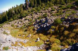
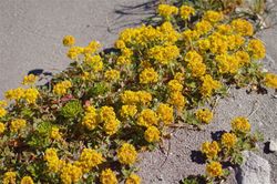
From the trailhead, walk through the picnic area/campground to a junction on the Timberline Trail. Head left and uphill for a short distance to another junction, where a spur trail to the Eliot Glacier Moraine heads off to the right. Stay left on the Timberline Trail, following the sign pointing to Gnarl Ridge. Pass through a handsome old growth forest of huge mountain hemlock as you climb into the upper reaches of Tilly Jane Canyon. While the route is well-graded, it also travels across soft volcanic ash for the first mile. But as you round a bend into Tilly Jane Canyon, and views of Mount Hood loom ahead, you’ll forget the soft sand below your feet. In this section, the trail switchbacks up Tilly Jane Canyon amid boulders and scattered alpine wildflowers. If you’re hiking early in the season, expect lingering snow and watch for distinctive cairns with wooden posts to guide your way.
Next, the trail enters a windswept forest of mountain hemlock and whitebark pine and then exits near a junction with the Tilly Jane Trail. Turn right (uphill) here, following the sign to Cooper Spur. The spur is the hulking, rocky ridge straight ahead, but after 100 yards on this trail, watch on the right for the Cooper Spur Shelter at the 1.2 mile mark. Walk to the shelter on one of many informal paths, and take a moment to appreciate the architecture and construction. This rustic stone building has existed on the site for more than seventy years, somehow surviving the avalanches that have gradually destroyed most of the other shelters along the Timberline Trail.
The shelter has an open door, a roof that drips when it rains, and a fireplace with chimney. There isn't room for more than a couple people, but it could be very useful in a storm. There are also a number of places to pitch a tent nearby. The closest drinking water is down the trail in the Tilly Jane Canyon.
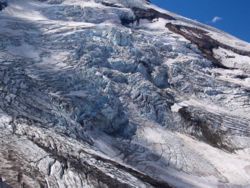
After pausing to enjoy the shelter, return to the main trail and continue the remaining 0.8 mile climb toward the looming crest of Cooper Spur. Though the trail quickly gains elevation, the grade is always good as the route climbs high into the stark tundra zone of the mountain. Soon the trail begins a series of broad switchbacks on the increasingly steep shoulder of the spur, passing stunning viewpoints of the awesome north face of Mount Hood and the rugged icefalls of the Eliot Glacier.
As you near the crest, a final set of switchbacks bring you to views south of the Newton Clark Glacier before suddenly reaching several stone climber's windbreaks at the top of the spur. From here, the view extends from Mount Jefferson to Mount Rainier, and includes a good portion of the Columbia Plateau to the east. Look for an inscription from an early 1900s Japanese climbing party on a boulder near the trail. This makes a good stopping point to relax and admire the view. Many hikers choose to explore the ridge as far as Tie-in Rock, an obvious massive boulder right on the crest where climbers would traditionally rope up. Beyond Tie-in Rock, walking the ridge forward to another high point offers closeup views over the Newton Clark Glacier. Beyond this high point, dangerous rockfall is common in the summer and fall.
Retrace your route for the 3 1/2 mile return to the trailhead.
Maps
- Maps: Hike Finder
- Green Trails Maps: Mt Hood, OR #462
- Geo-Graphics: Mount Hood Wilderness Map
- Adventure Maps: Mt. Hood Area
- U.S. Department of Agriculture, Forest Service: Mt. Hood National Forest
- Discover Your Northwest: Mt. Hood National Forest North: Trail Map & Hiking Guide
- U.S. Department of Agriculture, Forest Service: Hood River Ranger District
- National Geographic Trails Illustrated Map: Mount Hood Wilderness
- National Geographic Trails Illustrated Map: Mount Hood
Fees, Facilities, etc.
- Northwest Forest Pass (or America the Beautiful Pass) required at Cloud Cap Trailhead
- Vault toilets, campground, and picnic tables
Trip Reports
- Search Trip Reports for Cooper Spur
Related Discussions / Q&A
- Search Trail Q&A for Cooper Spur
Guidebooks that cover this destination
- Hiking Oregon's Geology by Ellen Morris Bishop
- Day Hiking Mount Hood: A Year-Round Guide by Eli Boschetto
- 60 Hikes Within 60 Miles: Portland by Paul Gerald
- PDX Hiking 365 by Matt Reeder
- Day Hikes in the Pacific Northwest by Don J. Scarmuzzi
- Oregon's Best Wildflower Hikes: Northwest Region by George Wuerthner
- 100 Hikes in Northwest Oregon & Southwest Washington by William L. Sullivan
- Trips & Trails: Oregon by William L. Sullivan
- Portland Hikes by Art Bernstein & Andrew Jackman
- Day Hike! Columbia Gorge by Seabury Blair, Jr.
- Hiking Oregon by Donna Lynn Ikenberry
- Hiking Oregon by Lizann Dunegan
- Hike America: Oregon by Lizann Dunegan
- 50 Hikes in Oregon by David L. Anderson
- Hiking Oregon's Mount Hood & Badger Creek Wilderness by Fred Barstad
- Oregon Nature Weekends by Jim Yuskavitch
- 70 Hiking Trails: Northern Oregon Cascades by Don & Roberta Lowe
- 62 Hiking Trails: Northern Oregon Cascades by Don & Roberta Lowe
- 105 Virtual Hikes of the Mt. Hood National Forest by Northwest Hiker
- Snowshoe Routes - Oregon by Shea Anderson
- Oregon Hiking by Sean Patrick Hill
- Oregon's Columbia River Gorge: Camping & Hiking by Tom Stienstra & Sean Patrick Hill
- Pacific Northwest Hiking by Scott Leonard & Sean Patrick Hill
- Canine Oregon by Lizann Dunegan
More Links
- Cooper Spur Trail #600B (USFS)
- Cooper Spur Trail (USFS)
- Cooper Spur Hike (Northwest Hiker)
- Cloud Cap to Tie-In Rock (Cooper Spur) (Scott Dawson)
- Cooper Spur (Linda's Lens)
- Cooper Spur: Highest Trail on Mt. Hood (Anne's Travels)
- Cooper Spur + Cloud Cap Hike (Hiking Project)
- Hike Cooper Spur (The Outbound Collective)
- Cooper Spur (On Mount Hood)
- "Mount Hood's Cooper Spur hike has views of Eliot Glacier" (Oregon Live)
- Cooper Spur (Summit Post)
Page Contributors
- Splintercat (Tom Kloster) (primary)


