Broken Top East Cirque Hike
From Oregon Hikers Field Guide
- Start point: Broken Top Trailhead
- End Point: Bend Glacier Viewpoint
- Trail Log:
- Hike Type: In and out
- Distance: 5.8 miles
- Elevation gain: 1385 feet
- High Point: 8,250 feet
- Difficulty: Moderate
- Seasons: Mid-summer into fall
- Family Friendly: Yes, for older kids
- Backpackable: Yes
- Crowded: Yes
Contents |
Description
Broken Top is a 300,000 year-old highly eroded stratovolcano, severely modified in its aspect during the last glacial age. It is part of a province of some 50 lava-spewing vents in the Three Sisters area. This short hike offers close views of Broken Top’s colorful ramparts and a panorama of alpine scenery to admire. Save a sunny day for this excursion so you can appreciate the closeup views of the old volcano, the turquoise waters of No Name Lake, the remains of the Bend Glacier, and a stunning view of the Three Sisters and north up the Cascades. The hike begins in mountain hemlock parklands, but soon enters a more open landscape of subalpine fir and whitebark pine, passing meltwater streams and alpine meadows with the prominences of Ball Butte and Broken Hand looming above.
Although this is a short hike, offering much scenic pleasure for the miles, the biggest challenge is the drive to the trailhead. Conditions on the 5 ¼ miles of unpaved access roads vary from year to year, but high clearance is always advised. If you’re in any doubt about the worthiness of your vehicle, begin the hike at Todd Lake and plan for a 14-mile round-trip excursion. Note also that the hike is extremely popular, and despite the road conditions, you’ll find many other Subarus, Landrovers, Honda CR-Vs, and Ford Explorers at the trailhead.
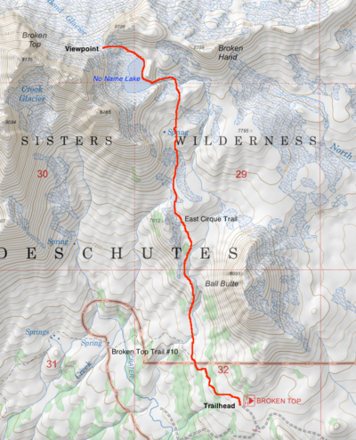
At the trailhead, sign in at the wilderness permit box, and begin hiking up the Broken Top Trail #10. Enter a mountain hemlock/subalpine fir parkland with the reddish prominence of Ball Butte looming above. You’ll soon get a view into Broken Top’s cavernous south cirque, which is still being actively excavated by the Crook Glacier. Look south for a view of Mount Bachelor. Bear left at a trail restoration sign, and make a descending traverse past some large mountain hemlocks to enter the Three Sisters Wilderness. Reach a trail junction at a post, and keep right on an unofficial but always obvious tread.
Head up a sandy open slope vegetated with fleeceflower and sedges to cross a creek with Ball Butte rearing to your right. Get more views into the south cirque as you hike up pumice slopes and cross a rubble field. Ascend a steeper gravel slope, and get views of a couple of small waterfalls in the creek. Heather and grouseberry form small mats. Looking back, the view extends to Sparks Lake and Mount Bachelor. At the top of a rise, you’ll see ahead the moraines that dam No Name Lake and can admire the colorful banded layers in Broken Top’s eroded ramparts. Round a corner to get a view of Broken Hand dominating the ridge ahead. Cross alpine meadows, and continue walking below the eastern parapets of Broken Top. The creek, which issues from No Name Lake, runs through a wide alpine bowl to your right. Pass through scattered copses of whitebark pines, and cross a small brook. There’s one more stunning view back to Mount Bachelor before you descend to a rubble-filled debris bowl below tall moraines.
Cross the creek, and then keep left to follow the creek up to a breach in the moraines. This notch was the site of a major breach in October 1966. It is surmised that a calving iceberg from the Bend Glacier displaced water in the lake, which breached the moraines here. The accumulating debris poured down the alpine meadows, intersected with the Crater Creek Ditch, and then joined the Soda Creek drainage to bury a section of the Cascade Lakes Highway and fan out as a debris delta on the northern shore of Sparks Lake.
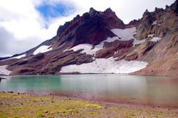
Once, you’ve clambered through the notch, a memorable vista is spread before you. Broken Top’s crags loom above the turquoise waters of No Name Lake, which is fed by melt from the eastern remnant of the Bend Glacier, which once draped both the northern and eastern slopes of the mountain. In 2017, a herd of 19 elk crossing high above the opposite shore of the lake was swept downslope and remained concealed by snow until the following year. Some of the carcasses ended up in the lake, while the remains of the others might be seen with binoculars on the lowest snow field.
Follow the path along the east shore of No Name Lake, and then ascend a fell field where paintbrush, arnica, buckwheat, and partridge-foot bloom in the short flowering season. A solitary dipper may be prospecting the lakeshore, and look out also for water pipits and bluebirds. You’ll reach the ridge crest to enjoy expansive views across Park and Red Meadows to the Three Sisters, with Mount Washington and Mount Jefferson distinguishable to the north. Much of the forest in view was scorched by the Pole Creek Fire of 2012. Below is the more substantial fragment of the Bend Glacier, with a couple of meltwater tarns glistening in the sun.
Fees, Regulations, etc.
- High clearance necessary for the drive to the trailhead
- Self-issued wilderness permit
- Restrooms, information kiosk
- Dogs on leash at all times
Maps
- Maps: Hike Finder
- Green Trails Maps: Three Sisters #621
- Green Trails Maps: Bend – Three Sisters #622SX
- Geo-Graphics: Three Sisters Wilderness Map
- U.S. Department of Agriculture, Forest Service: Bend-Fort Rock Ranger District
- U.S. Department of Agriculture, Forest Service: Deschutes National Forest
- Pacific Northwest Recreation Map Series: Willamette Cascades
- Adventure Maps: Three Sisters Wilderness Trail Map
- National Geographic Trails Illustrated Map: Bend – Three Sisters
Trip Reports
- Search Trip Reports for Broken Top East Cirque Hike
- Broken Top’s East Cirque Lake 9-13-18
- Broken Top & Unnamed Lake
- Broken Top – September 1st, 2014
- Broken Top’s Hidden Lake (AKA No Name Lake) – 2013/08/28
Related Discussions / Q&A
- Search Trail Q&A for Broken Top East Cirque Hike
- Broken Top trail head from NF310/380
- Broken Top from Broken Top trail head
Guidebooks that cover this destination
- Day Hiking: Bend and Central Oregon by Brittany Manwill
- 100 Hikes in the Central Oregon Cascades by William L. Sullivan
- Bend, Overall by Scott Cook
- Hiking Oregon’s Central Cascades by Bruce Grubbs
- Hiking Oregon’s Three Sisters Country by Bruce Grubbs
- Hiking Central Oregon & Beyond by Virginia Meissner
- Trail Running: Bend and Central Oregon by Lucas Alberg
More Links
- Broken Top Trail (USFS)
- Broken Top Trailhead (USFS)
- Broken Top to No Name Lake (Hike Oregon)
- Hike the Broken Top Trail for beautiful views (Hike Central Oregon)
- Hike to Broken Top Crater and No Name Lake (Calipidder)
- “No Name Lake is a gem of the Central Oregon Cascades” (Bend Bulletin)
- That Jaw-Dropping Hidden Lake in Oregon Has No Name (That Oregon Life)
- Broken Top Crater Hike (Outdoor Project)
- Broken Top Crater: A Lake With a View (Visit Central Oregon)
- Field Geology of S.W. Broken Top Quadrangle, Oregon (Oregon Department of Geology and Mineral Industries)
- “An Oregon mystery: The dead elk of No Name Lake” (KVAL)
- “Elk herd killed by avalanche emerges from snow” (Bend Bulletin)
Page Contributors
- bobcat (creator)


