After two weeks of non-stop business travel - oh the joys of airports, airport food (really?), and stuffy hotel rooms - I needed a day off and a hike to prevent the onset of severe hiking deficiency syndrome (SHDS). Something long with a view. So Larch Mtn, but going up via The Elevator Shaft to make a loop, seemed about right. I got going from Multnomah Falls early enough to be the only one there.
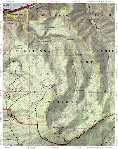
Then it was along Tr 400 and up the Elevator Shaft - where the use trail has gotten still more obvious. There's a lot of poison oak sprouting out where the trail goes through sections of brush and trees.
From the top of the Shaft, I followed the good use trail over to the Oregon Trail Club's Lodge and then another use trail from there up to the Franklin Ridge Trail (427) at about 2100' and followed that trail to its junction with the Oneonta Trail (424). Tr 424 took me all the way to the Larch Mtn Road (NF 15). Except for large blowdowns in a few places, these trails were free of snow and in good condition.
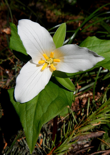
Trillum were blooming at select spots on the forest floor.
Above 3600', however, Tr 424 was covered with snow, as was the Larch Mtn Rd,
the parking lot,
and the fee station.
The day had started out slightly overcast but by the time I reached Sherrard Point, full bluebird weather conditions prevailed and the view was as big as expected. Hood,
Adams,
and all the rest, from Rainier to Jefferson, were in view. Despite all the snow in the parking lot, there was no snow on the paved steps leading to the summit or on the summit. I had the summit to myself until just before I was ready to leave, when one other person showed up. I went down via the Larch Mtn Tr (441), which had only a few patches of snow on it above 3700' and none below. This descent involved crossing the Bridge of Impending Collapse, where a small sign suggests crossing it one person at a time.
After that it was down to the paved "trail" and then some dodging and weaving through the tourists (not too many) back to my car. Someone wanted my parking space so bad they were willing to wait, idling, through my whole post-hike, boot removal, clean T-shirt routine just to claim it. Still, a perfect day for a hike! 16.0 mi, 4300' EG.
The Elevator to Larch 16-May-2012
Re: The Elevator to Larch 16-May-2012
I was up there Saturday and did almost the exact same route as you...the snow level at the Larch pay station in your photo looks at least 10-12" lower. Thanks for posting and pictures! Great hike!
- Don Nelsen
- Posts: 4383
- Joined: May 28th, 2008, 10:03 pm
- Location: Vancouver, WA
Re: The Elevator to Larch 16-May-2012
Bruce: "Bridge of impending collapse" LOL!
Thanks for the report and snow update, good job - looks like the higher elevations are melting out nicely which is very good to see. Here's a comparison shot of the sign in the parking lot taken June 20th, 2008 - what a contrast!
dn
Thanks for the report and snow update, good job - looks like the higher elevations are melting out nicely which is very good to see. Here's a comparison shot of the sign in the parking lot taken June 20th, 2008 - what a contrast!
dn
"Everything works in the planning stage" - Kelly
"If you don't do it this year, you will be one year older when you do" - Warren Miller
Re: The Elevator to Larch 16-May-2012
Whoh. I've seen it before, but for some reason that shot of the elevator shaft looks quite intimidating. not for the faint of heart. That was quite a nice day of hiking you did! I hope you found some relief from SHDS. What a horrid condition to suffer with.
Re: The Elevator to Larch 16-May-2012
Fortunately, SDHS is a chronic condition that requires treatment at least once a week and preferably more often during the summer.Crusak wrote:Whoh. I've seen it before, but for some reason that shot of the elevator shaft looks quite intimidating. not for the faint of heart. That was quite a nice day of hiking you did! I hope you found some relief from SHDS. What a horrid condition to suffer with.
Don't be put off by my shot of the Elevator Shaft - it's not really that steep and the use trail is a good, reasonably wide tread. Biggest threat is probably the poison oak.
Re: The Elevator to Larch 16-May-2012
Great report Van, I've been thinking about the Elevator shaft recently, haven't gone up it in a while it's about time I went that way again!
Re: The Elevator to Larch 16-May-2012
Did you post hole through the snow? He much of a hassle was that? I was thinking of doing this exact route Friday so a very timely report!
Re: The Elevator to Larch 16-May-2012
Is the "elevator shaft" a real trail (or looks like a trail) or just some sort of a shortcut you have to know to get up to the trail?
-
- Posts: 171
- Joined: May 25th, 2010, 6:17 pm
Re: The Elevator to Larch 16-May-2012
I made the loop from the Falls parking lot up Multnomah creek, and down Franklin Ridge yesterday, Thursday (5/17). Only a little hard snow on the north side, and a few hundred yards on the road. No post holing. Go soon, before the road opens. Franklin Ridge is a very pleasant way down, and you get the bonus of the outstanding Trails Club viewpoint at the north end of the ridge. From the Trails Club lodge, you can either follow the use path to the elevator shaft, or the old road and trail to the high water portion of the Multnomah trail.
Re: The Elevator to Larch 16-May-2012
Is the Elevator Shaft a real trail, no I wouldn't call it a real trail. Its a rockslide with some switchbacks (over a hundred according to the trip guide here). It is a pretty nice climb up to the top but you do need to watch the bands of Poison Oak.
Once your on top though its a very pretty walk over to the Lodge.
Franklin Ridge is an awesome ridge because its a Hemlock forest and has a different flavor to it from your typical Doug Fir.
Once your on top though its a very pretty walk over to the Lodge.
Franklin Ridge is an awesome ridge because its a Hemlock forest and has a different flavor to it from your typical Doug Fir.