Last December, in search of a new or different hike, I wandered up Augspurger via its SE ridge, starting from the road below and E of the radio facility. After I posted the TR, Born2BBrad was good enough to hint at a way to climb up to the radio facility directly from Hwy 14. Having hiked Augsperger from the Dog Mtn TH last July, I got the idea of making a complete loop from the Dog Mtn TH, up the SE ridge, and back to the TH on the official Augspurger Trail (#4407). Since today's weather forecast had the heavy stuff arriving late in the evening, I figured I had time to do this loop before the weather closed in (
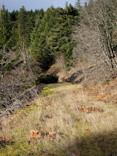
oh, what fools these mortals be...). It was windy but clear when I left the Dog Mtn TH early (not looney early, but early) and headed E along Hwy 14. Going in this direction got the boring stuff (walking along 14) out of the way when traffic was light and meant that I'd arrive right back at the car after the hike. On the 100K maps, a dirt road is shown leaving the Cook-Underhill Rd and climbing up to the radio facility at 2400' (this road also appears in the CCT guide from 1962 but not on the newer 24K maps). Following Born2BBrad's directions, I was able to intersect this old grade at the 400' level. It's now a great trail (much of it is under trees so it wouldn't be too hot a climb in the summer), OK for ATVs, but not passable to cars.
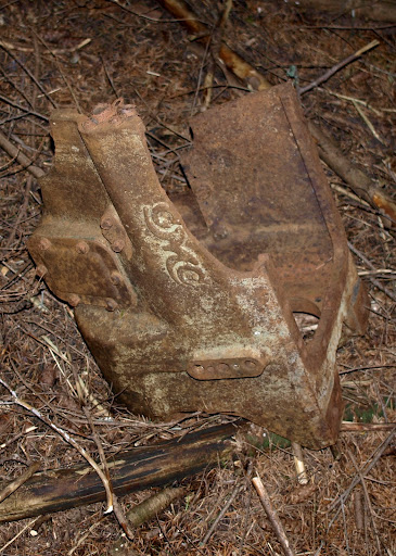
This might be part of the last car (a GMC) to use this road.
There was a nice level stretch at about 2000' with openings that provided a view into the Gorge.
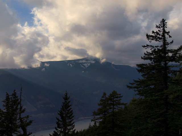
At this point it was still windy but clear and there were even sunbreaks now and then. I was therefore a little dismayed to look out and see clouds beginning to envelope Mt. Defiance. What happened to the happy story about the weather coming in tonight?!
By the time I reached the radio facility, the clouds had blown in, pushed by a steady 20 kt wind with occasional 40 kt punches, and visibility was down to 200' or less. And it had gotten colder. Definitely IFR with deicers from here on.
So if you want to see what the route looks like from the radio facility to Augspurger, go here (SE Ridge).
If you want to see what the route looks like from Augspurger back to the Dog Mtn TH, go here (Trail 4407).
It started snowing in little ineffectual fits as I descended Tr 4407, but got into rain just before the Dog Mtn trail junction. The last 2.5 mi back to the TH were a bit soggy. But today's weather - good in the morning, so-so in the middle, and crappy at the end - didn't stop me from doing what would be a fun loop in nice weather. It's 15 mi, with 4200' EG, but the terrain is pleasantly varied and there are views.
Augspurger Mtn (Full Loop) 14-Jan-2012
Last edited by VanMarmot on June 5th, 2013, 5:22 am, edited 1 time in total.
- Eric Peterson
- Posts: 4097
- Joined: May 11th, 2009, 5:39 am
- Location: Oregon
- Contact:
Re: Augspurger Mtn (Full Loop) 14-Jan-2012
Wow, totally awesome Bruce!
Can you e-mail me your track? Or do you use GPS Fly? Tracks can be uploaded there then
offloaded from users interested in using them
Very cool route that I would love to check out at some point!
Can you e-mail me your track? Or do you use GPS Fly? Tracks can be uploaded there then
offloaded from users interested in using them
Very cool route that I would love to check out at some point!
Re: Augspurger Mtn (Full Loop) 14-Jan-2012
Ditto what Eric said!!
- Born2BBrad
- Posts: 1086
- Joined: May 1st, 2011, 7:26 pm
- Location: The Dalles
Re: Augspurger Mtn (Full Loop) 14-Jan-2012
Hey VM, I'm glad you got a chance to take that route. The view is not as good as Dog Mountain, but you get more solitude. Word of warning, in summer, that route is overgrown with poison oak for the first mile or so.
In your opinion, how safe did you feel walking on Hwy 14?
BTW EP and Guy, that route is the #2 option I was thinking about for the 1/2/12 secret hike.
Brad
In your opinion, how safe did you feel walking on Hwy 14?
BTW EP and Guy, that route is the #2 option I was thinking about for the 1/2/12 secret hike.
Brad
Make now always the most precious time. Now will never come again.
- Jean Luc Picard
Link to GPX tracks
Link to Trip Reports
- Jean Luc Picard
Link to GPX tracks
Link to Trip Reports
Re: Augspurger Mtn (Full Loop) 14-Jan-2012
EP - I just sent you the GPX.Eric Peterson wrote:Wow, totally awesome Bruce!
Can you e-mail me your track? Or do you use GPS Fly? Tracks can be uploaded there then
offloaded from users interested in using them
Very cool route that I would love to check out at some point!
Re: Augspurger Mtn (Full Loop) 14-Jan-2012
Early on a Saturday morning, 14 wasn't bad at all - I stayed left and tried to get past the few narrow sections between traffic so I wouldn't get squeezed. Traffic was light so many drivers had some room to give me room.Born2BBrad wrote:Hey VM, I'm glad you got a chance to take that route. The view is not as good as Dog Mountain, but you get more solitude. Word of warning, in summer, that route is overgrown with poison oak for the first mile or so.
In your opinion, how safe did you feel walking on Hwy 14?
BTW EP and Guy, that route is the #2 option I was thinking about for the 1/2/12 secret hike.
Brad
- Eric Peterson
- Posts: 4097
- Joined: May 11th, 2009, 5:39 am
- Location: Oregon
- Contact:
Re: Augspurger Mtn (Full Loop) 14-Jan-2012
Cooll VM, thanks for sending that!
- Splintercat
- Posts: 8333
- Joined: May 28th, 2008, 10:03 pm
- Location: Portland
- Contact:
Re: Augspurger Mtn (Full Loop) 14-Jan-2012
Wow, I'm impressed, Van -- 3 miles walking on Highway 14..? That's intense!
Tom
Tom
Re: Augspurger Mtn (Full Loop) 14-Jan-2012
Only way for me to do this loop solo. Just had to lean into the air blasting from the 18-wheelers. You could do a shuttle - there's limited parking along the Cook-Underhill Road.Splintercat wrote:Wow, I'm impressed, Van -- 3 miles walking on Highway 14..? That's intense!
Tom
Re: Augspurger Mtn (Full Loop) 14-Jan-2012
Nice work, VM! Another variation along your route is to go bag the summit of Cook Hill (ironically named a hill despite being slightly higher than Dog Mtn), Augsperger and Dog Mtn for a triple summit day. I call the route "The CAT & The Dog" (CAT = Cook-Augsperger Traverse). Sans shuttle the triple summit variation is about 15mi and 5400' gain. Good conditioner.