
A couple of weeks ago I decided to hike in to get some more photos of 4 mile falls along the Eagle Creek trail. The stream was very high at that time - too high to wade the usual spot. So I did something different. I waded in directly down-stream from 4 mile bridge, onto the large island in the stream, hoping to find an easier way to avoid the white water on the other side of it.
Well, low and behold, inthe middle of that island is an old steel bridge, all twisted and mangled from some huge flood most likely! And I mean it is a real bridge - some 30 or more feel long, lying on its side amidst all the trees and other foliage, completely hidden from view from the current trail. Anyway, for Splintercat - it answers the question of why there is an old - blasted section of trail on the east side of 4 mile bridge leading down to no-where. There was once a bridge...that has now been washed away! I would include a photo, but don't have a way to at the moment (galleries are on the way?). But anyway, for those interested in hiking memorabelia - it's a pretty cool thing to check out.
I do want to warn folks about the crossing to 4 mile falls in high water though. I ended up making it that day - but had to be extremely careful!! That is a highly dangerous river crossing in deep, fast, water, with large smooth stones beneath, and no safe wash-out areas. There is not an easy, or very safe way. Only very experienced river-crossers should attempt it. Four mile is a beautiful falls, but not worth drowning for! Getting to the island is not bad, but the other side over can be!
-Zach
Old Bridge near 4 mile bridge on Eagle Creek

Re: Old Bridge near 4 mile bridge on Eagle Creek
Marc Adamus told me that its possible to cross on the logjam a little ways downstream from there and not get wet. At least it was at one point.
-
Splintercat

- Posts: 8333
- Joined: May 28th, 2008, 10:03 pm
- Location: Portland
- Contact:
Re: Old Bridge near 4 mile bridge on Eagle Creek
Hey, Zach - great detective work! The bridge has been in the current spot since I first hiked Eagle Creek in the mid-1970s, I'm fairly certain. So a likely explanation is that the original bridge washed out in the colossal 1964 Christmas Flood. This was he flood that reshaped a number of rivers in the region, and washed away many homes, rolled bulldozers like boulders and nearly crested into downtown Portland. It was a big event, and a lot of the big old logs that you see piled impossibly high above the rivers today were left there by the '64 flood. Since I was just two at the time, I don't have any photos... 
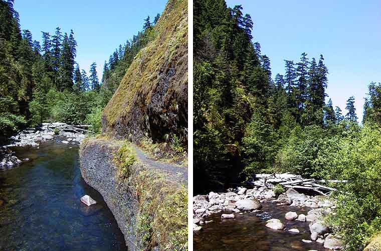
But I DO have these photos from 2001, showing what is apparently the old bridge location (left), plus the logjam downstream (right, zoom). Is the bridge wreckage behind the pile of logs in this view?
Good work, Zach! Lots of stories out there in the canyons..!
BTW, I have never been able to find photos of the relatively substantial lake that formed behind the giant rockslide on Tanner Creek in the late 60s or early 70s (below Wahclella Falls). The Lowes have documented it in their books, and the "lake" shows up on topos from the period. But I've never seen before or after photos of the actual slope and stream section where the slide hit. One more mystery to track down...
Tom
Re: Old Bridge near 4 mile bridge on Eagle Creek
Brian,
Yes, the log-jam downstream is the safest route in the area. In high-water though, there is no longer a dry way to cross. There used to be - there was an additional log downstream, but the current seems to have removed it. The log-jam does get you past a lot of the white-water, but even on the other side, when the river is high, it's a tricky crossing now.
The recent weather has no doubt made it a lot safer, and it will probably remain so for the rest of the summer. I don't recommend it in high water anymore however. To visit 4 mile in full flow now, it's safer to cross the bridge, follow the game trails up and over from the camp-sites, and set up a rappel from above. (BTW - upper 4 mile canyon is fantastic! - Incredibly photogenic - I'll post photos when I'm able.)
-Zach
-
Stevefromdodge

- Posts: 2508
- Joined: May 28th, 2008, 10:03 pm
Re: Old Bridge near 4 mile bridge on Eagle Creek
Are you guys thinking that the old bridge crossed Eagle Creek from the end of the dead end spur? Then when they replaced the bridge, they moved it a bit upstream?
I guess that makes sense.
I guess that makes sense.

Re: Old Bridge near 4 mile bridge on Eagle Creek
Zachchameleon wrote:Brian,
Yes, the log-jam downstream is the safest route in the area. In high-water though, there is no longer a dry way to cross. There used to be - there was an additional log downstream, but the current seems to have removed it. The log-jam does get you past a lot of the white-water, but even on the other side, when the river is high, it's a tricky crossing now.
The recent weather has no doubt made it a lot safer, and it will probably remain so for the rest of the summer. I don't recommend it in high water anymore however. To visit 4 mile in full flow now, it's safer to cross the bridge, follow the game trails up and over from the camp-sites, and set up a rappel from above. (BTW - upper 4 mile canyon is fantastic! - Incredibly photogenic - I'll post photos when I'm able.)
-Zach
For now you should be able to use the Upload Attachment option on the bottom of the message window. there is a limit to the SIZE of the photo you can upload - so if you have trouble uploading that might be the problem.
Re: Old Bridge near 4 mile bridge on Eagle Creek
Thanks Jeff,
I'll post some 4 mile pics soon then. Steve - Yeah, I'm thinking that the bridge must have been placed at the end of that run-out there. You should take a look at it sometime. It was pretty amazing to me that something that large was just sitting over-grown in the middle of that island! Its a large steel bridge, all twisted up. It blows my mind to think of a flood up there with enough power to do it, but it obviously did! Afterward, they must have established that up-stream just a bit was a more stable placement option when building the "new" bridge. (Kind of disappointing they just left the old one! But I guess with something that large, what are ya going to do? At least its out of sight.)
-Zach
-
Splintercat
- Posts: 8333
- Joined: May 28th, 2008, 10:03 pm
- Location: Portland
- Contact:
Re: Old Bridge near 4 mile bridge on Eagle Creek
That seems to be pretty common, Zach - just offhand, I can think of the old bridges on Tanner Creek and Cold Spring Creek that are still lying where nature left them. In both cases, they are wood structures, so eventually they'll melt away.
Tom
Tom
-
Don Nelsen

- Posts: 4380
- Joined: May 28th, 2008, 10:03 pm
- Location: Vancouver, WA
Re: Old Bridge near 4 mile bridge on Eagle Creek
Zach,
Good work with the report and thanks for bringing up the topic of that old bridge. I agree with Tom that it's probably a relic of the destruction of the Dec. '64 flood. It predates my paying attention in that part of the gorge so I don't remember for sure.
Here's some history:
I remember well Dec. of '64 but don't have any photos from the gorge. One thing I do remember was the 6 degrees on the thermometer on the porch of my home in Irvington on the morning of Dec. 17th (give or take a day) and the two foot drifts. Here's a pic I took looking north where the road goes under I-84 on the east bank of the Sandy River in a later storm (Dec. of '68) that was not as bad as the one in '64: You can well imagine what it looked like farther up the gorge in '68 but especially in '64.

When snow of such epic proportions melts off in a couple of days of torrential and warm rains the result in interesting, to say the least. Eagle Creek can get some amazing action and the most recent really destructive event was in '97.
Here's a few pics of what the '97 flood did to the bridge (now replaced with a higher suspension bridge) near the start of the trail and the trees along the bank:The bridge completely disappeared. I guess it ended up in the deep water behind the dam but I don't know for sure:

Here's the view from the trailhead:

And here's what it looked like a a couple hundred yards up the trail. Note the scars on the trees from the flood-bourne debris:

So, the above flood wasn't too big a deal and look what it did - you can imagine what a real flood did to the bridge you found. (BTW, this last flood moved a bunch of rocks and trees on the island at 4 mile - you used to be able to get there withought getting your feet wet on both logs and rocks - they just went on downstream in '97.)
Also, here's what the road looked like immediately west of Multnohmah Falls lodge in '96:


And here's the kind of snowdrifts we got in'97. This was taken at the Oneonta Gorge trailhead over a month after the last snowfall that year:

One June 1st, there was still some left - might be a record for snow at sea level:

- Don
Good work with the report and thanks for bringing up the topic of that old bridge. I agree with Tom that it's probably a relic of the destruction of the Dec. '64 flood. It predates my paying attention in that part of the gorge so I don't remember for sure.
Here's some history:
I remember well Dec. of '64 but don't have any photos from the gorge. One thing I do remember was the 6 degrees on the thermometer on the porch of my home in Irvington on the morning of Dec. 17th (give or take a day) and the two foot drifts. Here's a pic I took looking north where the road goes under I-84 on the east bank of the Sandy River in a later storm (Dec. of '68) that was not as bad as the one in '64: You can well imagine what it looked like farther up the gorge in '68 but especially in '64.
When snow of such epic proportions melts off in a couple of days of torrential and warm rains the result in interesting, to say the least. Eagle Creek can get some amazing action and the most recent really destructive event was in '97.
Here's a few pics of what the '97 flood did to the bridge (now replaced with a higher suspension bridge) near the start of the trail and the trees along the bank:The bridge completely disappeared. I guess it ended up in the deep water behind the dam but I don't know for sure:
Here's the view from the trailhead:
And here's what it looked like a a couple hundred yards up the trail. Note the scars on the trees from the flood-bourne debris:
So, the above flood wasn't too big a deal and look what it did - you can imagine what a real flood did to the bridge you found. (BTW, this last flood moved a bunch of rocks and trees on the island at 4 mile - you used to be able to get there withought getting your feet wet on both logs and rocks - they just went on downstream in '97.)
Also, here's what the road looked like immediately west of Multnohmah Falls lodge in '96:
And here's the kind of snowdrifts we got in'97. This was taken at the Oneonta Gorge trailhead over a month after the last snowfall that year:
One June 1st, there was still some left - might be a record for snow at sea level:
- Don
"Everything works in the planning stage" - Kelly
"If you don't do it this year, you will be one year older when you do" - Warren Miller
"If you don't do it this year, you will be one year older when you do" - Warren Miller
-
Splintercat
- Posts: 8333
- Joined: May 28th, 2008, 10:03 pm
- Location: Portland
- Contact:
Re: Old Bridge near 4 mile bridge on Eagle Creek
Great photos, Don! There's a surprising lack of documentation on the '64 flood. The State of Oregon has compiled this brief overview and there are a few other scraps out there, but it has largely been forgotten!
Tom
Tom