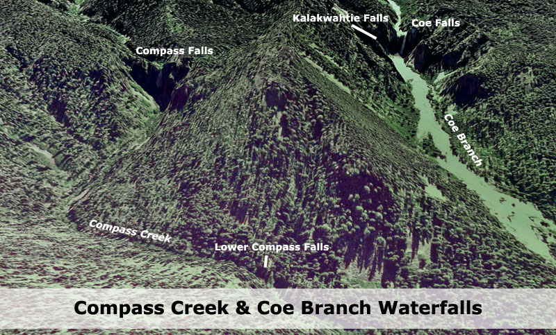
Compass Creek Falls, and more 7-31-2011

Discussions and Trip Reports for off-trail adventures and rediscovering lost trails
User avatar
Koda
Posts: 3466
Joined: June 5th, 2009, 7:54 am

Compass Creek Falls, and more 7-31-2011

Post by Koda » August 1st, 2011, 5:04 pm

8.5 hours round trip starting from the Elk Cove trail-head. There must have been quite a party at the campsite there. I hiked up to 4800 feet elevation on the trail. This is the point I decided would be my entrance into the canyon. Last year, I hiked all the way up to the Elk Cove creek and dropped in there where the brush proved impenetrable in places and steeper terrain.
route2010.jpg
red: my route 2010
Yellow: possible routes I never took
Solid Blue: tributary creek (where unnamed falls are)
I was excited to find my approach via 4800 ele mark to be less steep and little brush in the way. Mostly heavy timber hillside forest with lots of blow-down. A couple of well used elk trails made for more efficient hiking in places. This is the way into the canyon for any future trips.

Once at the bottom, the creek flows right next to the canyon wall. Creek is flowing strong about knee/thigh deep at the most. $10 aqua shoes from Dicks Sporting kept my boots dry for the crossing. Once across my plan was to follow the creek bed upstream. Not so easy, the valley floor here is grown in thick with impenetrable brush. I followed along the creek, but not too long ran into brush. I charged in and found myself crawling in places. Way too thick in here, if I had much more of this I would not make any objectives. Luck gave way to an opening, this valley floor is one huge debris pile from storm damage years ago. big boulders washed down by what I imagine a glacial burst from above. From my new opening, a dry portion of a stream bed allowed easy rock hopping/scrambling way up the canyon where the brush lessens and opens up. My goal was to hike up canyon to 4200 ele, then traverse over to Compass Creek.

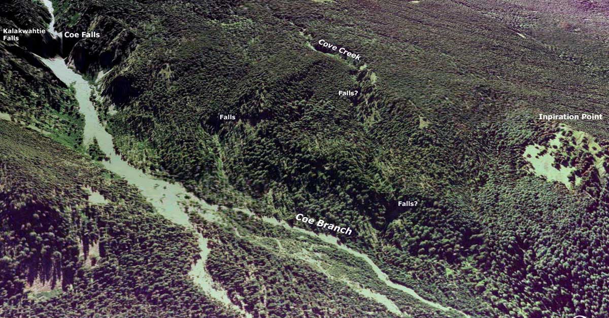
As I arrived at my way-point, I noticed the deep bass sound of Coe Falls. From here you can get your first glimpse of Coe Falls... it did seem odd the sound was so vibrant. I didnt think it could be this loud so close so.... To the west I spotted whitewater pouring in full force, vertically... the real source of the sound of a waterfall. I detoured a bit for a better view and behold, this was a gigantic waterfall flowing in full force through a cliff band on the ridge. I took a few pics, this confirms Splintercat’s falls on the Elk Cove Creek that flows. However, this would be a tributary of Elk Cove Creek, the same one I crossed a year ago higher up descending into the canyon from that point. I am glad that trip, I decided NOT to descend that creek bed itself and realize now how lucky I was that trip to not get cliffed out. The terrain in this portion is much steeper than any topo map shows. This falls is flowing so strong, I can suspect it might not be seasonal. Last year crossing the stream above I remember and noted it flowing strong too. If it’s seasonal, it would be on only the driest drought years. Another thought... since this is not Elk Cove Creek itself... are there any falls over there? No time to explore... off too Compass Creek.
IMG_7624-100.JPG
Elk Cove Creek Tributary falls
Both falls in one view, Coe and the Unnamed one...
IMG_7631-100.JPG
Coe Falls on the left, unnamed tributary falls on the right
I crossed the flood plain and entered timber traversing the 4200 ele roughly. My initial thought was to traverse to Compass Creek and hike up proper, but terrain and blow-down kept me well above the creek. As I arrived closer to the creek itself, the terrain getting down to it got steep... and too brushy. With my target still upstream, I kept on this higher path for much easier travel. At this point, though I wondered if the lower falls would be boxed in with steep terrain and impenetrable brush. Climbers left of the creek shows steeper terrain + recon photos from other trips gave me the possibility of cliffs along that edge. Topo maps show less topography climbers right... in the end, climbers right of the creek was indeed the best choice, but the terrain has more topography on both sides than any topo map shows. The deeper I went, the steeper and rough it got. From here on out would be the toughest portion of the hike. I decided to try and hug as close to the creek, heavy brush and steep drops to water level kept it out of view, but I kept it in earshot. I was very near the elevation of the lower falls and I was suspecting that I would not get any opportunity to find it in here. But then, it just appeared. Not only that, but I had simply walked straight up on it perched on a ledge with a full frontal overlook about midway up the falls height. There is a small amphitheater it flows into in perfect waterfall form. Super green vegetation at the base, this is a very photogenic falls. This was a surprise to me as my imagination had me thinking this falls would not be so dramatic or scenic... more of a large cascade rather than a pure vertical drop.
IMG_7637-100.JPG
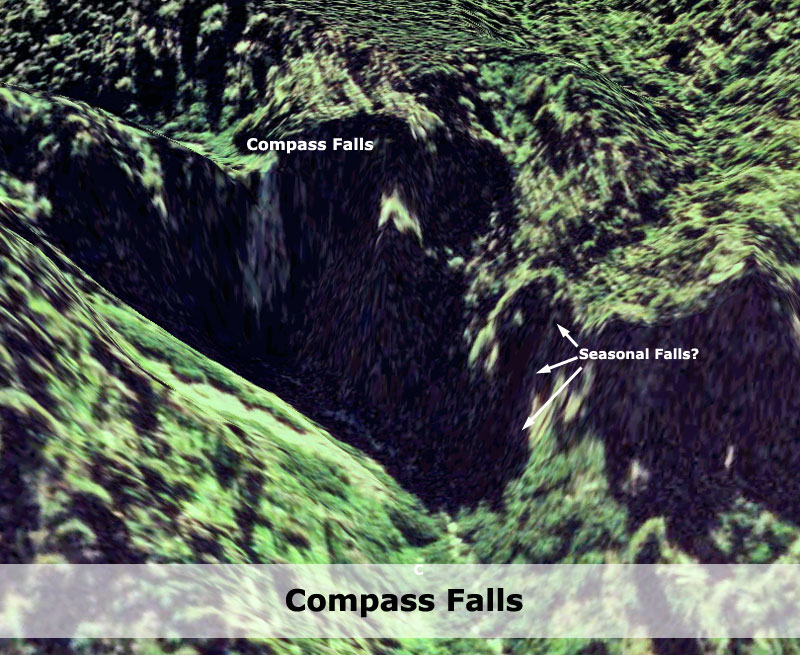
lower Compass Creek Falls
With some rope or some steep scrambling, it looks like one can get about anywhere in the amphitheater, but I was pleased with the up close full view I had.

the right side of the lower falls is made up of cliff and rock, the forest further right is the bottom of a steep bowl with thick thorny brush on its slope. Immediately adjacent to the rock buttress is a rocky laden steep chute... up I went blindly, this was the only way. Climbing this was with all fours in places. This chute though shot straight up the hill and barely cleared the thorny brush slope. Up top, above the falls it was more bushwhacking up creek. Up here is easier access to the creek bed, and thus easier scrambling along creek side in places. Compass flows much cleaner than Coe... and is more attractive in this spot. Its not long though the terrain once again steepens climbers right. Its either climb up and hike above creek, or go right up the creek bed. Looking upstream here showed yet more brush closing in on the stream bed. I chose to stay in the timber. The way I should have gone was right up the creek bed, for full access to the amphitheater of upper Compass. I was quickly cliffed out getting looking down to the creek bed along with heavy brush. But I had my full frontal view of Compass Falls and its huge amphitheater. My endpoint did not disappoint. I was out of time and strength and low on water to dig up the energy to re-route and finish the last bit to the base of the falls.
IMG_7648-100.JPG
upper Compass Creek Falls
I had printed a copy of the two black and white photos from the previous threads <hyperlink>. From my vantage point, I was able to identify the exact photo that was... is this waterfall. The original photographer must have made his way directly up the creek bed, his photo angle the only difference with what I was looking at in person. This was really cool to me to be standing here comparing a live scene with an old B/W photo. I cannot imagine what it took from the original photographer to haul that old photography equipment up here. I was wiped out and exhausted and in no mood to trick my point and shoot into any waterfall smoothing effects. I was past the end of my rope for this much heavy bushwhacking... . I ate lunch and rested.

My return trip is obviously the same with just a few events worth noting. About 15 minutes I came within 10 feet of a elk calf that sprang to life and scared the daylights out of me. Beautiful animal though. The next challenging part was finding my chute at the lower falls. My Garmin was proving difficult reception and I was not exactly on my original path, in this terrain deviating even just a bit is a big deal to correct. Climbing down the chute I made a mental note from now on to always bring a rope exploring waterfalls. Descending steep terrain is much more difficult going down. This was the most precarious moment holding on to pine boughs, ferns, surrounded by thorns. I slipped, a firm hold on a branch anchored me.. every move was not made without a confident hold, but my right knee dug into some thorns. Carefully down the chute, puts you back at the viewpoint of the lower falls. its really cool to stand that close to it, all that water flowing mid air right next to you. Back at Coe Creek in the valley floor I followed my dry creek bed path till I had no choice to crawl thru the brush. Still a ways from my crossing way-point, I decided something different, to move directly into Coe creek and leave my water shoes on. Impossible if you want to keep your feet dry, but the aqua shoes allowed good hiking on the rocks and boulders. If I had to come up this way again, i would just hike up the creek bed this way, rather than keeping my feet dry and swimming in the brush. I made good time getting to my crossing way-point. I must have crossed the creek 7-8 times though. All that, much easier than clawing through the brush. Back at the crossing... I ran out of water. What saved me is my emergency Aquamira Filter straw. My first time using this... and it worked so well. My only inconvenience was not having my hydration tube. I filled my reservoir with cloudy creek water, and anytime I needed water, which was a lot getting up the canyon, I had to stop and drink from the straw from the bladder. I was parched between drink stops... but at least I had water. The filter did a great job with the silty water too, the drinking end was crystal clear water... cold too.

By coincidence, this hike is exactly the same day a year ago when I hiked into Coe Falls...

*edit to fix a missing hyperlink I forgot to add. **edit again to add this edit comment :)
Attachments
Selection_001.jpeg
old photo comparison side by side. I am curious to the date of the b/w photo?
Last edited by Koda on August 8th, 2011, 5:14 pm, edited 2 times in total.
lightweight, cheap, strong... pick 2

User avatar
Koda
Posts: 3466
Joined: June 5th, 2009, 7:54 am

Re: Compass Creek Falls, and more 7-31-2011

Post by Koda » August 1st, 2011, 8:13 pm

GPS track.
Selection_003.jpeg
and an interesting picture of bolts in a weathered log. I wonder what was built up here needing bolts...
Attachments
Selection_004.jpeg
lightweight, cheap, strong... pick 2

User avatar
Splintercat
Posts: 8333
Joined: May 28th, 2008, 10:03 pm
Location: Portland
Contact:

Re: Compass Creek Falls, and more 7-31-2011

Post by Splintercat » August 1st, 2011, 9:40 pm

WOW! You've outdone yourself, Wayne! Outstanding report! You've not only documented the falls, you've also put the identity to the old photo from Jack Grauer's Mount Hood book. Awesome!

The main falls on Compass is really nice -- great amphitheater and a nice plunge -- and of course, the lower falls is a real surprise. I had imagined a low block-style falls, nothing special. Great find!

One thing your photos from Compass seem to settle is whether a tributary falls drops into the amphitheater, as suggested here:

Image

Doesn't look like it.

The tributary falls downstream from Coe Falls is very cool, too -- as I understand your report, it's the nearest falls to Coe in this schematic:

Image

I could see that kind of runoff in the unnamed stream if you compare it to what the Yocum Ridge waterfalls produce during the early runoff -- before pretty much drying up. But it looks pretty impressive in your photos -- cool!

Wow... great to see these pics, Wayne! Bravo!

-Tom :)

User avatar
Koda
Posts: 3466
Joined: June 5th, 2009, 7:54 am

Re: Compass Creek Falls, and more 7-31-2011

Post by Koda » August 1st, 2011, 11:05 pm

Splintercat wrote: The tributary falls downstream from Coe Falls is very cool, too -- as I understand your report, it's the nearest falls to Coe in this schematic:
Selection_004.jpeg
rough sketch of routes I used into canyon...
I think your mark is probably right on. I roughly sketched both the routes I used in red. I suspect there are falls on the main stem of Elk Cove Creek... and right about where you labeled them. As I descended the canyon this trip I could faintly hear the creek at times indicating a good flow. There is a lot of terrain in this area that does not show up on any topo, I think that Cove Creek would be a challenge to explore

Here is another interesting shot of Coe Falls zoomed in.
IMG_7629.JPG
Coe Falls zoomed in
From this angle it looks like a small tier above the main lip...

and here is a photo deep in Compass Creek before I arrived at the lower falls. I spied the creek from afar through the brush (center of photo).
IMG_7635-100.JPG
Compass Creek
I cant tell if I was seeing the lip of the lower falls, but looking closer at this pic it does not seem so. A smaller falls?... in this pic it does seem like a drop, but the brush is obscuring everything. This pic gives a good detail of the thickness and amount of brush you have to deal with along Compass.

And here is a zoom in shot of that unnamed tributary falls
IMG_7625.JPG
Cove Creek Tributary falls
lightweight, cheap, strong... pick 2

User avatar
Sore Feet
Posts: 743
Joined: May 28th, 2008, 10:03 pm
Location: Seattle, WA
Contact:

Re: Compass Creek Falls, and more 7-31-2011

Post by Sore Feet » August 1st, 2011, 11:38 pm

Awesome work Wayne. This does raise another question that may necessitate digging into history further. When I found the digital version of the photo in Grauer's book, it was labeled as Wallalute Falls. The book Oregon Geographic Names makes a specific note that residence of Hood River said that Wallalute Falls was on Compass Creek and not the Eliot Branch. It also states the falls were named in 1893, the same year the picture of Stranahan's Falls was taken - and only discovered the year prior. I'm gonna go out on a limb here and say the USGS has the wrong waterfall marked as Wallalute Falls, and that Stranahan Falls may be the legitimate name of the falls on the Eliot Branch.

User avatar
BrianEdwards
Posts: 2405
Joined: February 2nd, 2010, 1:32 am
Location: Oregon City, OR
Contact:

Re: Compass Creek Falls, and more 7-31-2011

Post by BrianEdwards » August 2nd, 2011, 5:41 am

Great job Wayne. Lower Compass is a shocker. Never expected it to look like that. You've successfully bagged all the big falls in this drainage, congrats!
Clackamas River Waterfall Project - 95 Documented, 18 to go.

User avatar
Koda
Posts: 3466
Joined: June 5th, 2009, 7:54 am

Re: Compass Creek Falls, and more 7-31-2011

Post by Koda » August 2nd, 2011, 8:22 am

BrianEdwards wrote:Great job Wayne. Lower Compass is a shocker. Never expected it to look like that. You've successfully bagged all the big falls in this drainage, congrats!
Maybe you and I can work on another waterfall project. I almost stayed home Sunday, but realized that Compass was calling my name and I better take advantage of my hall pass. I was hoping you could join me on this one Brian... I've never been much of a solo hiker, and then there's the whole safety thing. It was a fun hike though, but I grew weary of the constant climbing over and crawling under all the blowdown. Compass Falls is a long way in.

Sore Feet wrote:Awesome work Wayne. This does raise another question that may necessitate digging into history further. When I found the digital version of the photo in Grauer's book, it was labeled as Wallalute Falls. The book Oregon Geographic Names makes a specific note that residence of Hood River said that Wallalute Falls was on Compass Creek and not the Eliot Branch. It also states the falls were named in 1893, the same year the picture of Stranahan's Falls was taken - and only discovered the year prior. I'm gonna go out on a limb here and say the USGS has the wrong waterfall marked as Wallalute Falls, and that Stranahan Falls may be the legitimate name of the falls on the Eliot Branch.
I would love to know about the names once figured out. It sounds like upper Compass is really Wallalute, and the falls on the Eliot is really Stranahan Falls. But as it stands the upper falls on Compass is technically named Stranahan? Is he the guy in the old B/W pic or the Photographer, discoverer? A google search for Stranahan turned up Oscar L. Stranahan 1834-1910... the article only briefly mentions he explored much of Hood River and the vicinity of Mt Hood, and mentions a business partnership with H.C. Coe.... Could this be the Stranahan the falls were named after? Maybe Coe was his exploring partner as well (Coe Creek/glacier?) The fun part of this hike was knowing there is a historical link to the falls. I can see how if this guy was the first to document these falls the names could get mixed up over the years, and if the pic was taken in 1893 he would have been 59 years old and I'd bet he didn't have a trailhead to park at... impressive.

I looked up Grauer's book on Amazon but it was out of stock.
lightweight, cheap, strong... pick 2

User avatar
Charley
Posts: 1838
Joined: May 28th, 2008, 10:03 pm
Location: Milwaukie

Re: Compass Creek Falls, and more 7-31-2011

Post by Charley » August 2nd, 2011, 9:10 am

But, did you find D.B. Cooper?
Believe it or not, I barely ever ride a mountain bike.

User avatar
Sore Feet
Posts: 743
Joined: May 28th, 2008, 10:03 pm
Location: Seattle, WA
Contact:

Re: Compass Creek Falls, and more 7-31-2011

Post by Sore Feet » August 2nd, 2011, 11:24 am

Koda wrote:I would love to know about the names once figured out. It sounds like upper Compass is really Wallalute, and the falls on the Eliot is really Stranahan Falls. But as it stands the upper falls on Compass is technically named Stranahan?
No, currently it is assumed the falls on the Eliot Branch is Wallalute Falls and the falls on Compass Creek is not officially named (so just Compass Creek Falls). There is an 1893 photo of the falls on the Eliot Branch captioned as "Strawnahan's Falls", and then there's the photo of the falls on Compass Creek captioned as Wallalute Falls. The question is which one was taken first. If the Compass Creek photo was taken before the Eliot Branch photo, and it was captioned as Wallalute Falls, then we'd know for sure that Wallalute is the name that should be properly applied to the falls on Compass.

User avatar
Splintercat
Posts: 8333
Joined: May 28th, 2008, 10:03 pm
Location: Portland
Contact:

Re: Compass Creek Falls, and more 7-31-2011

Post by Splintercat » August 2nd, 2011, 12:11 pm

I think you've made a really good case for a map error, Bryan. Once that flood of historic USGS topos comes online (in October), we might be able to track the mapping history a bit better for that area. The maps I've got show the Eliot falls as Wallalute back as far as the 1920s.

Wayne, I'm amazed at how close your 2010 route came to the unnamed stream/falls..! You're right about threading the needle on that one, however unintentionally! :D It would be very easy to get cliffed in that area, based on your photos.

Back to the main Compass Falls, what strikes me about this one is how well Google Earth mapped the features around the falls when you compare it to your photo -- much better than I'd expect, given that GE basically drapes air photos over a topo model that seems too generalized to pick up that much detail. I'm thinking about this schematic that I posted awhile back, in addition to the more detailed view, above:

Image

It's a really cool amphitheater -- right up there with Tamanawas Falls in that sense. Very rugged and quite photogenic for a mountain waterfall. Great find!

Oh, and that board with the bolts in it -- there was a substantial footbridge over Coe Creek on the Timberline Trail for many years, I think well into the 1980s. It's long gone, but you might have found a remnant of it, who knows?

Tom

Post Reply