On the lawn of one of the restaurant/hotels, I stood in the middle of my pile of last-minute grocery buys: 2 lbs of lamb shanks (30% off!), a lb of cooked chicken, a 4 lb cantaloupe (2 super-ripe ones were $1! But I managed to give 1 away before I left Portland), 2 lbs of strawberries, 4 bananas, a lb of organic butter, a bunch of celery, a Walla Walla Sweet, 4 lbs of ice, a half gallon of Odwalla carrot juice (keep refrigerated!), two foil-packed Tasty Bite Indian dishes and 2 lbs of gorp... but w/only 8 oz of chocolate M&Ms. I shoveled them into my pack and started tamping. Since I had my tent, stove, filter and pad all strapped on the outside, there was just room... but an exxxxx-tennnnded period of huffing, puffing, straining and rearranging was necessary.
A determined local w/scrawny, starved Simpsons'-Mr-Burns features strode up. "Do you need anything?"
"Am I on your property? I can move."
"This is my hotel, but you're fine." This w/a reassuring smile. "Have you got everything you need?" The guy wasn't Mr. Burns, he was Ned Flanders.
I'd just gone down my checklist. "I didn't bring any insect repellent. They're gonna eat me alive, aren't they? Can I buy that here?"
"Don't need it. We just had a couple sub-freezing nights. Killed 'em all off. That looks like a pretty heavy pack. I bet you'd like a ride to the trailhead?"
I turned him down. Didn't want to admit I wasn't exactly where I'd planned on being. Hoisted my pack... "Ummmph!" Almost tipped over. It was heavier than anything I'd picked up since I flunked out of SFQC. I trudged the mile to the Wallowa Lake Trailhead past guys w/beards and guide-y clothing leading pack animals and dozens of quaint vacation cabins. Mostly elderly couples out for an evening walk waved and said hi to me. By the time I got there, it was barely light enough to fill out the registration.
Set up my tent at the first campsite along the West Fork of the Wallowa River, 3 miles in. Pitch black w/the wind gusting hard enough to send my rain-fly for a 20 yard jaunt before I caught it. Ate a couple of bruised bananas. Took off my sweaty clothes and put on long-sleeved capilene and fleece pants and jacket and raincoat... and crawled into my bag, where I shivered my way through a near-freezing night.
The next morning, Ranger Rick (his real name, he was a summer ranger w/a summer ranger's easy attitude towards uniform ironing and bountiful facial hair) visited. He inspected my registration, where I'd put that I intended to stay 5 nights but didn't know at which lakes. "This is great. Most people don't even TRY to predict where they'll camp." He smirked in a friendly way at the maps I'd downloaded as .pdf's from the USGS website. "USGS quads? Some of these are 40 years old and 30 years out of date." He cautioned me about not making any fires w/in a quarter mile of any of the lakes, told me that federal stimulus money had let the ranger district hire 4 or 5 summer rangers this year so the trails were in great shape, and was on his way.
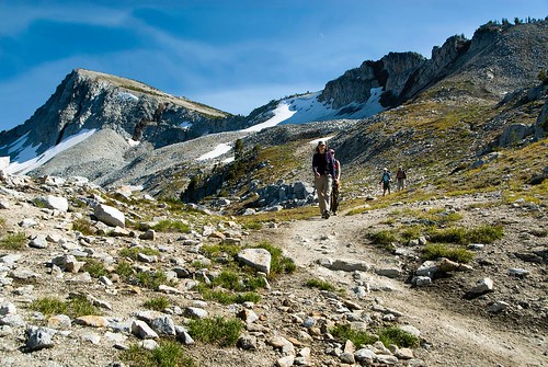
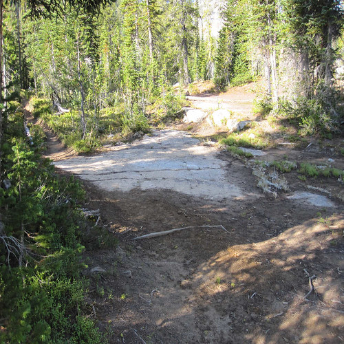
Hiked 3 miles south to 'Six Mile Meadow' and turned west. Crossed the West Fork on logs below the destroyed footbridge.
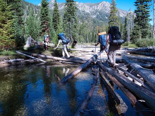
(Photo by MountainGroovePhotography. Mike Warren, from the Seattle Mountaineers group, whom I met on this trip, gave me permission to use these shots that he took the same days that I was there).
After that, went west-southwest for 3 steep miles (1100' gain) until the fork in the trail just before Horseshoe Lake... which I missed 'cause I had my head down trying to catch up w/a couple I saw ahead of me. So I took the 1.5 lakeside choice instead of the 1.3 mile cliff-face option. The views are actually better on the 1.3 mile fork... but it doesn't lead you by any of the campsites at Horseshoe. About a quarter-mile down the trail, I came to a sharp left back to the lake shore, to avoid a marshy meadow. A user-made trail leading off to the right was blocked by logs. I took the left to the lakeshore, where I sat down, took my pack and my shirt off and ate lunch.
(Photo by MountainGroovePhotography)
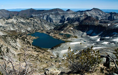
Then, peering at the map, I decided to take a chance and backtracked to the blocked-off user-made trail. I followed it to the north. Aha! Piles of pack-animal dung. Well-trodden. My tracking chops were equal to the task. The knee-deep water of the wetlands quickly took over all the flats, so the trail angled up onto the slope of the ridge and then followed a draw... up to the shorter cliff-face trail I'd missed a quarter mile earlier. You can see the island in Horseshoe Lake on the below map. The user trail connecting the two official trails was directly north of the east end of the island.
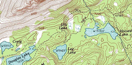
I followed that trail for another 3 miles, past Douglas Lake, to Moccasin Lake.
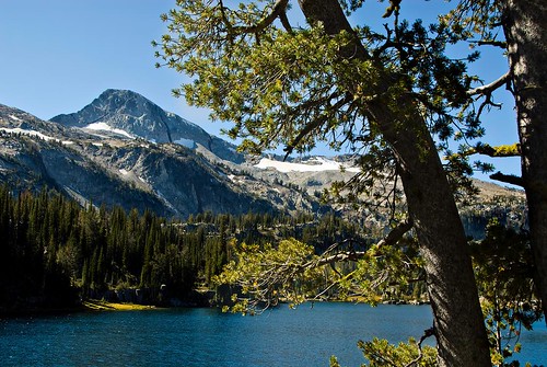 Photo by MountainGroovePhotography
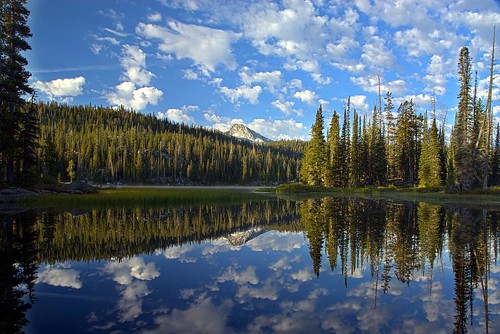
Eagle Cap is reflected in nearby Mirror Lake's waters. Tantalizing! Makes even flat-land-lovers hungry to peak-bag!
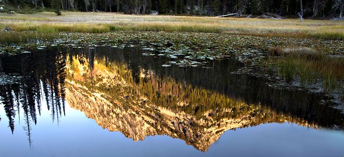 Photo by MountainGroovePhotography
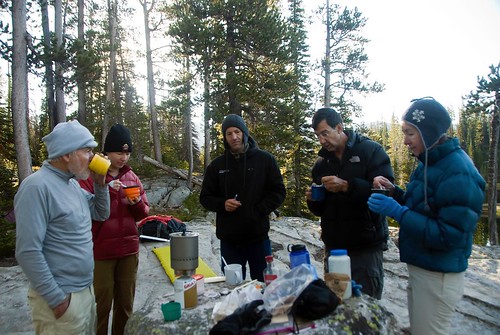
Near there, I met up w/J. and R. -- who were already camped a mile further west, at Upper Lake. They'd had extraordinarily good luck fishing and invited me back to their campsite to pitch a tent and share dinner. At Upper Lake, I sighed loudly as I laid my horribly pregnant backpack down and jettisoned my ice bag (half ice, half water by that time, even though I'd kept it in a stream overnight). First the tent had to go up, just in case some weird weather blew up out of the clear, blue skies. Then I fired up my heavy jet-afterburner MSR stove and cooked the lamb in butter. "Pan frying. That's not how I usually cook lamb." R said. "But it works," he added hastily, horking down his share. Next time, I'll pack in a 10 lb cast-iron Dutch Oven for the sake of all you pan-frying haters.
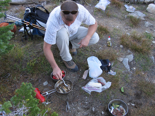
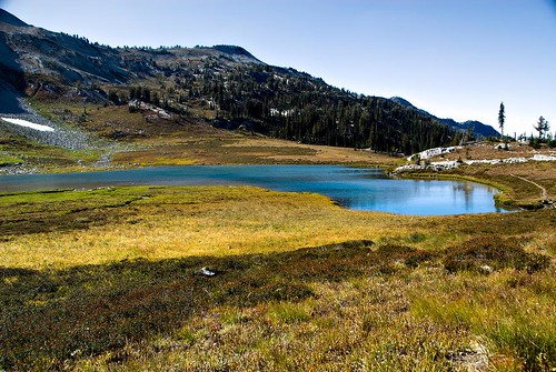
Photo of Upper Lake by MountainGroovePhotography
We had company, of course. Camp robbers, and chipmunks?/ground squirrels?
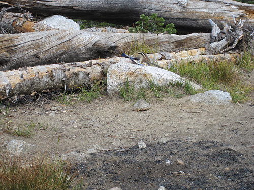
Nothing bigger. I hung my food bags but J. and R. had a new carbon-fiber Bearikade canister from Wild Ideas and didn't need to.
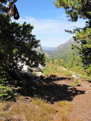
You can see the East Fork of the Lostine River valley in the background.
That night, after the alpenglow had faded, we saw headlamps descending from Eagle Cap. "It looks like we're gonna get to see a fatality, maybe," R. commented. The lamp-wearers were practically running down the trail. 5, 6, 7 or more people appeared to rocket along 3/4 mile of trail in just a few minutes. Nobody fell, so could be it was just a misjudgement of the distance on our part. We guessed they'd been up on the mountain to view the alpenglow and the sundown and the amazing stars.
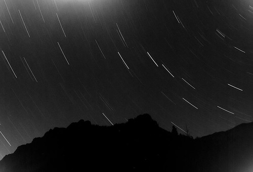
Star trails over Sacagawea by MountainGroovePhotography.
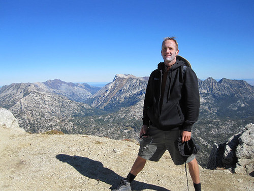
Next morning, J. and R. and I hiked up that same trail to the top of Eagle Cap (9,573'). It's a freakin' highway. So maybe people were running down it.
Great views from the top. Glacier Lake directly beneath Eagle Cap, to the east.
(Photo by MountainGroovePhotography.
Matterhorn and Sacagawea peaks to the north east.
Matterhorn has the white, steep, fierce looking face. On it's backside, it's an easy scramble up from Ice Lake.

Photo by MountainGroovePhotography.
On the way down, we met a group from the Seattle Mountaineers: Mike, Cherie, Heike, David, Cebe and Sarah. When they came back down a couple hours later, they stopped at Upper Lake to eat lunch. I wandered over and wangled an invitation to bring my plastic flask of Bushmills to their camp at Horseshoe Lake for dinner and drinks that night. "Right here! Across from the little island!" Heike pointed out where they were w/a little twig. After a couple hours, I followed them down the trail, at a jog, with a pack holding fresh veggies for dinner makings and a jacket and headlamp. J and R looked at the map and declined to join me, "You know that's 4 miles from here, right?"
Dinner was good. The conversation was good. The booze was good -- if you don't mind Monarch 151. Monarch being the generic sell-to-the-bar-trade-for-well-drinks label that Hood River Distillery uses. Since HRD is a local product, I will confine myself to glowing praise of the great value they deliver for a low, low, low price. But it's definitely not my first choice for sipping w/out ice. David and Cherie and Heike jammed hero-worship stories about Cebe's climbing and writing prowess down his throat. "Look! We were traversing, going to traverse an ice-field w/a 45 degree slope, and Cebe stopped me. I was holding my ax at my chest, in the self-arrest-ready-position. Cebe stepped out onto the field, holding his ax by its head at his hip and sometimes driving it in to support himself as he stepped. He didn't have to say a word. I could see how easy it was." Cebe, who supervised the writing of Part 1 of 'The Freedom of the Hills' (HELLO! Hiking/climbing BIBLE for the Church of the Outdoors for 40 years), is a friendly grey-bearded legend who refuses to brag and squirms when others insist on doing it for him. And Heike is a German w/in-your-face Deutsche self-confidence -- who enjoyed brashly spreading a thick layer of admiration on every Cebe-Story she told. She made him blush. Like it was his very first time.
Cherie complimented my busy veggie-chopping. Mike was taking some great late-in-the-day-light photos from the little island but he joined us after that. There was much discussion of how many lakes we'd swum in, whether it counted as swimming if the top of your head stayed dry and if 'nude-up' was an actual word. It is. It's in the Urban Dictionary.
Dark was almost on us by the time I felt ready to tear myself away from the happy companionship. I hugged everybody and departed. A couple of miles up the trail... I lost the trail. I wandered off on a side trail. Backtracked and found the main trail again. Did the same thing again. And again. After an hour, I gave up and returned to the Mountaineers camp. All was dark. David and Heike and Cebe sleepily but cheerfully loaned me extra clothing to wear and a tarp to wrap myself in. I was too shy to suggest that I'd be happiest spooning w/them, so I spent a not-nearly-as-uncomfortable-as-you-imagine night looking up at the stars... w/my backpack as a sleeping pad. Still, I was glad when the sun finally rose.
The Mountaineers had the latest Jet-Boil technology, so tea and oatmeal happened about 2 minutes later. My back wasn't too happy at this point. There was a time that sleeping on my backpack wouldn't have phased me. That time is long past.
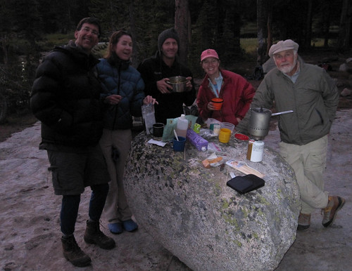
Breakfast at Horseshoe Lake.
David, kind man that he is, noticed that I was having trouble bending over to pick up my dropped cup. "You need a back-cracking." He bearhugged me from behind, lifted me in the air and got FOUR separate vertebrae snap-crackle-pops. It felt SOOOOO good. After gratefully hugging everybody, again, I was off. When I got to where I lost the trail the night before, I immediately understood why. The main trail turned at that point, but there was a user-made trail that continued on straight. People leaving the main trail to find a campsite along the lake there had created a trail and the rangers hadn't had occasion to mark the turn w/a cairn of rocks or block the side trail w/a log. Almost all of the other turns and possible points of confusion on the trail were marked that way.
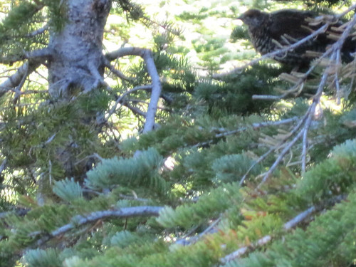
Saw several grouse on the way back.
J and R had pulled up stakes and moved on by the time I got back. I did a day hike alone to Glacier Lake and then moved my tent to Horseshoe Lake. The Mountaineers were gone, so I claimed their campsite. Very grey and cloudy and lonely. And, of course, it rained that night. Thankfully, I'd put up my rain fly. And the weather was clear the next morning. Hiked back out the way I came... but w/a detour to spend a final night up at Ice Lake. The trail up from the West Fork of the Wallowa River to Ice Lake... is a bear. Switchback after switchback after switchback. I overhauled a Polish couple, Tomasz and ?Masza? on the way and happily exhausted my Polish vocab describing the views, "Bardzo dobze!" And saying, "Ja jestem Amerykanskie. Ja nee mowee jenzyk polskiego!" "I'm an American and I don't speak much Polish!" It was their first day in and their top-heavy packs towered 2 meters high. That evening, they took part in an international effort to help me eradicate my last food and the still-sloshing flask of Bushmills.
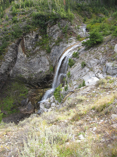
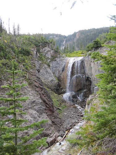
Falls at about the midpoint up the trail.
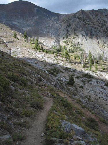
Looking back down the switchbacks in the final leg of the trail.
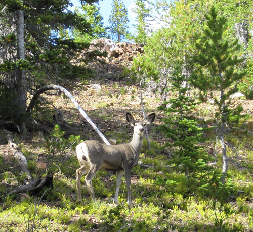
One of several deer we saw on the way up the trail. I'm guessing that I saw them here and no where else because the trail only goes to Ice Lake and has 2000' of elevation gain in less than 3 miles... so there aren't many people on it.
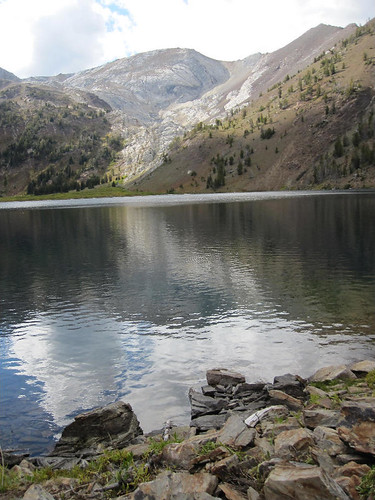
Ice Lake was probably my favorite camp site. It was so lonely up there -- the bird calls echoed across the broad expanse of water. T. and M. and I sipped and talked about how lucky we are in Oregon to have such a beautiful wilderness paradise to glory in.

Looking northeast towards the outlet of the lake from near my campsite.
Looking west towards the Matterhorn.
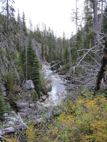
Next morning, I got up and broke down my tent while the sun was still hidden behind the hills to the east and my Polish friends were still snoring. It was barely 8 am by the time I got off the Ice Lake trail and back on the main trail out. Here's a shot of my final views, the West Fork of the Wallowa River.
Back at Wallowa Lake, I caught the county bus into Joseph. The driver, a local, told me about how he'd often hiked up to Ice Lake and the Lake Basin when he was younger and slimmer and how the trails weren't much different now then they'd been 50 years ago. In Joseph, I had a huge omelette and toast and bacon and orange juice at the Cheyenne Cafe, where the service was friendly and the crowd of regulars groused loudly but cheerfully about how dreary the weather had been this summer and the resulting low-volume tourist traffic. I met up w/my bow 'hauntin' buddy at our pre-planned rendevous at and we drove back to Portland.