Day One -- Up the East Fork Wallowa River trail to Jewett Lake (8.5 miles, +3700 ft)
Day Two -- Over Tenderfoot and Polaris Passes, then up the West Fork Wallowa River trail to Glacier Lake (11.5 miles, +2500, -2600 ft)
Day Three -- Over Glacier and Ivan Carper Passes to Minam Lake, then out the West Fork Lostine River (13 miles, +1300, -3800 ft)
Full pictures and commentary at http://texasbb.net/files/Wallowas-2010/
The weather forecast was for varying probabilities of showers and thunderstorms, those probabilities increasing through the three days we would be hiking. It did rain on us while we set up camp the first night, but then it got beautiful for the rest of the trip.
Our first day started with driving at 5:30am. After dropping one car at the Two Pan trailhead and making our way to Wallowa Lake, we hit the trail at 11:23am. By about 3:00pm we passed Roger Lake:

Just a few minutes later we hit Aneroid Lake. Aneroid is a gorgeous lake, but it's a little weird in that there are some private cabins scattered about at its southern end. We stopped only long enough for a few pictures:


One of the things I love about the Wallowas is the amazing geology--so many colors, terrains, patterns. Here's one over Aneroid Lake that reminds me of Charlie Brown's T-shirt:

Our goal for the day was Jewett Lake, another 2.5 miles and about 800 feet, so we pressed on. There's a simply gorgeous meadow not far above Aneroid Lake:

Maybe a quarter mile before the crest of Tenderfoot Pass, we peeled off to the right and headed cross country toward Jewett Lake. It's easy to find, sitting in the obvious bowl ahead:

Jewett Lake is gorgeous, and we were very glad we'd passed on Aneroid Lake to camp here:

Notice the dead tree there? Just behind that is what would be a storybook campsite, were it not for a fire someone let get out of hand.

The rain quit as soon as we got everything set up (of course) and we took in the views for a while before making supper. Here's the view to the north from maybe 50 yards from our camp:


The camp at Jewett Lake gave us what was probably our best view of Aneroid Lake:

Looking at the lake from near our tents:

The next morning we headed out toward Tenderfoot Pass. Here's one last look at Jewett Lake under Pete's Point:

The views from Tenderfoot Pass are fantastic. Here's looking over to the south:

From Tenderfoot Pass it's an easy but exposed but beautiful 2 or 3 miles to Polaris Pass:

Polaris Pass itself has one of the premier views in all the northwest. Here's the big view to the west (sorry for the large pic, but there's just so much to see...)

The view to the west is dominated by light granite and limestone, distinctly different from the browns and grays to the east. You can see that somewhat in this picture taken from a couple hundred yards up the ridge to the south:

Here's a view back to the trail up from the east, with Aneroid Mtn in the distance:

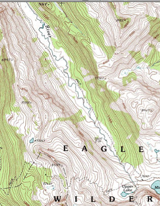
The trip down the west side of Polaris Pass is legendary. On its 2300-ft drop to the West Fork Wallowa River, it folds about five miles of tread into more than 40 switchbacks. If you've never seen this thing on a map, here's a trace to whet your appetite:

Getting down seemed to take days. But we evenutally joined the West Fork Wallowa River trail and made our way up to Glacier Lake. It was still early but we decided to stop here just because it's so pretty. We had the whole place to ourselves.
Glacier Lake from near its outlet:

Eagle Cap over Glacier Lake:

Camp at Glacier Lake:

Looking east-ish over Glacier Lake as the sun sets:

Glacier Lake reflection at dusk:

Sunrise over Glacier Lake:

The next day we continued over Glacier Pass to Moccasin Lake:

Eagle Cap over Moccasin Lake:

Moccasin Lake from the west:

We continued west to Mirror Lake, but couldn't have arrived at a worse time lighting-wise. The sun was nearly overhead and the air was hazy:

From there, it's a semi-steep 1000 feet up Ivan Carper Pass, with gorgeous (if hazy) views all the way. Hurricane Divide (left) and the Matterhorn (just right of center) from trail to Ivan Carper Pass:

Eagle Cap over Upper and Mirror Lakes, viewed from Ivan Carper trail:

Upper, Mirror, and Moccasin Lakes from Ivan Carper Pass:

On the other side of the pass, 1100 feet below, is Minam Lake:

One of the few views of Minam Lake on the way down from Ivan Carper Pass:

We stopped briefly at Minam Lake for a snack and some moleskin, then kicked it into high gear to get out to the car at Two Pan a little before 2:00pm. From there, we picked up the other rig at Wallowa Lake then downed the traditional post-hike bacon cheeseburgers at R & R Drive-In in Joseph, OR: