On Monday, inspired by Peder’s and Andy’s trip report, I decided to give Mt. Whittier a try. I left Portland at 5:30am and got to the Norway Pass TH at 8:00am under clear, cloudless, and rapidly warming skies. The hike up to the junction of the Boundary and Whittier Ridge (#214) trails went smoothly. I hadn’t been here before and the devastation wrought by St. Helens was, even after 30 years, pretty amazing.
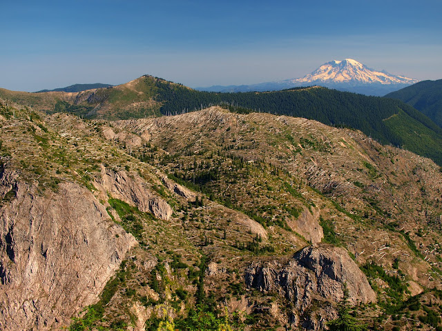
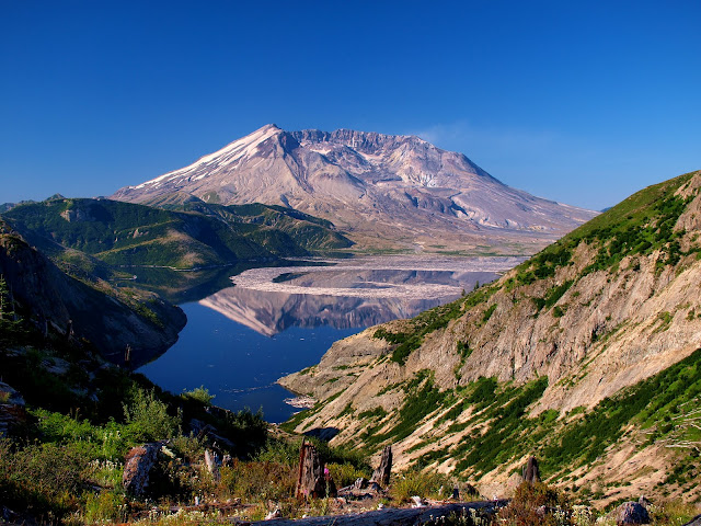
Along the way, I had a nice view of the Spirit Lake, the crater, and what looked like a wisp of vapor coming out of St Helens.
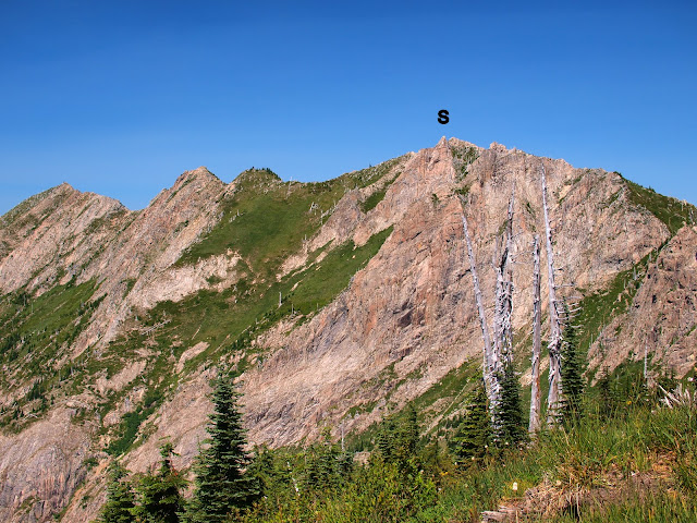
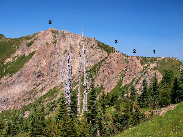
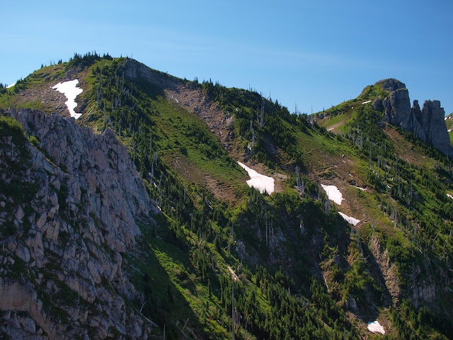
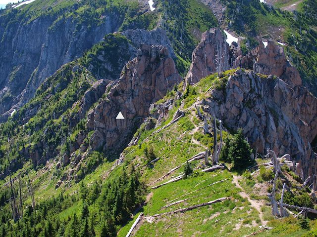
At the Boundary-214 trail junction, I got my first clear view of the Whittier ridge. “S” marks the summit,
and “1”, “2”, and “3” are the towers I would have to traverse to reach it.
I found an old, largely unreadable sign thrown in the trees near the start of the 214 – probably the one that says “proceed at your own risk.” The 214, as it heads north to intersect the Whittier ridge was in OK shape and pretty easy to follow.
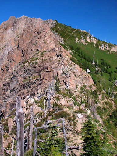
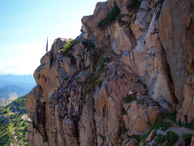
Soon, however, it reached the ridge proper and the scrambling started. Not too hard – but I had to pay attention all the time, both to where the trail was and to my footing. Although I took a couple of wrong turns, the trail was generally pretty evident thanks to the clear sunny skies. It doesn’t leave the ridge (as some confusing goat trails did) and basically passes the 3 towers on their right (E) sides. The arrow (triangle) shows the trail following a wide ledge to the right of the first tower.
It then goes around the second tower the same way – to the right as a wide ledge hewn in the rock.
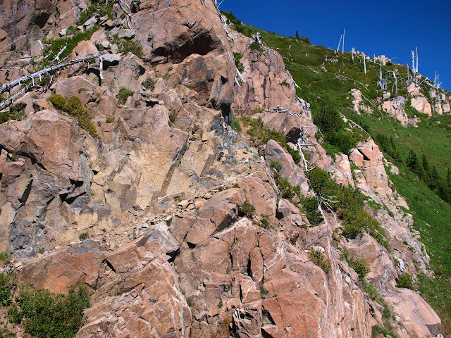
The trail passes the third tower by first going around it on a ledge,
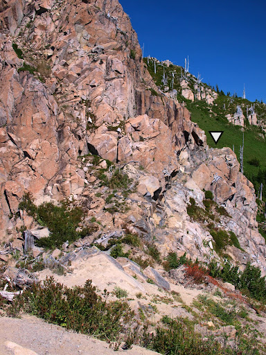
then descending an exposed ramp covered with loose soil and a few loose rocks. Most descriptions of this route consider this to be the crux segment. I agree - it’s not technical but if I’d lost my footing here gravity would probably have written the closing chapter. In my opinion, this segment would not be something to do unaided if it was wet or icy. It amazes me (as it has others) that this is (or was) a formal Forest Service trail!
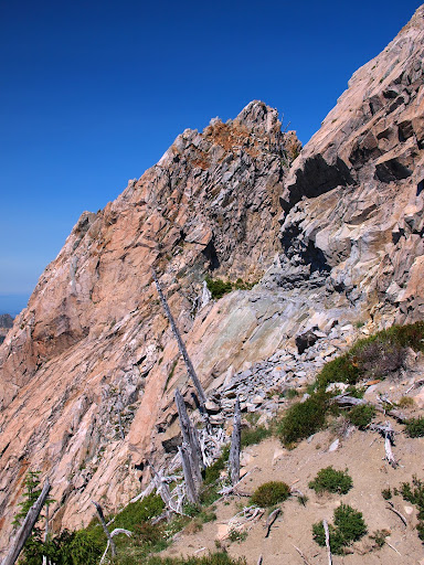
Looking back from higher on the trail gave me a good idea of the exposure in this crux section (just above the triangle (arrow)).
After this section, things mellowed considerably and the trail became (mostly) more like a trail. There were still a few ledges to follow,
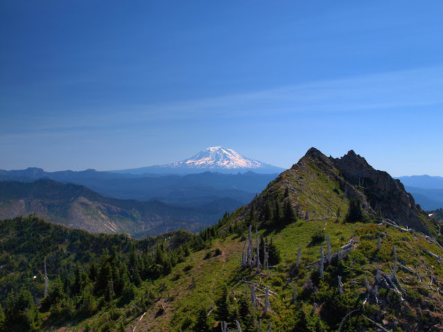
but soon I’d passed the summit and was looking back (S) toward it.
By now it was just past noon and the air temperature was reaching for the 90’s and I was already 3 liters of water down. So I headed back, found some cool, clean, running snow melt at Bear (“bare”) Camp, hit the TH, and was back in Portland by 6pm (including a 45 minute delay while they paved WA 503). Overall, an exciting scramble (it's more than a hike and you have to PAY ATTENTION) with great views. It's a fascinating area - I think I’d like to go back and hike Mt. Margaret when the Fall colors come out.
Mt. Whittier 16-Aug-2010
Last edited by VanMarmot on August 18th, 2010, 10:50 am, edited 1 time in total.
- weathercrazy
- Posts: 1478
- Joined: May 28th, 2008, 10:03 pm
- Location: Battle Ground, Washington
- Contact:
Re: Mt. Whittier 16-Aug-2010
Nice pics...and report! I'm assuming you dealt with a good bit of wind? That was what was producing the dust off of St. Helens. A "volcanic activity statement" was issued for this because many thought the mountain was putting on an eruption.
I've attached the visible satellite picture from that day showing the dust being blown quite some distance by winds 50 mph+
Tyler Mode
http://www.naturespixpdx.com
Re: Mt. Whittier 16-Aug-2010
There must have been stronger winds aloft. Where I was, below 5000' and in the terrain, the wind varied between a moderate breeze and not much. With temperatures heading toward the 90's, I really welcomed what wind I did get (but 50+ mph would have been too much).weathercrazy wrote:I'm assuming you dealt with a good bit of wind? That was what was producing the dust off of St. Helens.
Re: Mt. Whittier 16-Aug-2010
Thanks for this TR Van,
I didn't realize before that this was close enough to do in a day which makes it much easier for me to put on the list. Going to have to give this one a go for sure but from looking at the great photos I'm not sure I've got the courage to make it all the way!
Re: Mt. Whittier 16-Aug-2010
It's definitely doable in a day from Portland (and you could easily include Mt. Margaret too). My first look at the west side of the Whittier ridge was a bit daunting but once I got going it wasn't bad at all - thanks in part to the helpful postings on this site and on SummitPost. Try it in dry weather and pay attention to the route & your feet, and it should be a lot of fun.Guy wrote:I didn't realize before that this was close enough to do in a day which makes it much easier for me to put on the list. Going to have to give this one a go for sure but from looking at the great photos I'm not sure I've got the courage to make it all the way!
Re: Mt. Whittier 16-Aug-2010
I have really been enjoying the last couple of reports on Mt. Whittier. These are especially nice because, as someone who's freaked out by exposure, they allow me to do some armchair traveling.
I have to say that your second picture - the one of Helens and Spirit Lake - is really intriguing. I love the way that the logs are making a spiral shape in the water. Very cool shot.
- shutterbug
- Posts: 16
- Joined: February 24th, 2010, 2:53 pm
Re: Mt. Whittier 16-Aug-2010
What a great trip and beautiful photography! I'm not sure I'm sure footed enough for the Mt. Whittier traverse, but the rest of the trail looks like it would make a great day hike.
Did you encounter any mosquitos or biting flies?
Re: Mt. Whittier 16-Aug-2010
There didn't seem to be anything biting. But there were these swarms of flies or small stingless wasps(?) at every high point on the ridge that would just swarm all over me if I stopped. Nothing painful, just very annoying. Off the high spots or when I was moving there were no problems.shutterbug wrote:What a great trip and beautiful photography! I'm not sure I'm sure footed enough for the Mt. Whittier traverse, but the rest of the trail looks like it would make a great day hike.
Did you encounter any mosquitos or biting flies?
Re: Mt. Whittier 16-Aug-2010
Thanks! I was watching a NOVA special about the St Helens eruption. It looked to me that Spirit Lake was about half covered with a sheet of logs for many years after the blast. I hadn't noticed the spiral - maybe it's some combination of wind and fewer floating logs - assuming some have sunk?ErinL wrote:I have to say that your second picture - the one of Helens and Spirit Lake - is really intriguing. I love the way that the logs are making a spiral shape in the water. Very cool shot.
- vibramhead
- Posts: 810
- Joined: November 15th, 2009, 10:52 am
- Location: SW Portland
Re: Mt. Whittier 16-Aug-2010
Van:
I'm a big fan of your TRs. The photos are always excellent, and the narratives are thoughtful, informative, and entertaining.