#790 South Fork Ridge Trail Recon - July 31, 2008

Discussions and Trip Reports for off-trail adventures and rediscovering lost trails
Post Reply
pablo
Posts: 1451
Joined: May 28th, 2008, 10:03 pm

#790 South Fork Ridge Trail Recon - July 31, 2008

Post by pablo » August 1st, 2008, 12:35 pm

The South Fork Ridge Trail runs along the ridge between the South Fork of the Salmon River and Mack Hall Creek. The trail appears on the 1938 MHNF map as a "lesser standard" trail and on the 1946 MHNF map with the trail clearly marked.

Image

Appears much the same on the USGS 1956 High Rock TOPO but with a part of the lower track on a ridge rather than in the creek as in the 1946 map:

Image

The last appearance is on the 1966 MHNF map:

Image

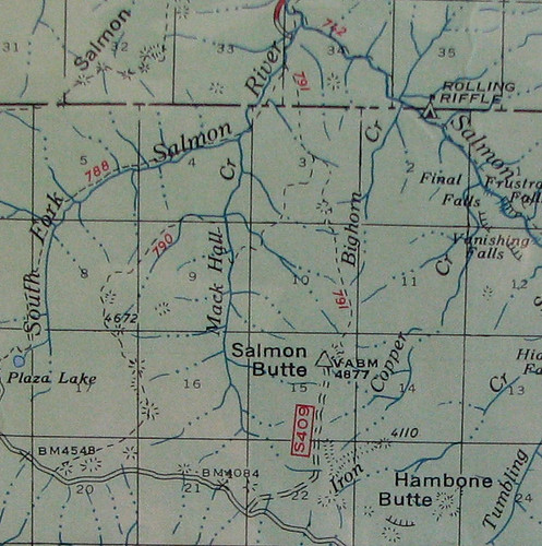
So with plenty of historical support, it looked like there might be something there.

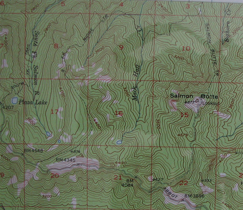
The approach was to do Salmon Butte to Abbot Road then west to the start of the trail off Abbot and then follow the 1956 version of the trail to intersect with Salmon Butte trail and out.

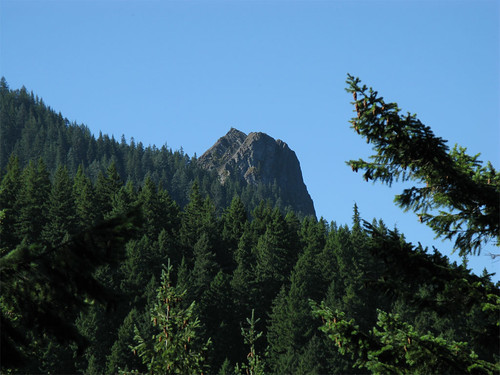
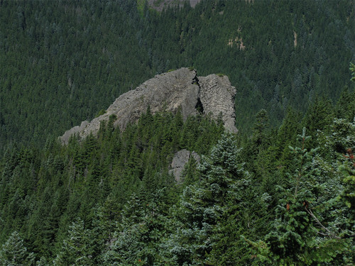
I departed the Salmon Butte trail head around 8:30. On the Salmon Butte trail early on you get a glimpse of the huge rock outcropping that lies just west of the summit of Salmon Butte.

Image

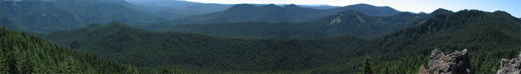
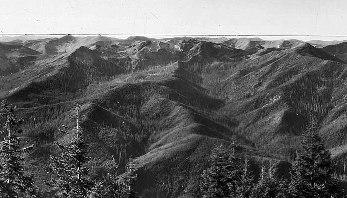
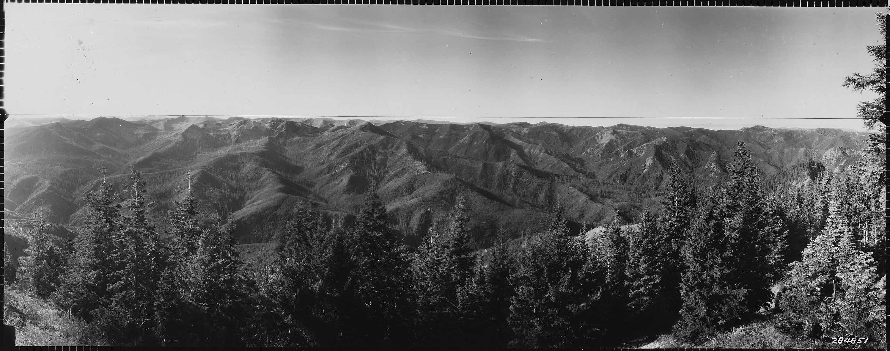
While the views from Salmon Butte are quite beautiful, my interest was in the scout for another hike I'd like to do, the Hambone Trail. Here is a panorama of the ridge line the Hambone Trail runs on. Actually, the Hambone Trail runs up the ridge just to the west of the ridge Hambone Butte is on, the trail obviously named for the destination. If you follow the near ridge from right to left, you'll encounter a small dip in the ridgeline. It is there the trail enters the ridge after leaving the saddle and traversing the bowl from Hambone Butte. Just a nice long, even ridge hike until dipping into the Salmon River.

Image

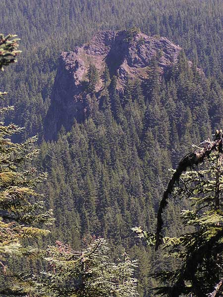
Another shot of the massive rock outcropping from a little south of the Salmon Butte summit.

Image

Once on Abbot Road, I came on the infamous washout, it starts with The Big Dip and the logs across the road feature.

Image

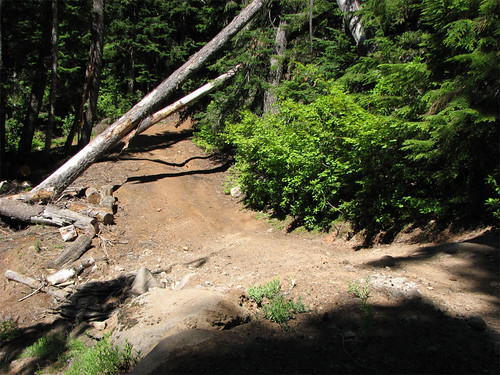
Further west on the way out of The Big Dip, the Steepness guards the west entrance, guaranteed to take the bottom out of your Honda Accord - my KLR-650 looks like the appropriate vehicle for negotiating this part of the road:

Image

I went along Abbot until due south of the South Fork Ridge where I bushwhacked up the hill to a viewpoint and the start of the ridge. This was not the start of the trail proper but I was running late. The trail proper according to the 1956 map starts further west and goes east along the side of the hill to meet the ridge.

Once on the ridge, the going was fairly easy with lots of flowering rhododendron but not the dense thickets that drove me off Salmon Mountain last year. The forest is quite young with a thick canopy that keeps the underbrush down, likely recovered from a burn 30-40 years ago. I saw no blaze the entire day given the age of the trees on the ridge, not surprising.

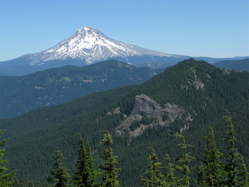
Further down the ridge a very nice viewpoint presented itself and from there details about the rock outcropping on the side of Salmon Butte became apparent. I claim it is the neck of an old volcano. Looks very climbable on that sloping part on the right.

Image

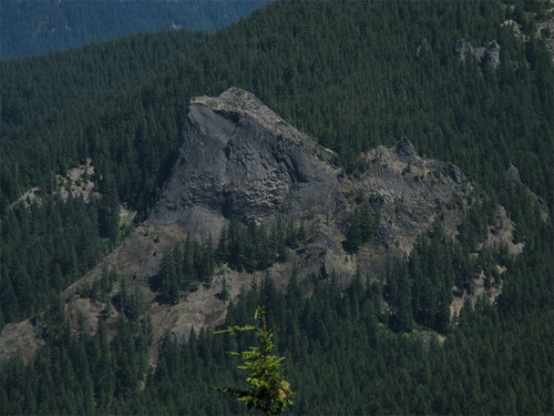
Here's a wider shot of the rock, Salmon Butte and Mount Hood in the background.

Image

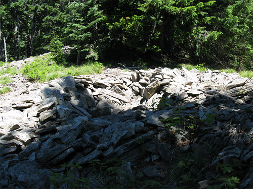
Came across a fire ring from several years back, some rock cairns here and there, and a sawed tree so people still travel this ridge. No sign of an obvious trail the entire day. A possible vision quest pit on the ridge:

Image

The ridge was pretty easy except for one extremely steep pitch, 40-50%, down to a talus slope - this traverse is part of the trail on 1956 USGS map, I stayed on the ridge line too long so I had to get there via a steeper route. I think the purpose of the talus traverse was to route around some rocky bits on the ridgeline but I did not explore that part.

After some tricky navigating and heading off down the wrong ridge, I dropped into the canyon formed by a tributary of Mack Hall Creek. Things got tough in here with larger trees, some old growth, and lots of downed stems to climb over. The rest of the hike was pretty much on the side of the hill and the constant need to dig into the side of the hill with the edge of my boots took its toll on muscles not generally used. It was warm and dehydration along with leg cramps started to kick in so I downed my 32 ounce bottle of Pediolyte which seemed to help. I crossed Mack Hall Creek and recharged my water supply and continued along the contour that would return me to the Salmon Butte Trail. I tell ya, the last .25 mile to the SB Trail seemed like 20.

Were I to do this again, and I might, I'd follow the ridge all the way down to the confluence of the South Fork of the Salmon and Mack Hall Creek then use the route along the abandoned S. Fork Salmon River Trail to connect to the road back to the Salmon Butte Trailhead. The side hill stuff with all the creeks was brutal. I exited totally exhausted, in retrospect doing Salmon Butte was probably tough enough and took away the energy I needed to finish in better shape than I did. If I do Hambone, I'm going to start from Abbot Road at Hambone Springs or maybe park at the upper Salmon Butte trailhead and return on Salmon Butte - it would be painful but at least I would not have the added pressure of route finding.

13.5 miles, 4800' cumulative, about 11 hours.

Image
The future's uncertain and the end is always near.

User avatar
Splintercat
Posts: 8333
Joined: May 28th, 2008, 10:03 pm
Location: Portland
Contact:

Re: #790 South Fork Ridge Trail Recon - July 31, 2008

Post by Splintercat » August 1st, 2008, 10:08 pm

Great report, Paul! Very interesting that you found signs of human visitors along the ridge top. I've heard from a couple of old timers that these trails did exist, and that a remnants of a trail that predated Abbot Road still exist, along the ridge top above the road. I have never found any traces of that trail, nor a map indicating it. Plus, old photos from 1933 show Abbot Road in place, so a long time has passed since that trail was used.

Here's a photo from that vintage that I've posted a preview up, plus uploaded in original dimensions so that you can scroll a bit -- it's the entire south slope of the Salmon River area, as viewed from the Devils Peak Lookout in 1933:

Image

Here's the original image

As you can attest to from your own bushwhacking, there are pockets of old growth in a few drainages, but the terrain was largely cleared by fire, and very rugged! Thought this might cast some light on your thinking about the original trails.

You've also touched on a pet fascination, and that is monoliths! There are many of these, of course, and I would definitely agree that you're looking at volcanic plugs in almost every case in the Oregon Cascades. Some have names - Sheepshead Rock along the Plaza Trail, Sunshine Rock, below Indian Mountain - and others are pretty much unexplored and unnamed. I LOVE the view of the Salmon Butte monolith from your bushwhack - this is one that I call the "Salmon Fin" (and you know my penchant for attaching names) for obvious reasons, but your view brings an even more "fin-like" shape to the rock! That's very cool.

There is another big monolith in the Salmon-Huck area that I call the "Devils Tooth", also a derivative of the main peak, nearby. This one is just east of Devils Peak - here's what it looks like from the trail:

Image

This one also appears to be scalable, albeit with a gnarly 350-foot sheer face dropping off to the north!

Paul, if you do go in search of the Hambone Trail, be sure to throw in a side trip to Hideaway Falls. So far as I know, it hasn't been visited since being named in 1963. I've got a photo that purports to be the falls, but it could easily be in error. That's one rugged canyon down there, too!

Thanks for the excellent report, as usual! :)

Tom

User avatar
mattisnotfrench
Posts: 1318
Joined: May 28th, 2008, 10:03 pm
Location: SE Portland
Contact:

Re: #790 South Fork Ridge Trail Recon - July 31, 2008

Post by mattisnotfrench » August 2nd, 2008, 9:43 am

Is the South Fork Salmon River still hikeable? I love that area!
Author of Extraordinary Oregon!, PDX Hiking 365, 101 Hikes in the Majestic Mount Jefferson Region, and Off the Beaten Trail. Website: www.offthebeatentrailpdx.com

pablo
Posts: 1451
Joined: May 28th, 2008, 10:03 pm

Re: #790 South Fork Ridge Trail Recon - July 31, 2008

Post by pablo » August 2nd, 2008, 10:03 am

Tom,

Thanks for the pointer to the lookout photo, those ridge lines look pretty bare vegetation-wise, I expect to see on the Hambone route much of what I saw on the S. Fork ridge.

The shape of the monolith on Salmon Butte was a pleasant surprise.

My expectations for trail finding are a little higher for Hambone as it appears on the 1972 USGS TOPO coming out of the Salmon River - not that I consider that much of a recommendation. I expect no blaze on trees for Hambone on the ridge until lower down in the canyon where the trees appear to be more mature. Apart from the bowl under Hambone Butte, I don't see any viewpoint opportunities on Hambone so I guess this will be one of those "because it's there" explorations.

Hideaway Falls caught my attention but it looks to be too far off the Hambone route to be safely done in a day hike starting from Hambone Springs. Looking at the map in NG TOPO, an approach from the Salmon River trail might be easier.

I was wondering about the conditions of Abbot Road to the Hambone camp site and wouldn't you know it, the internet is a great place.

--Paul
The future's uncertain and the end is always near.

pablo
Posts: 1451
Joined: May 28th, 2008, 10:03 pm

Re: #790 South Fork Ridge Trail Recon - July 31, 2008

Post by pablo » August 2nd, 2008, 10:08 am

mattisnotfrench wrote:Is the South Fork Salmon River still hikeable? I love that area!
Some fool did this last year and posted a trip report. He left out the part about burying his foot in a yellow jackets nest and getting stung 7-8 times by some really really irritated yellow jackets. The rhododendron branch poke in the eye co-pay on the doctor bill ran about $500. It was interesting and memorable but I'm not sure I'd ever want to do it again.

South Fork Salmon River to Plaza Lake - Sept 11, 2007

--Paul
The future's uncertain and the end is always near.

User avatar
Splintercat
Posts: 8333
Joined: May 28th, 2008, 10:03 pm
Location: Portland
Contact:

Re: #790 South Fork Ridge Trail Recon - July 31, 2008

Post by Splintercat » August 2nd, 2008, 1:55 pm

Ouch... some painful details there, Paul..!

Say, I think the Vanogan blogger was a bit harsh on the Abbot Road from High Rock to Hambone Spring. I've been on that fairly recently on bike and in a smaller SUV, and it's fine. Beyond that is another story, of course. The last time I was able to reasonably drive the entire road (w/four wheel drive and high clearance) was in 1993, but I'm delighted to see it falling apart. This is one road that I'd like to see decomissioned -- from Twin Springs to High Rock would be about right.

Paul, I know you've seen the Clackamas Trail Advocates info on the Hambone area, but there was a guy posting there a couple of years ago who had explored the Iron/Copper/Tumbling creek basins pretty extensively. Might be worth a post to see if he's still around.

-Tom

User avatar
Don Nelsen
Posts: 4380
Joined: May 28th, 2008, 10:03 pm
Location: Vancouver, WA

Re: #790 South Fork Ridge Trail Recon - July 31, 2008

Post by Don Nelsen » August 2nd, 2008, 3:52 pm

Hey Pablo,

Nice work, well documented and great photos! Thanks for a great read.

Don
"Everything works in the planning stage" - Kelly

"If you don't do it this year, you will be one year older when you do" - Warren Miller

User avatar
jaimito
Posts: 850
Joined: May 28th, 2008, 10:03 pm
Location: Kenton
Contact:

Re: #790 South Fork Ridge Trail Recon - July 31, 2008

Post by jaimito » August 4th, 2008, 10:07 pm

Don this is one I think we need to go check out… What do you think?


JC

Post Reply