Day Three, July 27. The Quest for Lost Trail 1935.
The next morning we leisurely enjoyed our coffee and it wasn’t until the day had warmed that we set out to search for trail 1935. From the previous day’s sleuthing we knew not to cross the little creek and from the map we knew the creek lead to a cirque, from which the trail followed a side drainage East.
The terrain proved to be rock outcrops interspersed with boggy, marshy meadow, heavily frequented by elk. Shortly we reached the cirque, found the obvious east trending drainage, and immediately found a trail.
 Viewed 3720 times")
- Picking up the Trail.
This we followed past a small pond, a long lineal meadow, and a rocky slope above a north/south gully.
 Viewed 3720 times")
- The Long Meadow.
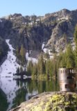
 Viewed 3720 times")
- Cached Lake (bottom left).
Here the trail turned left 90 degrees and ran up the hill a ways before turning 55 degrees or so left again, to follow another gently sloping ramp up.
 Viewed 3720 times")
- Left turn upslope--Departure Point for Needlepoint.
 Viewed 3720 times")
- Tread under Trees
This last segment brought us close to the low point of the ridge where we lost the trail—for in looking up at the ridge, we failed to notice that the very faint tread dropped below some clumps of trees and rocks.
No matter—we gained the ridge top, from which we could see the other side was snow covered.
 Viewed 3720 times")
- The Other Side.
Just to our right, however, the snow ended, and there was a trail tread heading down, although it, too, disappeared under the snow. Fearful that the snow might be too hard to kick steps in, we stayed on rock and made our way down to the long, arcing bench that goes all the way to Pop Lake. Looking back we could see a second trail tread coming off the ridge crest further west. Below this second crossing a clearly discernible trail resumed, which we followed to Pop Lake.
 Viewed 3720 times")
- Trail Crossing (Upper Left)
Now during all this we saw no human sign—no foot prints, candy bar wrappers, and such, unless you want to count a very rusty can of the size fruit cocktail used to come in.
 Viewed 3720 times")
- Can Cairn
So when we were 2/3rds of the way down to Pop Lake we were surprised to hear a voice from the ridge crest above us. And there was a guy up there, wearing a red pack, pushing rocks down a chute. The country between his location and the 1922 trail isn’t too difficult, but, nonetheless, rock roller guy was a long ways from any access.
 Viewed 3720 times")
- Rock Roller Guy
We followed the trail down to Pop Lake’s shore—a gorgeous, deep, blue-green lake circled with trees on three sides. On the west side, where the trail hits the lake, there is an “illegal” campsite with fire ring. (Illegal as in too close to the lake).
 Viewed 3720 times")
- The Lake
Susan set up to fish—caught a 9-10” brookie on her first cast. I, meanwhile, went around the lake’s north side, following the faint trail, which continued past the lake and down the outlet drainage. Not having the time to follow the trail, I climbed the knoll East of the lake. The knoll’s top is flat and has an improved campsite with a nice fire ring, a four person rock bench on one side, two rock settees, and a cook table with seat on the other. This campsite was fully legal, very large, level, but lacked shade. However, due to its knoll-top location, it is not visible from the trail or lake shore, so is stealthy if you are into stealth.
 Viewed 3720 times")
- Knoll Campsite
By the time I returned to Susan, she had caught 7 more fish. We snacked, packed up, and followed the trail back to the ridge crest, easy now that a refreshing breeze kept us cool. Up top, we kick stepped our way up the snow to the more westerly ridge crossing. On the other side we picked up the segment of trail we had missed when going the other way, successfully following it all the way back to the cirque.
Looking at the topo map and sat photos, it appears a route more east of the creek-to-the-cirque could avoid the marshy areas we encountered. I looked for any sign of such a route as we followed the trail down into the cirque, but, seeing none, we followed an elk path along the creek to the 1922 trail and back to camp.
Not only does trail 1935 exist, we were able to follow it 80% of the way from Cached Lake to Pop Lake. The segment where we could not find the tread was between Cached Lake and the cirque. According to a post by roninor several years ago, Trail 1935 was never maintained and was originally a sheep trail. We saw no signs of trail work or improvement except for one rock, which appeared to have been bored and blasted, and a couple shallow switchbacks—no water bars, no cuts on branches, no cut logs.
People? Rock Roller Guy plus two groups of three people who passed by our camp. The first group had come over Wonker Pass. The second group appeared in the brush below our camp and asked where the trail was. “Keep going” we said, “Its right in front of you.” Since we had not seen them on our Pop Lake adventure, we guessed they had done Needlepoint and were returning to a base camp below us.
To be continued.
I keep making protein shakes but they always turn out like margaritas.