McNeil Point Hike in snowshoes?
McNeil Point Hike in snowshoes?
Has anyone ever attempted getting to McNeil Point (at least till the shelter) in winter by going the usual route from Top Spur trailhead? Would it be unsafe in terms of route finding and anything else like avalanche conditions?
-
retired jerry

- Posts: 14424
- Joined: May 28th, 2008, 10:03 pm
Re: McNeil Point Hike in snowshoes?
it mostly follows along the top of a ridge so might have minimal avalanche risk
you might want to deviate from the trail a bit to avoid slopes that could avalanche, like right where the use trail leaves the Timberline Trail
the official trail traverses slopes as it gets towards the top but the unmarked use trail that goes straight up might be better
you might want to deviate from the trail a bit to avoid slopes that could avalanche, like right where the use trail leaves the Timberline Trail
the official trail traverses slopes as it gets towards the top but the unmarked use trail that goes straight up might be better
Re: McNeil Point Hike in snowshoes?
It sounds like a fun trip but I'm pretty sure the road will be gated closed miles before the trail head. See: https://www.fs.usda.gov/detail/mthood/a ... 108#Zigzag
Re: McNeil Point Hike in snowshoes?
Thanks. I was wondering about the roads. Your link does show though that the "Top Spur Trailhead Rd" isn't necessarily closed for winter, and this is what I thought usually you take to get to the start of the usual trail. Am I missing something?
-
retired jerry
- Posts: 14424
- Joined: May 28th, 2008, 10:03 pm
Re: McNeil Point Hike in snowshoes?
There's a (closed) gate at the Sandy River for the road that goes over to McNeil campground, Ramona Falls trailhead,...
I don't think there's any gate for the road to Top Spur trailhead. One year it was blocked with concrete blocks near Lolo Pass.
I don't think there's any gate for the road to Top Spur trailhead. One year it was blocked with concrete blocks near Lolo Pass.
-
adamschneider

- Posts: 3716
- Joined: May 28th, 2008, 10:02 pm
- Location: SE Portland
- Contact:
Re: McNeil Point Hike in snowshoes?
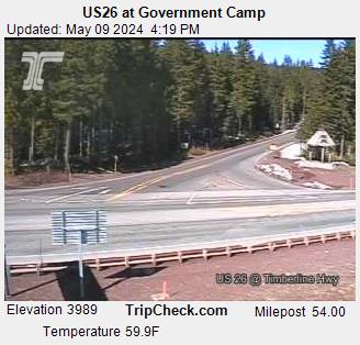
I don't think FR 1828 (nor 1828-118) is gated... but it definitely isn't plowed, and the trailhead is at about 4000', which is the same as Government Camp. So if you see snow on the ODOT cameras at G.C., there's probably snow at Top Spur.
-
OregonSurveyor

- Posts: 54
- Joined: August 6th, 2011, 11:21 am
- Location: SE Portland (Hawthorne district)
Re: McNeil Point Hike in snowshoes?
Several years ago I drove up the Rd1828 as far as I dare, then snowshoes up the road and trail and overnighted up there on the ridge below McNeil. The next morning I awoke to find fresh cougar tracks 20’ from my tent!
Look for a good weather forecast and go for it!
Look for a good weather forecast and go for it!
Jerry King
Oregon Land Surveyor (Retired)
SAR Volunteer - CSAR (Clackamas County Sheriff)
Oregon Land Surveyor (Retired)
SAR Volunteer - CSAR (Clackamas County Sheriff)
Re: McNeil Point Hike in snowshoes?
Yep, Adam. You are correct. I was mixed up in pointing to the roads table. I habitually consider that part of the road system closed in the winter due to the risk of me getting my car stuck in the snow.
Re: McNeil Point Hike in snowshoes?
Someone got to within 3 miles of the TH recently and then snowshoed in to Bald Mountain.
https://www.facebook.com/groups/Portlan ... SEARCH_BOX
If that doesn't work just search for "top spur" on the Portland Hikers FB page. Post was on 12/28 by Perez.
https://www.facebook.com/groups/Portlan ... SEARCH_BOX
If that doesn't work just search for "top spur" on the Portland Hikers FB page. Post was on 12/28 by Perez.
Re: McNeil Point Hike in snowshoes?
Despite the content of that Roads Table, the actual signage on Lolo Pass Road is roughly: Closed to vehicles over 50" wide when there is 12" or more of snow.johnspeth wrote: ↑December 29th, 2018, 9:42 amIt sounds like a fun trip but I'm pretty sure the road will be gated closed miles before the trail head. See: https://www.fs.usda.gov/detail/mthood/a ... 108#Zigzag