
Tom I can't believe you swam through that much PO, wow! I don't think I would have tried to push through it with anything less than a flamethrower!
Viento creek should be walkable if one simply goes up the stream, PO does not like the dampest places, so if you can stay glued to the stream bed I'm sure there is plenty to be explored up there. Nice trip!
Scouting Viento Creek & Viento Bluff
-
Splintercat

- Posts: 8334
- Joined: May 28th, 2008, 10:03 pm
- Location: Portland
- Contact:
Re: Scouting Viento Creek & Viento Bluff
Thanks, Mandrake - it says "Service Road Personnel Only", I think. There's also an RV parked next to the barn, plus some vehicles... so I was a bit reluctant to go boldly marching by... but now I must go! 
Andy, your Moffett experience was definitely in the back of my mind when I was pushing through the itchy stuff. As it turned out, I ended up doing the Wygant Trail on the same day (separate trip report), and while there was plenty of poison oak along the trail, at least there was a trail! So in comparison, it was not a problem..! However, when I go back to take Mandrake's route up the service road, I'll still need to return via the poison oak stretch, since my main goal is to scout it for trail purposes. I might need to wear hip-waders...
Andy, did you see the rubber boa that I photographed along the creek? Nearly stepped on it... and that freaked me out a bit. They're not dangerous, just BIG!
Tom

Re: Scouting Viento Creek & Viento Bluff
how long was it from where you parked to the waterworks??
Jamey Pyles
-
Splintercat
- Posts: 8334
- Joined: May 28th, 2008, 10:03 pm
- Location: Portland
- Contact:

Re: Scouting Viento Creek & Viento Bluff
Tom would the whole route be on State Park land? We're going down to Salem to meet with them in August. They might give some serious consideration to a project like this!
-
Don Nelsen

- Posts: 4382
- Joined: May 28th, 2008, 10:03 pm
- Location: Vancouver, WA
Re: Scouting Viento Creek & Viento Bluff
Hi Tom,
Just now found this post - nice job and great documentation of an area I have not much experience in. I've become very sensitive to PO and that area is one of the worst. Your photo of the "forest" of PO gives me the itchies just looking at it. Interesting artifact, too, but can't tell from the pic what it might be.
- Don
"Everything works in the planning stage" - Kelly
"If you don't do it this year, you will be one year older when you do" - Warren Miller
"If you don't do it this year, you will be one year older when you do" - Warren Miller
-
Splintercat
- Posts: 8334
- Joined: May 28th, 2008, 10:03 pm
- Location: Portland
- Contact:
Re: Scouting Viento Creek & Viento Bluff
Well, it looked to be a large metal enclosure, maybe 3 feet wide by six or eight feet long (and partly buried). Maybe an early cell phone from the 1980s... or possibly an older GPS unit..? 
Jeff, it is on State Park land, and so is the little path over at Mitchell Point. Both look to be "low hanging fruit" as possible projects, with less bureaucracy (state agency), existing (and abundant) trailhead parking without pass requirements, and very easy access from Portland. Viento has water and a restroom in proximity to the trailhead, and Mitchell has an outhouse - not sure about water.
I'll make one more trip to Viento to follow Mandrake's tip, and hit the summit from the east side. I want to get a good sense of just how sketchy the summit really is in terms of sending hikers (and especially kids) there. From below, it looks gentle and relatively spacious on top, along the lines of many other rounded basalt bluffs in the Gorge. Here's a detail shot of the top that I took last week:
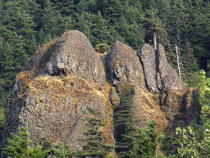
The summit is the larger block on the left. For scale, that's a manzanita growing at the top of the chute in the center of the view, and is probably 6-8 feet tall. Oregon State Parks likes to install cable fencing around spots like this, and that wouldn't bother me too much, either.
Another piece in the recon work that I'm doing is along this west bluff, located on the opposite side of Viento Creek from the main Viento Bluffs, and immediately above the Viento interchange:
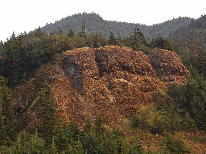
Like the main bluffs, this cliff section can be approached on a gentle slope from the rear. In this case, the powerline access road comes very close to the bluffs, but then veers away. This seemed like another possibility for a very short family hike using the road and a spur -- patterned after the Bridal Veil Bluffs. I think poison oak could pretty much be expected up there, so I'm saving the bushwhack on this one until after the leaves drop..!
-Tom
Jeff, it is on State Park land, and so is the little path over at Mitchell Point. Both look to be "low hanging fruit" as possible projects, with less bureaucracy (state agency), existing (and abundant) trailhead parking without pass requirements, and very easy access from Portland. Viento has water and a restroom in proximity to the trailhead, and Mitchell has an outhouse - not sure about water.
I'll make one more trip to Viento to follow Mandrake's tip, and hit the summit from the east side. I want to get a good sense of just how sketchy the summit really is in terms of sending hikers (and especially kids) there. From below, it looks gentle and relatively spacious on top, along the lines of many other rounded basalt bluffs in the Gorge. Here's a detail shot of the top that I took last week:
The summit is the larger block on the left. For scale, that's a manzanita growing at the top of the chute in the center of the view, and is probably 6-8 feet tall. Oregon State Parks likes to install cable fencing around spots like this, and that wouldn't bother me too much, either.
Another piece in the recon work that I'm doing is along this west bluff, located on the opposite side of Viento Creek from the main Viento Bluffs, and immediately above the Viento interchange:
Like the main bluffs, this cliff section can be approached on a gentle slope from the rear. In this case, the powerline access road comes very close to the bluffs, but then veers away. This seemed like another possibility for a very short family hike using the road and a spur -- patterned after the Bridal Veil Bluffs. I think poison oak could pretty much be expected up there, so I'm saving the bushwhack on this one until after the leaves drop..!
-Tom