In July 2011, I tried tracing the old Cascade Crest Trail (CCT) from its southern terminus (now the Dog Mtn TH parking lot) to the N side of Augspurger Mtn (CCT 2011). I found parts of it N and W of Augspurger but the part around the E side of Dog Mtn proved elusive – partly because of the thick summer vegetation. I made a note to give it a try again in winter – when the leaves are off – and yesterday was that day. It was foggy (apparently all day) in Portland but clearing and sunny – almost warm with no wind – at the Dog Mtn TH parking lot.
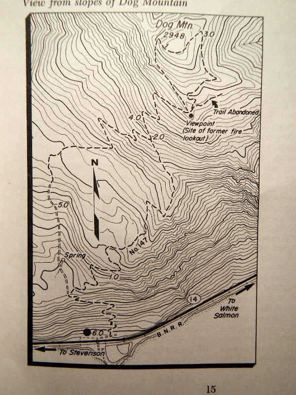
Before heading for the TH I’d done a little homework – but not quite enough as it turned out – about this section of the CCT and the Dog Mtn trail. At some point in the distant past, a logging road was bulldozed into the basin SW of Dog Mtn (you’re still walking on it today when you take the “direct” #147 trail to the summit). In the early 1930’s, this old road became part of a trail to a USFS lookout at Pt 2505. In 1933, the LO was scenic but spartan.
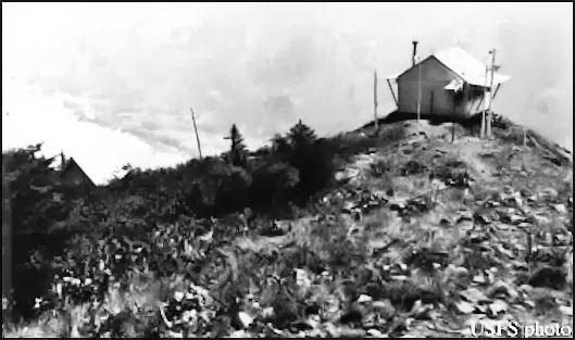
In 1935, the USFS completed an exhaustive reconnaissance of the CCT’s route and work began to piece it together from the Columbia River to the Canadian border. By 1953, the Dog Mtn LO had become a little wooden cabin
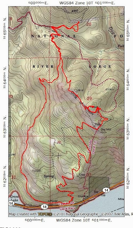
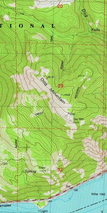
and the CCT extended N around the E side of Dog Mtn, as shown in this 1957 topo (part of the old logging road is also shown, as are the power line service roads N of Dog Mtn).
By 1962, the old CCT was as fully formed as it would ever be and even had its own guidebook.
That guide showed the CCT on the E side of Dog but said very little about the character of that segment of the trail.
The CCT had been part of the Pacific Crest Trail System since the 1930s but, with the passage of the National Trails System Act in 1968, movement began toward the fully integrated PCT we know today. The LO was removed in 1967. Spring and Manning’s 1971 guide to the South Cascades is one of the last to show the CCT and the Crest Trail Inn in what is now the TH parking lot (the Inn was managed by Glen and Mary Harrington from the late 40’s to the early 70’s).
Schaffer and Hartline’s 1976 PCT trail guide showed both the CCT and the new alignment of the PCT (some still under construction in 1976) but strongly recommended that hikers avoid the first 27 miles of the CCT, because “the trail, where it exists, is largely unmaintained and heavily vegetated…a likely bushwack…” Running the trail around the wetter, brushier E side of the mountain may partially explain why it became largely toast in only 10 years. The CCT (now called the PCT) still appears on this 1979 topo
and makes a brief appearance in the Lowe’s 1980 Columbia River Gorge hiking guide.
However, by that guide’s 1988 update, the trail is shown as abandoned,
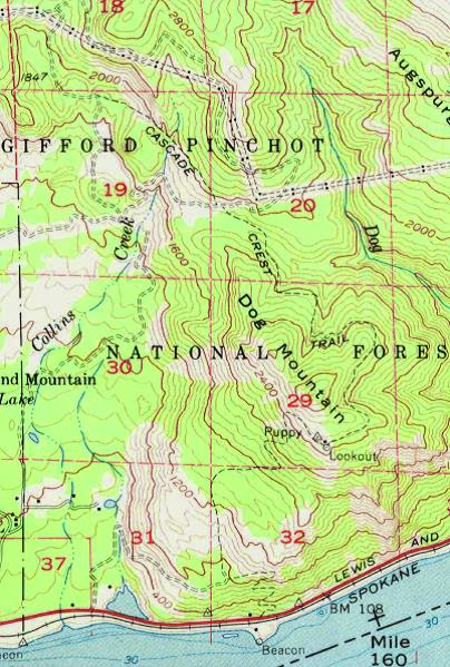
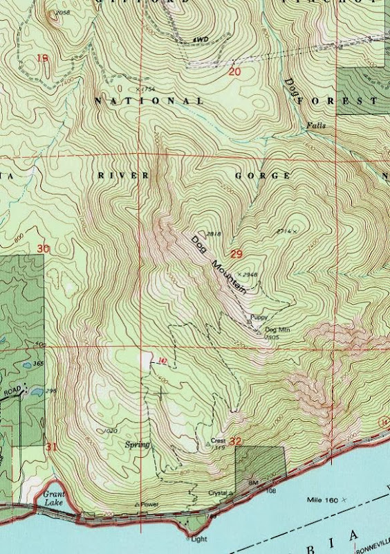
and is missing entirely from the 1994 topo.
Oddly, the power line service roads N of Dog – and which are still there today, despite the DNR’s efforts – are shown on the 1957 topo but are missing from the 1979 and 1994 topos. Then, mysteriously , the CCT/PCT comes back to life on the current National Geographic Topo! map for WA and on the Garmin map set– with an alignment that bears little to no relation to any previously mapped alignments, but is traceable to the ArcGISWorld map layer. Where that came from is unclear - but it's patently inaccurate.
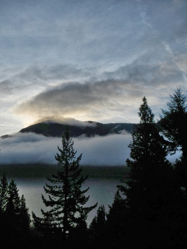
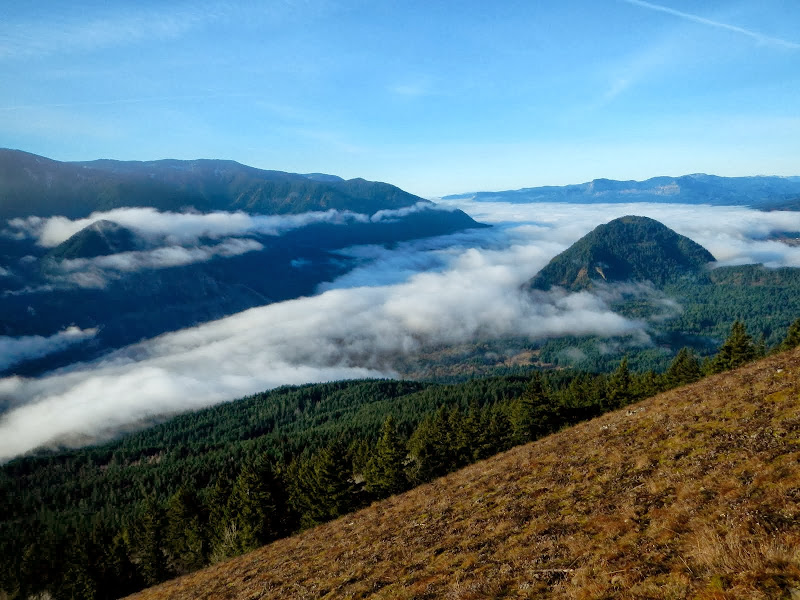
So, loaded down with history and a surprising amount of cartographic baggage for 4 miles of trail, I departed for the old LO site. It was a very nice day where I was, less so to the W.
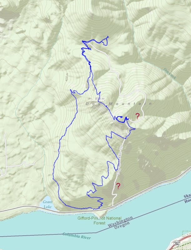
After reaching the old LO site, I looked for any sign of the old trail going to the E. Seeing nothing - which wasn't a surprise given that the trail was described as "over-vegetated" 40 years ago - I continued up the existing trail. This was a mistake because - in hindsight - the old trail didn't climb, but apparently contoured E at 2400' around Pt 2714. Had I thought this through, I might have been able to cut it by dropping down the ridge. But my attempts to make progress off the trail were sternly resisted by thick, springy, wet brush.
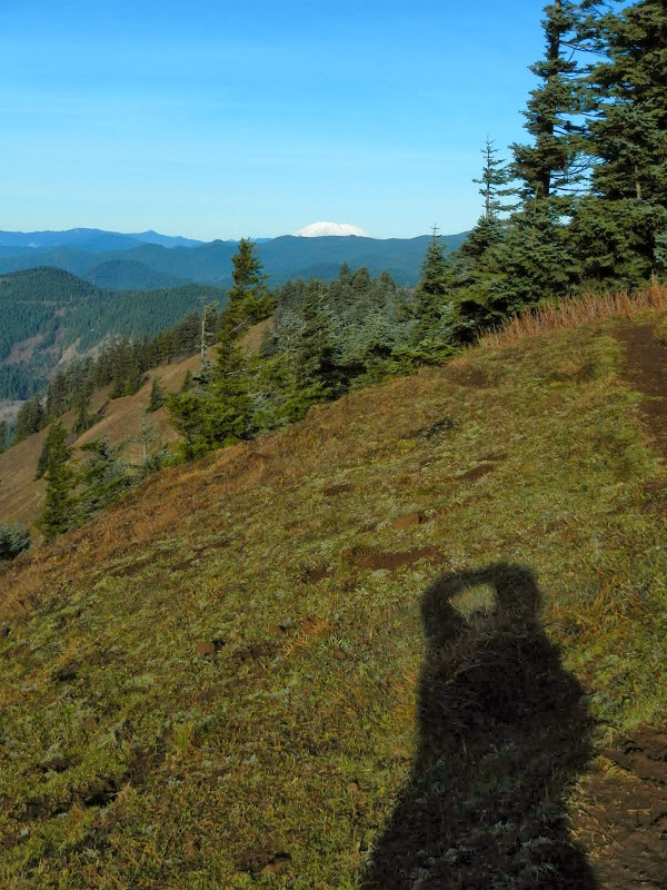
Once futility set in, I realized - as does every vet - that a dog has two ends and if I couldn't find the trail up here, I'd go poke around at the other end. So, I went up to the summit for a view of St. Helens,
then down the 147 and 4407 trails to where the old CCT was supposed to intersect the power line roads and where EP had earlier found a part of the CCT going N. Going SE, the trail had supposedly run along the intermittent tributary to Dog Creek before climbing up Dog. After a quick lunch, more uncomfortable crashing through wet, springy, thick, sharp brush ensued as I tried to work my way down the drainage looking for any sign of trail.
Again, futility happened, and I finally had to concede that this end of the dog was no more welcoming than the other and that this particular section of the CCT may have passed into history (which is not the case further N in Indian Heaven (Indian Heaven CCT)). So, chastened by cartography, I called it a day and took the Augspurger Trail (4407) back to the TH.
Time spent in the brush aside, it was a good hike (10.5 mi RT; 3,400' EG) on a (of course) bluebird day in the Gorge. I have one last idea for finding even a trace of this piece of the old CCT but it would probably take the considerable bushwacking skills of either Don or Pablo to actually follow whatever remains of it.
Walking the Dog: A Search for the CCT 18-Dec-2013
Last edited by VanMarmot on August 17th, 2015, 1:41 pm, edited 2 times in total.
- Don Nelsen
- Posts: 4380
- Joined: May 28th, 2008, 10:03 pm
- Location: Vancouver, WA
Re: Walking the Dog: A Search for the CCT
Bruce,
Thanks for a marvelous post and some great research! I really need to spend some more time up there and you give me some really good incentive to do so.
"Everything works in the planning stage" - Kelly
"If you don't do it this year, you will be one year older when you do" - Warren Miller
Re: Walking the Dog: A Search for the CCT
Great report, photos and an impressive amount of research. I like the Lowe maps, I trust their trail markings more than FS or USGS. On my visit to Dog's east ridge I ran across what looked like trail bench while I was going towards Puppy - not where I expected it but now that you posted those Lowe maps it might have been in there. I think the approach I'd try is that ridge going northeast from the summit - if there is anything left at all you'd have to run into it on the way down.
Worth a a couple more looks I say.
Thx,
--Paul
Worth a a couple more looks I say.
Thx,
--Paul
The future's uncertain and the end is always near.
Re: Walking the Dog: A Search for the CCT
Great report, Van... have been curious about the CCT alignment on the backside of Dog -- and what, if anything, is still left. I definitely would echo Pablo's comment -- that northeastern ridge seems to hold the most promise... trails often get obliterated in steeper drainages.
Re: Walking the Dog: A Search for the CCT
Not to throw gas on your fire or anything, but…
Last spring I went up Dog Spine with a group and after we topped out and put the gear away I got bored and started looking for antlers, mushrooms, bigfoot- there is always something interesting to find in the woods. Meanwhile my group abandoned me, heading one way or the other to find the trail and probably walking man pub. I figured I was 100 to 150' directly below puppy point but not wanting to ruin my wilderness experience with popping out on the trail and having 500 flip flop wearing tourists asking me if I'm lost and in need of directions. So I decided to head down and west figuring I will at some point cut the trail. About half way I hit what I assumed was a real good deer trail going basically the way I wanted to go. After a while it hit me as weird that the deer trail was so long and straight in a type area that animals wander and a good tracks is generally not more than 50' or so long. I popped out close to that last east pointing switchback about where the map shows the old trail to be.
Re: Walking the Dog: A Search for the CCT
Interesting. Any chance you could do a sketch map of your route?viking wrote:Not to throw gas on your fire or anything, but…
Last spring I went up Dog Spine with a group and after we topped out and put the gear away I got bored and started looking for antlers, mushrooms, bigfoot- there is always something interesting to find in the woods. Meanwhile my group abandoned me, heading one way or the other to find the trail and probably walking man pub. I figured I was 100 to 150' directly below puppy point but not wanting to ruin my wilderness experience with popping out on the trail and having 500 flip flop wearing tourists asking me if I'm lost and in need of directions. So I decided to head down and west figuring I will at some point cut the trail. About half way I hit what I assumed was a real good deer trail going basically the way I wanted to go. After a while it hit me as weird that the deer trail was so long and straight in a type area that animals wander and a good tracks is generally not more than 50' or so long. I popped out close to that last east pointing switchback about where the map shows the old trail to be.
- Eric Peterson
- Posts: 4097
- Joined: May 11th, 2009, 5:39 am
- Location: Oregon
- Contact:
Re: Walking the Dog: A Search for the CCT
I also came across definite old trail bench in '12 when I visited the Elkhorn falls on Dog Creek - TR:
http://www.portlandhikers.org/forum/vie ... 10&t=12862
Happened across it bush whacking up to the back of Dog summit.
That old alignment is mentioned too many times and printed in a lot of different sources to never have
been there, so there should be some semblance of something left and maybe even some blazes...
Re: Walking the Dog: A Search for the CCT
Hey Eric,Eric Peterson wrote:I also came across definite old trail bench in '12 when I visited the Elkhorn falls on Dog Creek - TR:
http://www.portlandhikers.org/forum/vie ... 10&t=12862
Happened across it bush whacking up to the back of Dog summit.
That old alignment is mentioned too many times and printed in a lot of different sources to never have
been there, so there should be some semblance of something left and maybe even some blazes...
Somehow I missed this report - quite an adventure, looks like you found it - the route you took off Dog was just the thing to do.
--Paul
The future's uncertain and the end is always near.
Re: Walking the Dog: A Search for the CCT
Last year My friend Scott and I hiked on the CCT starting at Triangle Pass. We got about 1.5 miles S on a distinct trail. We found a few trees that had CCT markers on them so I expect that trail E and N of Dog would still have marks on them. From the end of the trail we followed roads to the Quarry as we wanted to hike N Augspurger. Recently Charlotte head who has hiked that area for over 45 years drove us to the Quarry close to Larson Lakes Next year we hope to drive in close to Larson Lakes and do some more exploring. Has anyone been able to drive in to the Lakes.
Re: Walking the Dog: A Search for the CCT
What a heroic bushwack! You may have ascended to the realms of Don and Pablo with this one! And, yes, by your track, I think you did cut the old CCT. Will have to check this out. Thanks!Eric Peterson wrote:I also came across definite old trail bench in '12 when I visited the Elkhorn falls on Dog Creek - TR:
http://www.portlandhikers.org/forum/vie ... 10&t=12862
Happened across it bush whacking up to the back of Dog summit.
That old alignment is mentioned too many times and printed in a lot of different sources to never have
been there, so there should be some semblance of something left and maybe even some blazes...