Eliot Creek Crossing on the Timberline Trail (detailed pics)

This forum is used to share your experiences out on the trails.
Post Reply
User avatar
renegadepilgrim
Posts: 585
Joined: October 15th, 2010, 8:11 pm
Contact:

Eliot Creek Crossing on the Timberline Trail (detailed pics)

Post by renegadepilgrim » August 28th, 2013, 4:46 pm

Just finished the Timberline Trail yesterday. Tried to take some detailed photos to share with ya'll planning on doing it. We did it clockwise, so we came up on this crossing on our third day on the trail.
Image
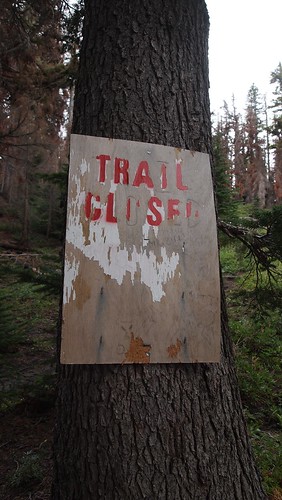
Trail Closed Sign by Renegade Pilgrim, on Flickr
Trail closed sign. Look to the right and you'll see a trail.

Image
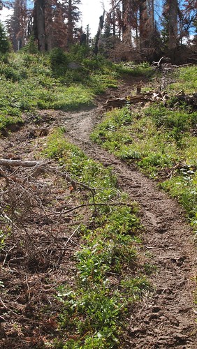
Follow this trail up the ridge line about 1/2 mile by Renegade Pilgrim, on Flickr
Trail heading straight up. You'll go up for a bit, past a flat area with campsites, then continue up, following the ridgeline.

Image
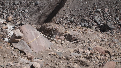
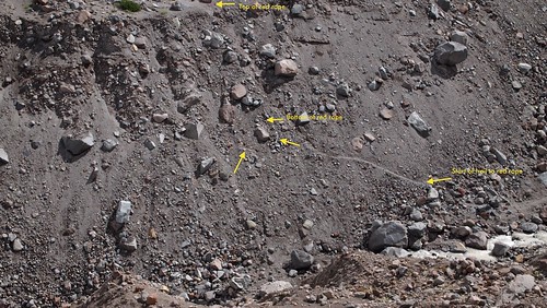
White rope looking down by Renegade Pilgrim, on Flickr
This is what the white rope looks like. It's about 30 feet or so from the top of the ridge.

Image
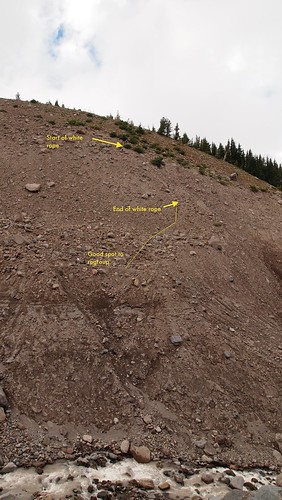
P8269534 by Renegade Pilgrim, on Flickr
Detailed look at the descent using the white rope.

Image
Looking down from end of white rope by Renegade Pilgrim, on Flickr
View from the end of the white rope...still have a ways to go to get to the bottom.

Image
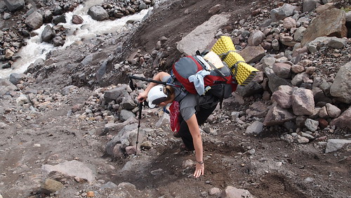
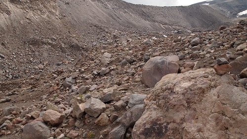
Scrambling down to Eliot Creek by Renegade Pilgrim, on Flickr
Scrambling to the bottom...there used to be a purple rope here but it has been mostly buried from another slide.

Image
Other side, using red rope by Renegade Pilgrim, on Flickr
How to find the red rope.

Image
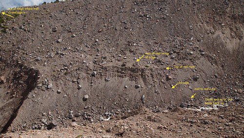
More detail on the other side, using red rope. by Renegade Pilgrim, on Flickr
Big picture look at the other side. Follow this trail up to the next "trail closed" sign, then follow ridgeline up to meet up with the Cooper Spur Shelter for a break before continuing along the Timberline Trail.

Trail report will be coming soon....challenging stream crossings were: Sandy River, Ladd, Coe Creek (running fast) and Eliot (not really but it could be). White River, Newton, and Clark were all fine...Newton even had a log "bridge" that was a welcome relief.
Travel and Outdoor Adventure Website: http://www.renegadepilgrim.com
Instagram/Tumblr/Twitter: renegadepilgrim

aircooled
Posts: 454
Joined: May 28th, 2008, 10:03 pm
Location: Portland, OR

Re: Eliot Creek Crossing on the Timberline Trail (detailed p

Post by aircooled » August 29th, 2013, 3:01 pm

Well done! The detail and instructions are much appreciated. This one is still on my list for this year.

User avatar
retired jerry
Posts: 14417
Joined: May 28th, 2008, 10:03 pm

Re: Eliot Creek Crossing on the Timberline Trail (detailed p

Post by retired jerry » August 29th, 2013, 3:07 pm

What I want to investigate, is that if you go upstream a few hundred yards, there's an easier route that requires no ropes

User avatar
renegadepilgrim
Posts: 585
Joined: October 15th, 2010, 8:11 pm
Contact:

Re: Eliot Creek Crossing on the Timberline Trail (detailed p

Post by renegadepilgrim » August 29th, 2013, 4:48 pm

Jerry, there is probably a way to do that if you go higher up the ridge to where it starts to cut down, and before you hit the glacier area...we could actually see it pretty clearly once we got across, but we took the well worn path instead...if you did go up that ridge and crossed, you could almost avoid the Eliot Creek crossing because it's a trickle further upstream. Then you'd have to climb back up on the ridge and resume your trek to get to the shelter. That's how Andrew at Next Adventure told me to do it...but since this path was pretty set, it seemed silly to attempt something higher up...although, it probably would have been a wee bit safer...but one never knows. If you check it out, take lots of pictures!!!! :)
Travel and Outdoor Adventure Website: http://www.renegadepilgrim.com
Instagram/Tumblr/Twitter: renegadepilgrim

User avatar
Peder
Posts: 3401
Joined: May 28th, 2008, 10:02 pm
Location: Lake Oswego

Re: Eliot Creek Crossing on the Timberline Trail (detailed p

Post by Peder » August 29th, 2013, 9:05 pm

My experience is that the easiest crossing is using the two ropes. For an easy and safe crossing of the Eliott Stream, you should go about 0.2 miles upstream from the ropes onto the next plateau; there the stream is divided into two branches and easy to cross. The terrain on the east side of the stream, between the rope and the easy crossing, is quite jumbled and off-trail experience is beneficial.

The upper crossing uses the Eliot Glacier access trail that is a little beyond the Cooper Spur shelter. We discussed that in detail last year.
Some people are really fit at eighty; thankfully I still have many years to get into shape…

User avatar
retired jerry
Posts: 14417
Joined: May 28th, 2008, 10:03 pm

Re: Eliot Creek Crossing on the Timberline Trail (detailed p

Post by retired jerry » August 29th, 2013, 9:16 pm

It's difficult to get up that slope on the Northwest side of Eliot of to the ridge overlooking Eliot. Steep and loose.

If you go 0.2 miles upstream from ropes, how do you get up to the ridge on the Northwest side of Eliot?

User avatar
Peder
Posts: 3401
Joined: May 28th, 2008, 10:02 pm
Location: Lake Oswego

Re: Eliot Creek Crossing on the Timberline Trail (detailed p

Post by Peder » August 29th, 2013, 10:08 pm

retired jerry wrote:It's difficult to get up that slope on the Northwest side of Eliot of to the ridge overlooking Eliot. Steep and loose.

If you go 0.2 miles upstream from ropes, how do you get up to the ridge on the Northwest side of Eliot?
Jerry - You go upstream from the ropes, cross the Eliot and then go back downstream to the second rope. Crossing the stream directly between the two ropes, as renegadepilgrim seemingly did, can be very adventurous! It is not for the faint of heart.
Some people are really fit at eighty; thankfully I still have many years to get into shape…

User avatar
renegadepilgrim
Posts: 585
Joined: October 15th, 2010, 8:11 pm
Contact:

Re: Eliot Creek Crossing on the Timberline Trail (detailed p

Post by renegadepilgrim » August 29th, 2013, 11:09 pm

Compared to the Coe Creek crossing earlier in the day (which was running fast and dangerous due to the rain the night before), Eliot was a cake walk...it was actually quite easy, and we went upstream a bit to cross as there were better options for us. :)
Travel and Outdoor Adventure Website: http://www.renegadepilgrim.com
Instagram/Tumblr/Twitter: renegadepilgrim

Post Reply