I was getting a little tired of the persistent dampness here, west of the Cascades, so on Friday I headed out east to take a look at the Swale Canyon portion of the Klickitat Rail Trail. It's about a two hour drive from the urban area, allowing for a pit stop along the way. The trailhead is desolate, but I was surprised to find I did have cellphone coverage there (although not at all along the trail itself). If you seek solitude, this is the place! Especially on a weekday. Not another soul encountered, until I reached the other end. More on that later.
Desperately Seeking Spring! I got a taste of it. But just a taste. These were the only clumps of grasswidows I saw all day.
I left the Harms Road trailhead, westbound into Swale Canyon, about 10:30am. It was brisk! The temperature was upper-30s, but the wind was persistent in the 20-25mph range as well. Long johns felt good, as the entire trail is just ever so slightly downhill - about 100'/mile - so there's no way to work up a good sweat. Be sure to bring wind protection (ears, hands, etc) out here! The trailhead is really just a wide spot in the gravel road (Harms Rd, clearly signed, 1/2 mile north of Centerville Hwy), with an outhouse.
Just pull over. Odds are, no one else will show up all day.
Dogs are supposed to be on leash, for both their own good (rattlesnakes) and the good of the other stressed out creatures (squirrels and marmots, mostly). Apparently, ticks are also an issue, but I didn't seem to pick up any along the way. They say it's "open range" country, and warn you not to harass the cattle or (in particular) their calves. I didn't actually see any livestock all day, though, so never got the chance. Ah well.
Snow covered Stacker Butte (3210') was a presence at the eastern end of the hike.
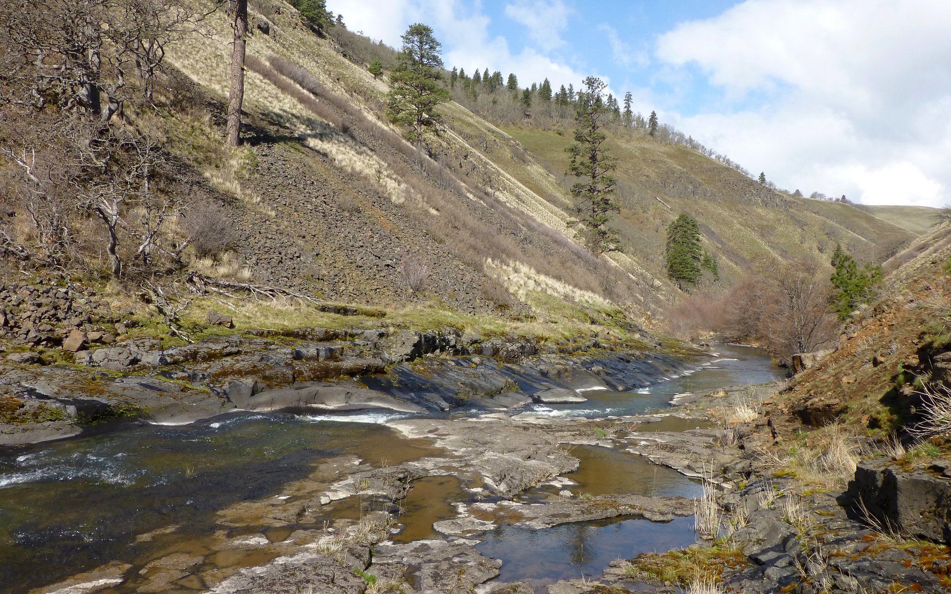
The "canyon" isn't really one at first, but it grows as you follow Swale Creek on it's course to the Klickitat. At the upper end, there were numerous mallards taking a break, and lots of robins. There are a few gates you'll encounter, which should be left in the same open/shut state you found them in.
One of several gates apparently meant to keep the cows from roaming too far astray.
It struck me as somewhat funny to see a Wildlife Area demarcated with barbed-wire.
Swale Creek isn't what you'd call a very vigorous stream.
Portions of Swale Creek were still frozen over as late as 11am.
Swale Creek seems to have a very high mineral content, leaving these white rings around many exposed rocks.
A couple miles in, I encountered a good sized marmot community. They mostly ran away from me. It was very different from hoary marmot encounters in more alpine environments. These guys seemed to be generally scared of people.
Within a couple miles of the trailhead, it did start feeling more like a canyon, and I encounter the first trestle of several. Some eccentricities started showing through, as well.
Stacker Butte is getting closer. Canyon walls "growing" as the river descends.
Interesting little shrine to a deer skull.
The volunteer trail-tenders have really done a nice job with the planking on several of the trestles. These are very easy to walk on.
Rail spikes are abundant, and people have gotten quite creative with them all along the trail.
A carefully balanced rock cairn, at just over 3 miles beside a waterfall, marks the major bend in the trail where it turns northward.
As the canyon deepens, the hillsides become more vegetated. Largely oak of a very scraggly nature, with smatterings of Ponderosa pine all around. Not much new green growth, at all, yet.
The canyon depth increases steadily as you proceed.
I really enjoyed these skeletal oak sculptures along many of the hillsides.
A few old mileage markers, presumably from the railroad days(?), dot the trail and nearly every trestle.
This weathered old scapula reminded me of a child's rendering of a big fish or whale.
The trestles deepest into the canyon haven't been retrofitted with planking to provide a safe walk/ride across. While they are mostly sound, there are definitely random ties that are very rotten and care must be taken.
Watch your step! There are some very rotten ties!
I decided to pocket the camera as I crossed these, taking it out only when stopped. Just felt better that way.
Yikes. This was my wake-up call. My foot sank right into it.
I found an ideal lunch spot alongside a trestle, on some nice smooth rocks beside the stream, about 8 miles in. The sun felt great by now, so I finally felt like taking off the long johns. Felt really good to get my feet out of the socks/boots too, and just let them stretch. That trail was making them scream! It was very, very rocky.
Lunched on those smooth rocks beside the creek. What a spot!
Things changed a bit, as I proceeded on after lunch. Of course, having lost a layer, it started snowing for a little bit. Heh. Then I came upon a real foretaste of what was to come. And it only got weirder as I continued.
Late-60s(?) Mercury Colony Park station wagon, license plate still intact up front.
Trailside fireplace. There was even a burnt out recliner one might have once relaxed in while enjoying the fire.
Another rig that someone seems to care about a bit more than the last. Just a bit.
Hmmmmmmmmm... (Listening for banjo, now!)
Then, the welcoming party greeted me to Appalachia with full vigor! Turned out, he was all wag, thankfully.
I crossed one last trestle, and decided it was probably time to head back. I was nearly 10 miles from the trailhead, and it was now about 2:45pm.
This one's clearly still being used by vehicles. Apparently some of them are actually functional!
The trip back up the canyon was uneventful. I enjoyed it much, as the sun had shifted and gave me entirely new perspectives on the landscapes I'd passed on the way in. I'll close with a few of my favorite shots of the return.
I remember this guy from previous TRs! Isn't he the work of one of us?
It was so enjoyable hiking in the pines again. Been awhile, and I always like them.
A great little lunch spot!
Solitary pine on a hillside.
The mineral deposits often provided interesting contrast in Swale Creek.
I think this might've been an elk, once. The bones sure seemed larger than a deer's might've been.
Red rocks, Ponderosa pine, and a mini-falls on Swale Creek.
Antique garbage.
Moonrise over a windswept grassy knoll.
Nice colors as the sun sinks lower and lower.
Marmot playground at other end of this beautiful trestle.
Just about out of the canyon, now.
A windfarm appears on the eastern horizon, signalling my trip is nearly over.
Recommendations I'd offer anyone who'd like to do this lovely trail... Wear your most comfortable shoes! The rocks made my feet want to scream! Letting them out of their confinement at lunch helped. I don't think I'd wear boots again on this trail. Also, bring wind protection! I had a hardshell in my pack, but a simple windbreaker would've been better. I was also glad to have had ear flaps, a hood, and gloves along.
There is cellphone service at the trailhead. But nothing once you're in the canyon. You will be totally alone out there, almost surely. I saw another human at the "encampment," but I wasn't all that sure what sort of help they might've offered had I been in need.
Altogether, I traveled a bit over 19 miles, with just 1000' EG. All the trestles are marked with photo pins on gpsfly, if you'd like to see where they are.
http://gpsfly.org/gps_map.php?gps_id=2233&w=645&h=440
If you're tired of winter wetness, this is a great escape from that!
Swale Canyon, 22-Mar-2013
Karl
Back on the trail, again...
- retired jerry
- Posts: 14418
- Joined: May 28th, 2008, 10:03 pm
Re: Swale Canyon, 22-Mar-2013
Too bad there's no camping
Re: Swale Canyon, 22-Mar-2013
wow! That looks like quite the adventurous hike. Your pictures tell a tale that is part Deschutes River-ish looking territory, part history, and part Deliverance movie. I'm not sure I'd want to do that one alone though.
- retired jerry
- Posts: 14418
- Joined: May 28th, 2008, 10:03 pm
Re: Swale Canyon, 22-Mar-2013
"I'm not sure I'd want to do that one alone though"
Deliverance - 4 men - how did that work for them?
- Splintercat
- Posts: 8333
- Joined: May 28th, 2008, 10:03 pm
- Location: Portland
- Contact:
Re: Swale Canyon, 22-Mar-2013
Just take your crossbow, Jim - you'll be fine...
Nice report, Karl! Great photos -- I especially liked the snowcapped views of Stacker Butte! Reminded me of being in Nevada in winter. It's truly amazing that we can be in a completely different climate regime in two hours..!
The sketchy trailer camp is a bit unnerving, but sounds like it was toward the lower end of the canyon, is that right? Private land along the trail, apparently.
Tom
-
- Posts: 2
- Joined: March 25th, 2013, 7:22 pm
Re: Swale Canyon, 22-Mar-2013
That is a great report. I have not hiked that stretch but I am so happy to see someone reporting on Klickitat County. Indeed when it is gray in Portland it is almost always sunny out there. The open dry terrain is such a neat contrast to the west side of the Cascades. Stacker Butte, HorseTheif Butte, Dalles Mt Road, Swale Canyon, Badger Gulch, Bickleton. I just wander and am amazed at the geology and lonesome old west experience.
Re: Swale Canyon, 22-Mar-2013
Same thought hit me a couple times. But it's almost like MSH, in that they really warn you to stay on trail due to private property issues. (I think portions of the trail are just easements?)retired jerry wrote:Too bad there's no camping
That one segment was a bit sketchy, yeah. I think partly because I had absolutely no expectation of encountering something like that out there. Felt others ought to know, particularly solo folks.Crusak wrote:wow! That looks like quite the adventurous hike. Your pictures tell a tale that is part Deschutes River-ish looking territory, part history, and part Deliverance movie. I'm not sure I'd want to do that one alone though.
Otherwise, yeah, the scenery was just terrific! Felt great to walk on dry ground again. To sit on a rock, without getting a wet butt. All that good stuff.
Thanks, Tom! Even more amazing, I felt that I was walking back out of the rain shadow in just those few short miles! There is a distinct change in vegetation just along this trail, with hardly a single tree at the east end, and rather more vigorous growth on the west end.Splintercat wrote:Nice report, Karl! Great photos -- I especially liked the snowcapped views of Stacker Butte! Reminded me of being in Nevada in winter. It's truly amazing that we can be in a completely different climate regime in two hours..!
It was at the northernmost end of my track, yeah. I suppose it's about 2.5 miles from the northwestern Wahkiacus trailhead. I was surprised I hadn't heard about it in other reports I'd read before going. What's really baffling is that they seem to have vehicle access along the trail. That last trestle I crossed right before turning around had clearly been driven over repeatedly.Splintercat wrote:The sketchy trailer camp is a bit unnerving, but sounds like it was toward the lower end of the canyon, is that right? Private land along the trail, apparently.
Just those names alone, conjure up all sorts of vivid images! It's an alien environment to a western valley dweller. Definitely worth the drive, when you feel compelled to escape the dampness.HomeValleyGirl wrote:That is a great report. I have not hiked that stretch but I am so happy to see someone reporting on Klickitat County. Indeed when it is gray in Portland it is almost always sunny out there. The open dry terrain is such a neat contrast to the west side of the Cascades. Stacker Butte, HorseTheif Butte, Dalles Mt Road, Swale Canyon, Badger Gulch, Bickleton. I just wander and am amazed at the geology and lonesome old west experience.
Thanks...
Karl
Back on the trail, again...
Re: Swale Canyon, 22-Mar-2013
Residents who live alongside the trail were not exactly thrilled when the trail went in and there were some early confrontations years ago. But that settled down long ago and whatever it looks like, there have been no problems in a long time. As with many long rails-to-trails, it passes through wild spots and not so wild spots. Most of Swale Canyon is pretty wild, but I also like some of the lower sections, like that above Fisher Hill Bridge, because it is right next to a sizable river. There is one place near Pitt where the Klickitat Trail goes through an old abandoned apple orchard. That's nice in the fall when you can pick your snack.
Re: Swale Canyon, 22-Mar-2013
Yeah, I'd heard about some of that "friction" early on. I just had images in my mind of that being with people living in those nice ranch spreads high above. Didn't know about the less permanent abodes closer in.drm wrote:Residents who live alongside the trail were not exactly thrilled when the trail went in and there were some early confrontations years ago. But that settled down long ago and whatever it looks like, there have been no problems in a long time. As with many long rails-to-trails, it passes through wild spots and not so wild spots. Most of Swale Canyon is pretty wild, but I also like some of the lower sections, like that above Fisher Hill Bridge, because it is right next to a sizable river. There is one place near Pitt where the Klickitat Trail goes through an old abandoned apple orchard. That's nice in the fall when you can pick your snack.
I think my next trip out there, I'd like to find a way to park in Lyle, and snag a ride up to Klickitat. That looked like a really nice route, as well! I have a map saying there's a trestle out over the river above Klickitat - do you know if there's an alternate way across?
Thanks!
Karl
Back on the trail, again...