Palmer Mill - Devils Rest Loop - 01/27/13

This forum is used to share your experiences out on the trails.
User avatar
Guy
Posts: 3333
Joined: May 10th, 2009, 4:42 pm
Location: The Foothills of Mt Hood
Contact:

Palmer Mill - Devils Rest Loop - 01/27/13

Post by Guy » January 27th, 2013, 5:37 pm

After reading Van Marmots great report of 01/19/13 about the system of old roads West of Devils Rest we set out today to explore some of them for ourselves.

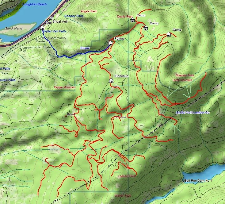
We parked at the Angels Rest trailhead & set off up the Palmer Mill Road.

Image

It's 2 miles up the road to the gate & the junction with Brower Road.

Image Image
Bridal Veil Creek at the Brower Rd. Palmer Mill Rd. Junction.

The position of the Palmer Mill road on some of the maps I looked at is incorrect here, the road that is shown on the map cutting off the long switchback seen in the map below isn't there! you have to hike up Palmer Mill a ways until you see the first gated road on your left. This road then doubles back & you can look down on the Palmer Mill road below.

Image Image

We soon came upon the first of many Archaeological sites ;)

Image
So I'd love to know what this setup was for!

In Van Marmots thread Pablo wrote about somebody blocking the creek with rocks forcing the water to run down the road instead. Pablo mentions removing the rocks to fix the problem but somebody for some reason had dammed it up again!

Image

Causing this:

Image Image

Not long after the creek crossing you find the Motorbikes!

Image


& then the vacuum cleaner :) ...

Image

The road we had followed from Palmer Mill came to an end shortly after the Vacuum Cleaner in the Alder Clearing (I've called Alder Junction on the map below). Another road enters the same clearing from the other side & this is the road we left on.

One curious trail junction we came accross (labeled Trail? J2) on the map, a well flagged trail heading uphill on our right side, not an old road. We didn't have time to see were it went today but it was well flagged & the only flagging we saw all day!

Image


We were getting up into the snow zone now!

Image Image

Image Image

A short time later we reached the junction with the trail up to Devils Rest & the exploring was done for the day. We decided to tag the summit since we were so close!

Image Image

Cold weather or not this little chap was still standing guard!

Image

After some hot tea we headed on down to Angels Rest & home!

Image

There where lots of people on the Angels Rest trail & it was very muddy in places.

There are a few side roads & that one flagged trail that we want to go back & check out, all told the loop came in at 10 miles & 2770' of EG!
A few more pics of day here. & here is a Map:

hiking log & photos.
Ad monte summa aut mors

User avatar
Eric Peterson
Posts: 4097
Joined: May 11th, 2009, 5:39 am
Location: Oregon
Contact:

Re: Palmer Mill - Devils Rest Loop.

Post by Eric Peterson » January 27th, 2013, 6:04 pm

J2 that heads towards Palmer Mill Road is a nice path, at least it was a few years ago
I ventured around back in there pre GPS. I went left at your junction since going right
was just FULL of viney stuff IIRC. Looks like you guys had fun! Julie and I almost
went over to the RJ over off Kueffler with my RJ map loaded into the GPS but
real life caught up to us and it was actually nice to get some things done around
the house and not look like milieageMike's twins in the housekeeping dept.!! :D
Last edited by Eric Peterson on January 27th, 2013, 6:07 pm, edited 1 time in total.

User avatar
Chase
Posts: 1265
Joined: May 28th, 2008, 10:03 pm

Re: Palmer Mill - Devils Rest Loop - 01/27/13

Post by Chase » January 27th, 2013, 6:05 pm

Nice work, Guy! I want to explore that area more in 2013.

User avatar
Guy
Posts: 3333
Joined: May 10th, 2009, 4:42 pm
Location: The Foothills of Mt Hood
Contact:

Re: Palmer Mill - Devils Rest Loop - 01/27/13

Post by Guy » January 27th, 2013, 6:13 pm

J2 that heads towards Palmer Mill Road is a nice path
Yeah Eric (Old Road - J2) goes back down to Palmer Mill Rd. but it's the next waypoint labeled (Trail? - J2) that's the mystery.

I'll send you my gpx then you can add this to Gorge Map + if you like. It's mostly on there now as 2 of DN's Explorer tracks but this ties them together.

Cheers.
hiking log & photos.
Ad monte summa aut mors

User avatar
Eric Peterson
Posts: 4097
Joined: May 11th, 2009, 5:39 am
Location: Oregon
Contact:

Re: Palmer Mill - Devils Rest Loop - 01/27/13

Post by Eric Peterson » January 27th, 2013, 6:15 pm

We will Chase, I worked up that 1913 Hood/Larch KML last night in fact, that has
the old RR grads and the Palmer/Donohoe locations as well :)

Check it out, this is from Basecamp, has the old 1913 USGS quad loaded under my
existing mapset -
1913_Larch.jpg
Was going to suggest sending ,e your track please to add it to the Gorge Mapset :)

User avatar
Eric Peterson
Posts: 4097
Joined: May 11th, 2009, 5:39 am
Location: Oregon
Contact:

Re: Palmer Mill - Devils Rest Loop - 01/27/13

Post by Eric Peterson » January 27th, 2013, 6:19 pm

Aah yes, I left the DN things in as rather incomplete actually removed a lot and will add some back in to
see how much of the RR grades he may have found or there are more in there to find. I'm guess if there
was a 1920's historical Topo there might be more logging RR's and flumes, will look and add if they
are readily exist. Somewhat planning a informal hike in this area as Chase expressed interest and I
said I would do my best to provide logistics when possible, plus it's fun trying to georeference these
old maps and make them navigable on my GPS...

User avatar
BrianEdwards
Posts: 2405
Joined: February 2nd, 2010, 1:32 am
Location: Oregon City, OR
Contact:

Re: Palmer Mill - Devils Rest Loop - 01/27/13

Post by BrianEdwards » January 27th, 2013, 6:30 pm

A major railfan/history buff on another site compiled what is to the best of his knowledge all the railroad grades on Larch. I was in contact with him during some of the compilation process. Here's his finished map. I don't think he has it on anything but a Jpeg.. :|

Image

I wonder how this compares to Don's findings..
Clackamas River Waterfall Project - 95 Documented, 18 to go.

User avatar
Eric Peterson
Posts: 4097
Joined: May 11th, 2009, 5:39 am
Location: Oregon
Contact:

Re: Palmer Mill - Devils Rest Loop - 01/27/13

Post by Eric Peterson » January 27th, 2013, 7:06 pm

Can the original get a bit bigger? Good to start off huge and we could georeference the map your friend made
so when it shrinks down into a small GPS reciever one wouldn't lose very much image quality.

However I could do something with this map as is...

User avatar
Chase
Posts: 1265
Joined: May 28th, 2008, 10:03 pm

Re: Palmer Mill - Devils Rest Loop - 01/27/13

Post by Chase » January 27th, 2013, 7:21 pm

BrianEdwards wrote:A major railfan/history buff on another site compiled what is to the best of his knowledge all the railroad grades on Larch. I was in contact with him during some of the compilation process. Here's his finished map. I don't think he has it on anything but a Jpeg.. :|

Image

I wonder how this compares to Don's findings..
Awesome map!

I believe one of the camps labeled "camp" is the Kelley Camp, though I dunno which one it is...

User avatar
BrianEdwards
Posts: 2405
Joined: February 2nd, 2010, 1:32 am
Location: Oregon City, OR
Contact:

Re: Palmer Mill - Devils Rest Loop - 01/27/13

Post by BrianEdwards » January 27th, 2013, 7:23 pm

Thanks Chase.

EP, I'll see what I can do when I get home Tuesday. Currently rocking just the iPhone in Brookings. I see your PM's are turned back on...
Clackamas River Waterfall Project - 95 Documented, 18 to go.

Post Reply