Some friends and I are headed to the Wallowas next week and I was hoping for some guesses/info on conditions and routes.
Does anybody know of any decent smoke forecast websites? Right now the webcams in Joseph look like it is fairly smoky out there. Our backup is the Trinities, which look less smoky today, but it seems like these things change quickly.
Back to the Wallowas, does anybody know where I can get info (description, map, or GPS track (the best!) for any of the following off-trail routes:
Ice Lake to Raz
Horesehoe Lake to Upper Raz
Pocket Lake
Prospect Lake
I have the Barnstad book but that's about it for beta. Thanks in advance!
Wallowas Help and Smoke Forecast
-
cunningkeith
- Posts: 209
- Joined: June 26th, 2010, 4:28 am
- Location: Portland
Re: Wallowas Help and Smoke Forecast
I've found some beta from borntobebrad on the route from Ice Lake to Upper Razz Lake...it looks doable, and I'm going to try that route mid September...I can send you the Caltopo route based on his info if you want.
Ian
Ian
-
Born2BBrad

- Posts: 1086
- Joined: May 1st, 2011, 7:26 pm
- Location: The Dalles
Re: Wallowas Help and Smoke Forecast
The trip I took did not involve making it to Razz Lake. The TR has a link to Bosterson's successful trip there. Below is a link to the TR and a link to the GPS tracks for that trip.
Have fun! Be safe!
https://www.oregonhikers.org/forum/view ... 5&p=184701
http://gpsfly.org/g/6227
Have fun! Be safe!
https://www.oregonhikers.org/forum/view ... 5&p=184701
http://gpsfly.org/g/6227
Make now always the most precious time. Now will never come again.
- Jean Luc Picard
Link to GPX tracks
Link to Trip Reports
- Jean Luc Picard
Link to GPX tracks
Link to Trip Reports
-
cunningkeith
- Posts: 209
- Joined: June 26th, 2010, 4:28 am
- Location: Portland
Re: Wallowas Help and Smoke Forecast
Thanks for the info. That's super helpful. It seems like the Ice Lake to Raz route is quite a bit tougher than just coming up from Horseshoe Lake. If anybody else has thoughts on this or the other lakes (Prospect or Pocket) please chime in.
I'm hoping the smoke situation improves so we can do this next week. There's a rumor that wind from the south is going to start blowing that will send the smoke back to BC. But if that happens, I'm wondering if the smoke from Jefferson will just fill into the Wallowas where the BC smoke left off. Does anybody have a smoky sixth sense out there and care to venture a guess?
Thanks again!
Re: Wallowas Help and Smoke Forecast
Keith-
I agree the route between Upper Razz and Ice looks challenging but milage wise short...my plan is to go up to Upper Razz from Horseshoe Lake and get eyes on the route before attempting. According to the beta, there is nothing technical about the route, but sound route finding skills will be essential. Thankfully it will fall at the end of my trip, so packs will be light
Good luck if you give it a go!
Ian
-
BurnsideBob

- Posts: 538
- Joined: May 6th, 2014, 3:15 pm
- Location: Mount Angel, Oregon
Re: Wallowas Help and Smoke Forecast
For smoke the following website gives a 48 hour forecast for OR, WA, ID, MT. You can zoom in to see how your intended destination is impacted. http://lar.wsu.edu/airpact/gmap/ap5/ap5smoke.html
For Razz Lake to Iceberg Lake you may find this trip report of slight interest: viewtopic.php?f=8&t=21901
While I didn't even get close, Bosterson gives some good beta in his response.
Good luck with your trip. Razz to Iceberg will be an accomplishment. The Barstad book not withstanding, I don't think many people have been successful on this route, which is why there is little info.
I keep making protein shakes but they always turn out like margaritas.
-
cunningkeith
- Posts: 209
- Joined: June 26th, 2010, 4:28 am
- Location: Portland
Re: Wallowas Help and Smoke Forecast
That's a really useful resource. Thank you!BurnsideBob wrote:For smoke the following website gives a 48 hour forecast for OR, WA, ID, MT. You can zoom in to see how your intended destination is impacted. http://lar.wsu.edu/airpact/gmap/ap5/ap5smoke.html

Re: Wallowas Help and Smoke Forecast
I just got back from Eagle Cap this evening. It's pretty smoky there. It's not bad enough to inhibit hiking, but the views are pretty hazy for things that are farther away. Still worth going to, and nothing else in the NW is probably much different (there was constant smoke on the entire drive between Portland and the Wallowas), but don't expect clear vistas. There's also still substantial snow on north facing aspects. Most south facing aspects have melted out, and some of the lower country is quite dry, though there are melt streams everywhere.
Re: your routes, I don't have a GPS track for my Razz route (though I hand-drew a little map that should be in my 2012 TR). It's fairly straight-forward: from Ice Lake, head up the gully between Craig and Razzberry mountains, then at the base of Razzberry (9314 ft, unnamed on the map but it's just west of Craig), climb across its north aspect across big talus blocks to a bench that leads to the ridge. Follow that to a notch and drop south over onto a slope that leads down to Razz. Over this past weekend there looked to be a little bit of snow in sections of the ridge (and it's a bit scrambly up there), but it might be doable. The entire south side of the ridge where the Razz lakes are is currently melted out. On the return in 2012, I went straight down the west slope from the notch, but this is a huge snowfield right now, so you'd either need an ice axe or you'd have to backtrack the ridge part of the scramble and then descend the forested slopes east under Razzberry. In the map below, the upper arrow is pointing at the notch you need to cross to get to Razz from Ice Lake.
Yesterday we came down the abandoned trail running from the Lakes Basin to the Razz Lakes, and while I didn't take a GPS along and can't give you exact coordinates, I think it's approximately at the lower arrow on the map below. Basically, after you pass Lily Lake on the upper trail, you'll pass some small granite outcroppings, and then in maybe 1/8 mile, keep an eye out on the left for a hidden trail heading uphill. (It's more visible about 20 feet uphill, as its junction with the maintained trail is faint.) If you come to the Razz outlet stream, you've gone too far (I'm pretty sure we ended up coming down on the west side of the stream, but the trail crosses it a couple of times). But you should be able to follow the outlet stream uphill as a backup plan, and if you're lucky, you'll happen across the trail, which is in good shape and sees some use. From the main (lower) Razz lake, you can follow its inlet stream uphill to the upper lake, which is above the treeline. Right now, going from the Lakes Basin is probably the better plan than going from Ice Lake, due to the snow on the north (Ice Lake) side of the ridge.
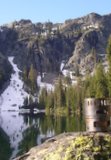
I found that I did take a pic over the weekend that shows the Razz notch from the Ice Lake side: the notch is at the top of the snowfield running up the middle of the photo below. My original approach crossed the top of the ridge to the left; however, if you have an ice axe, the snow was generally pretty soft, so you might be able to kick steps straight up the snow to the notch. Definitely be careful though, it's quite a long runout from the notch down to the talus below (walking down it in dry conditions was very tricky due to steepness and lack of purchase).
Re: your routes, I don't have a GPS track for my Razz route (though I hand-drew a little map that should be in my 2012 TR). It's fairly straight-forward: from Ice Lake, head up the gully between Craig and Razzberry mountains, then at the base of Razzberry (9314 ft, unnamed on the map but it's just west of Craig), climb across its north aspect across big talus blocks to a bench that leads to the ridge. Follow that to a notch and drop south over onto a slope that leads down to Razz. Over this past weekend there looked to be a little bit of snow in sections of the ridge (and it's a bit scrambly up there), but it might be doable. The entire south side of the ridge where the Razz lakes are is currently melted out. On the return in 2012, I went straight down the west slope from the notch, but this is a huge snowfield right now, so you'd either need an ice axe or you'd have to backtrack the ridge part of the scramble and then descend the forested slopes east under Razzberry. In the map below, the upper arrow is pointing at the notch you need to cross to get to Razz from Ice Lake.
Yesterday we came down the abandoned trail running from the Lakes Basin to the Razz Lakes, and while I didn't take a GPS along and can't give you exact coordinates, I think it's approximately at the lower arrow on the map below. Basically, after you pass Lily Lake on the upper trail, you'll pass some small granite outcroppings, and then in maybe 1/8 mile, keep an eye out on the left for a hidden trail heading uphill. (It's more visible about 20 feet uphill, as its junction with the maintained trail is faint.) If you come to the Razz outlet stream, you've gone too far (I'm pretty sure we ended up coming down on the west side of the stream, but the trail crosses it a couple of times). But you should be able to follow the outlet stream uphill as a backup plan, and if you're lucky, you'll happen across the trail, which is in good shape and sees some use. From the main (lower) Razz lake, you can follow its inlet stream uphill to the upper lake, which is above the treeline. Right now, going from the Lakes Basin is probably the better plan than going from Ice Lake, due to the snow on the north (Ice Lake) side of the ridge.
#pnw #bestlife #bitingflies #favoriteyellowcap #neverdispleased
-
cunningkeith
- Posts: 209
- Joined: June 26th, 2010, 4:28 am
- Location: Portland
Re: Wallowas Help and Smoke Forecast
Thanks Bosterson. The smoke is looking better in N. Cal., but I'll post a report of whatever route we end up doing. Thanks!
-
BurnsideBob
- Posts: 538
- Joined: May 6th, 2014, 3:15 pm
- Location: Mount Angel, Oregon
Re: Wallowas Help and Smoke Forecast
You asked about Pocket Lake, too. Its a steep scramble but there is a defined use trail. There are several campsite possibilities in clumps of trees on the lake's north shore. Can be windy, but the view over Lakes Basin is fantastic. Lots of brookies in the lake, if fishing is an interest.
I did Pocket as a day hike from Upper Lake. After crossing the little pass just South of Moccasin Lake, I followed the meadowy drainage East to Pocket Lake's outlet stream, where I picked up the use trail. May still be snow as this is north facing--snowfree when I did it.
The map linked below is centered on the little pass:
I keep making protein shakes but they always turn out like margaritas.