I have done some searching and have not found much information about the Eagle Creek Trail #501, which is in the Salmon-Huckleberry Wilderness. Most of what I know about the trail was found on the Mt Hood National Forest website and my topo map, which isn't much.
I'm curious what your opinion is on this trail and the Salmon-Huckleberry Wilderness area.
At one point I thought I saw some information on Portland Hikers about this Eagle Creek but I have not been able to find it.
Thanks in advance.
The other Eagle Creek Trail

Re: The other Eagle Creek Trail
Hey smflyer, this may have been the post you were looking for? http://www.portlandhikers.org/forum/vie ... ead#unread

Re: The other Eagle Creek Trail
I hiked the Eagle Creek trail yesterday 6/25. It is a very nice walk through the woods at a fairly easy grade with the sound and sight of Eagle Creek not far away.
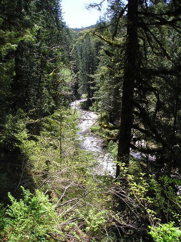
Eagle Creek from the trail
According to the FS, the official trail is 5.8 miles (which starts one mile after you hike down an abandoned road) and ends at the edge of the creek. If you want, you can ford the creek at this point and continue on the Eagle Creek Cutoff trail, which climbs very steeply uphill and away from the creek to connect with trails on the ridgeline above.
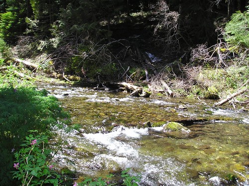
End of trail...Eagle Creek Cutoff trail begins across the creek
The Eagle Creek trail is well-maintained for the first couple of miles, then begins to get more brushy and littered with blowdown. I spent a lot of time yesterday tossing fallen limbs off the trail, but you probably wouldn't notice because there were lots more than I had time or energy to deal with.
Something you should know before you go is that to get to the trailhead you will need to cross private land owned by Longview Fiber. They have recently posted signs (dated 6/19) stating that public access is prohibited. It was not clear to me whether they were talking about off-road vehicles going off-road, or a complete ban on any access using their road. I guessed that they were referring to off-road vehicles, and since there were no barricades or a gate or anyone to ask I went my merry way to the trailhead (about 2 miles). There I ran into a FS guy from the ZigZag District, who was also surprised by the closure signs. He speculated that they might be getting ready to do some logging along that road and that there might be safety concerns. He said that he was going to check into it when he got back to the office. So before you go you might want to give the Ranger District a call to see if it's ok to use that road.
Eagle Creek from the trail
According to the FS, the official trail is 5.8 miles (which starts one mile after you hike down an abandoned road) and ends at the edge of the creek. If you want, you can ford the creek at this point and continue on the Eagle Creek Cutoff trail, which climbs very steeply uphill and away from the creek to connect with trails on the ridgeline above.
End of trail...Eagle Creek Cutoff trail begins across the creek
The Eagle Creek trail is well-maintained for the first couple of miles, then begins to get more brushy and littered with blowdown. I spent a lot of time yesterday tossing fallen limbs off the trail, but you probably wouldn't notice because there were lots more than I had time or energy to deal with.
Something you should know before you go is that to get to the trailhead you will need to cross private land owned by Longview Fiber. They have recently posted signs (dated 6/19) stating that public access is prohibited. It was not clear to me whether they were talking about off-road vehicles going off-road, or a complete ban on any access using their road. I guessed that they were referring to off-road vehicles, and since there were no barricades or a gate or anyone to ask I went my merry way to the trailhead (about 2 miles). There I ran into a FS guy from the ZigZag District, who was also surprised by the closure signs. He speculated that they might be getting ready to do some logging along that road and that there might be safety concerns. He said that he was going to check into it when he got back to the office. So before you go you might want to give the Ranger District a call to see if it's ok to use that road.
Re: The other Eagle Creek Trail
Yesterday (Friday) afternoon my wife and I headed out for a 3 day, 2 night relaxing camping trip on the Eagle Creek trail but after 4+ hours of walking around on logging roads, looking for the trail, plus it was getting dark, we decided to go home, regroup and try again another time. I did have a Topo map which was not as accurate as I would have liked it to be and it didn't help that we were in the wrong location. I would have liked to camp out there but didn't want to camp on private land, especially since we walked around 1 locked gate and passed many signs that said no camping.
I called the FS in Zig Zag before I left on Friday and talked to a person that told me to call back and let them know the status of the trail. This person had never been to the trail so he was not much help other than telling me to follow the directions on the trail description sheet. I had every intention, and still do, of documenting the trail with GPS coordinates and pictures because I have been able to find little information about this trial on the internet.
After getting home I looked on Google Maps and realized where we went wrong. We parked at the Yellow Square, just outside a blue locked gate, which was the first "Y" in the road we came to, like the directions said but it was obviously not the correct "Y". It is difficult to tell the difference between a "turn off" and a "Y". On the attached picture the red lines are the areas that I know we hiked and the blue lines is the general area of where we hiked. I am guessing that the "first 'Y'", that the FS directions where talking about is where the pink square is.
Swede, if you could give us any additional information about the trail head that would be great. Is it marked with a sign? What kind of a a trail is it (foot path, grass/dirt trail)? How far past the pink dot is it, assuming you should park at the pink dot? Is the trailhead noticeable?
Thanks for any additional information you can offer.
- Attachments
-
Re: The other Eagle Creek Trail
smflyer, I'm sorry to hear that you had trouble finding the trailhead. This would have been a perfect place to camp over this hot weekend. Apparently you didn't drive far enough once you left the pavement on Harvey Rd. The FS directions state that the trailhead is 2.4 miles from the end of the pavement. Sullivan's 100 Hikes in NW Oregon says its 2.6 miles from where you turn onto Harvey Rd from George Rd. I think both are correct, since it's about 0.3 miles to where the pavement ends on Harvey Rd.
The main thing is that there are no gates for you to go through or climb over. Once you are on the gravel road (after passing the "Public access prohibited" signs posted on the trees by the side of the road) continue past any turnoffs that are gated. When you come to a Y that is unsigned (with no gates on either fork), take the right fork, which heads downhill while the left fork either continues level or slightly uphill (I forget, sorry). I believe that this is where the pink dot is on your photo. This segment of road will take you to the trailhead. It is narrow, one lane, with trees up to the edge of the road. After 1/3 mile or so, there is a fork in the road. It would be easy to miss, as the road to the right is overgrown, while the road that you are on continues on to the left and uphill. Stop here. This is where you park. The road downhill from this point is abandoned, rocky and impassable except by dirt bikes and ATVs and the really serious 4WD types. Walk about a mile downhill from here along the old roadbed which eventually narrows into a trail. You'll pass a trail which goes off to the left to Douglas Ridge and the Wildcat Mtn trail, and a bit further you will see a FS sign on a tree on the right side of the road limiting access to hikers and horses. Where the road narrows into a trail is more or less the beginning of the Eagle Creek trail. There used to be a wilderness boundary sign on a tree, but I didn't see it this time. That's not to say that it isn't there. From this point on the trail is clearly evident all the way to the end where it crosses the creek. There is snow on the trail at many points at the upper end, but it's not hard to figure out the general direction of the trail.
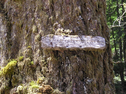
Look for this sign. It's the end of the trail.
There is a decent campsite past the end of the trail up the creek a bit from the sign in the photo, but it is still under a couple of feet of snow. There are several other nice sites at various points downstream along the trail that would make for nice camping that are snow-free.
FYI, the person that I talked to from the Zigzag Ranger District the other day was the Roads Manager, or Roads Maintenance Manager, or something like that. I think his first name was Bernie. He was there to look at the first mile of abandoned road, and said that they were considering decommissioning it so that dirt bikes and ATVs couldn't get down there. If you call the Ranger District again, you might ask for him. He was a real knowledgeable and friendly guy, and was very familiar with this trail and the country in general. He said that he lives not far away in the George area.
I hope this helps. I don't have a GPS gizmo, so I can't help you with coordinates at the trailhead. But you were pretty close yesterday, and should be able to find it the next time. It's worth a visit.
The main thing is that there are no gates for you to go through or climb over. Once you are on the gravel road (after passing the "Public access prohibited" signs posted on the trees by the side of the road) continue past any turnoffs that are gated. When you come to a Y that is unsigned (with no gates on either fork), take the right fork, which heads downhill while the left fork either continues level or slightly uphill (I forget, sorry). I believe that this is where the pink dot is on your photo. This segment of road will take you to the trailhead. It is narrow, one lane, with trees up to the edge of the road. After 1/3 mile or so, there is a fork in the road. It would be easy to miss, as the road to the right is overgrown, while the road that you are on continues on to the left and uphill. Stop here. This is where you park. The road downhill from this point is abandoned, rocky and impassable except by dirt bikes and ATVs and the really serious 4WD types. Walk about a mile downhill from here along the old roadbed which eventually narrows into a trail. You'll pass a trail which goes off to the left to Douglas Ridge and the Wildcat Mtn trail, and a bit further you will see a FS sign on a tree on the right side of the road limiting access to hikers and horses. Where the road narrows into a trail is more or less the beginning of the Eagle Creek trail. There used to be a wilderness boundary sign on a tree, but I didn't see it this time. That's not to say that it isn't there. From this point on the trail is clearly evident all the way to the end where it crosses the creek. There is snow on the trail at many points at the upper end, but it's not hard to figure out the general direction of the trail.
Look for this sign. It's the end of the trail.
There is a decent campsite past the end of the trail up the creek a bit from the sign in the photo, but it is still under a couple of feet of snow. There are several other nice sites at various points downstream along the trail that would make for nice camping that are snow-free.
FYI, the person that I talked to from the Zigzag Ranger District the other day was the Roads Manager, or Roads Maintenance Manager, or something like that. I think his first name was Bernie. He was there to look at the first mile of abandoned road, and said that they were considering decommissioning it so that dirt bikes and ATVs couldn't get down there. If you call the Ranger District again, you might ask for him. He was a real knowledgeable and friendly guy, and was very familiar with this trail and the country in general. He said that he lives not far away in the George area.
I hope this helps. I don't have a GPS gizmo, so I can't help you with coordinates at the trailhead. But you were pretty close yesterday, and should be able to find it the next time. It's worth a visit.
Last edited by Swede on July 1st, 2008, 11:10 am, edited 1 time in total.
-
Splintercat

- Posts: 8334
- Joined: May 28th, 2008, 10:03 pm
- Location: Portland
- Contact:
Re: The other Eagle Creek Trail
Shoot! Wish I would have noticed this post earlier! Swede, your directions are right on the mark. The wilderness sign is there, as well - but on the ground, leaning against a tree.
Smflyer, here's an update to your map -- you were very close to the right spot! I've drawn in the rest of the access route in green, and added a red dot where the obscure "fork" is located, and the trail begins:
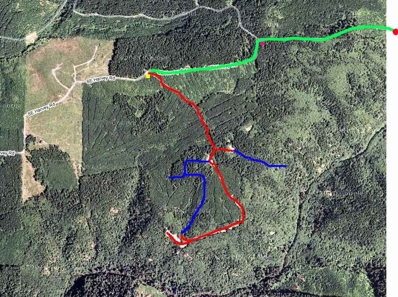
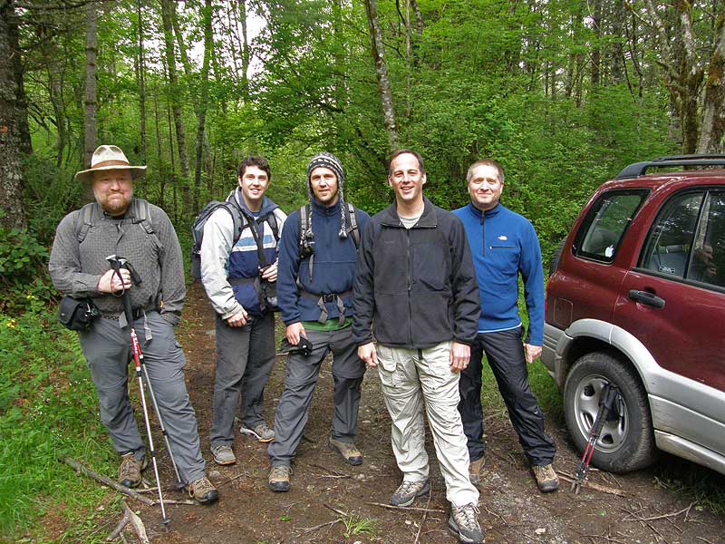
Your pink dot marks a crucial turn in the route that is not signed - go right here. The "Y" comes up abruptly along a slight curve to the left, and you'll see the trailhead spur as simply an old road dropping off to the right. The main route climbs from this point, so that's a good way to identify the spot. Here's a photo of the trailhead location (with a rather handsome cast of characters, I might add!) with the "trail" continuing on down the hill, behind the group. The uphill fork is just to the left of the big tree on the left edge of this photo:
Definitely worth the hike if you like a bit of solitude, a lot of nice forest and a pretty stream to explore. Plus, you can also bushwhack up to Chak Chak Falls if you really want to battle the brush..!
Tom
Smflyer, here's an update to your map -- you were very close to the right spot! I've drawn in the rest of the access route in green, and added a red dot where the obscure "fork" is located, and the trail begins:
Your pink dot marks a crucial turn in the route that is not signed - go right here. The "Y" comes up abruptly along a slight curve to the left, and you'll see the trailhead spur as simply an old road dropping off to the right. The main route climbs from this point, so that's a good way to identify the spot. Here's a photo of the trailhead location (with a rather handsome cast of characters, I might add!) with the "trail" continuing on down the hill, behind the group. The uphill fork is just to the left of the big tree on the left edge of this photo:
Definitely worth the hike if you like a bit of solitude, a lot of nice forest and a pretty stream to explore. Plus, you can also bushwhack up to Chak Chak Falls if you really want to battle the brush..!
Tom