Devils Rest Loop 02-Apr-2011

This forum is used to share your experiences out on the trails.
User avatar
VanMarmot
Posts: 1924
Joined: May 28th, 2008, 10:03 pm
Contact:

Devils Rest Loop 02-Apr-2011

Post by VanMarmot » April 3rd, 2011, 7:28 am

After getting chased off Kings by the weather on Friday, I resolved to hike something on Saturday regardless of the weather. Maybe this is a symptom of hiking moving from an enjoyable activity to an obsession :shock:, but no matter, I was GOING FOR A HIKE. Decided on Devils Rest via Angels Rest and Wahkeena Springs - a perennial low-altitude favorite. The weather obliged with a range of products - sun, cold air, snow, hail, sn'hail (styrofoam-like pellets), wind - everything expect actual liquid precipitation. It was actually quite nice. The weather came in squall lines heading E along the Columbia so I could watch them coming.

Image

Image

Image

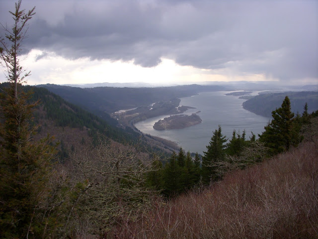
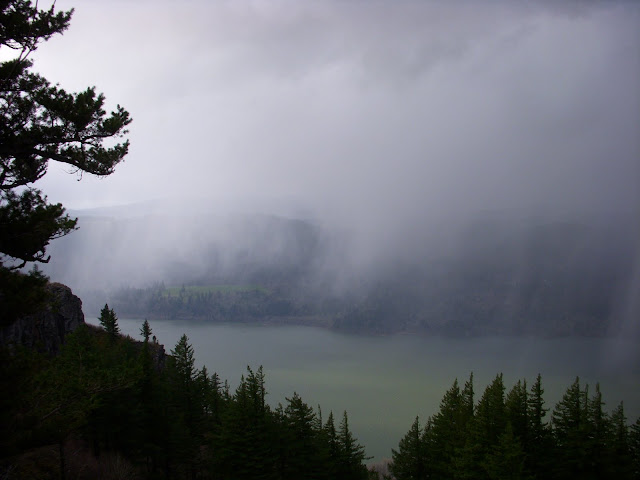
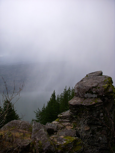
A good hike - 10.6 mi, 3290' - with the trail in good condition (particularly the Foxglove) and snow-free the whole way. I'm glad I didn't let the weather intimidate me into staying on the couch.

Image

User avatar
Crusak
Posts: 3617
Joined: August 6th, 2009, 7:33 pm
Location: Oregon

Re: Devils Rest Loop 02-Apr-2011

Post by Crusak » April 3rd, 2011, 9:40 am

Looks like an excellent loop hike!

I had no idea that connecting trails were available to hike from Devil's Rest to Angel's Rest... seriously. :shock:

I'm guessing that the trail I saw that continues past the top of Devil's Rest (heading west) is the one that leads over to Angel's Rest? If so, that answers a big question I've had for a long time (where does THAT trail go?) lol I've done Devil's Rest three times now and always wondered about that.

That's looks like a great loop, both in mileage and elevation gain. Great workout with the reward of great views.

The Foxglove - is that the connecting trail I see on the north side of the map, closer to the river?
Jim's Hikes

Solvitur Ambulando

User avatar
retired jerry
Posts: 14418
Joined: May 28th, 2008, 10:03 pm

Re: Devils Rest Loop 02-Apr-2011

Post by retired jerry » April 3rd, 2011, 9:45 am

It's described in the field guide

User avatar
VanMarmot
Posts: 1924
Joined: May 28th, 2008, 10:03 pm
Contact:

Re: Devils Rest Loop 02-Apr-2011

Post by VanMarmot » April 3rd, 2011, 12:36 pm

Crusak wrote:Looks like an excellent loop hike!

I'm guessing that the trail I saw that continues past the top of Devil's Rest (heading west) is the one that leads over to Angel's Rest? If so, that answers a big question I've had for a long time (where does THAT trail go?) lol I've done Devil's Rest three times now and always wondered about that.

The Foxglove - is that the connecting trail I see on the north side of the map, closer to the river?
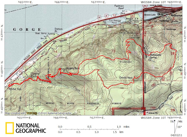
The trail heading W from the top of Devils Rest is the Foxglove which connects with the Angels Rest Trail (#415) just above Angels Rest.

You can make a longer loop by continuing on the Wahkeena Trail (#420) to Multnomah Ck, then going up the Larch Mtn Trail (#441) to where it crosses the service road to Nesika Lodge (http://www.flickr.com/photos/aymadventu ... 177288663/), then heading W on the road to where it comes within 100m of the 441 trail. You cut over and continue the loop to Devils Rest and back to Angels Rest. About 14 mi.

As Retired Jerry says, check the field guide. Also look for some of Don's posts - he occasionally includes a map of the numerous trails in the Angels/Devils Rest area that he's explored and mapped.

User avatar
Grannyhiker
Posts: 4598
Joined: May 28th, 2008, 10:03 pm
Location: Gateway to the Columbia Gorge

Re: Devils Rest Loop 02-Apr-2011

Post by Grannyhiker » April 3rd, 2011, 12:38 pm

Foxglove Way, the connecting trail between Angel's Rest and Devil's Rest, is a trail that was made by volunteers many years ago. It is still maintained by volunteers (I believe TKO was up there brushing the trail last summer), and to the best of my knowledge has not been officially recognized on Forest Service maps. You'll see it on Green Trails maps (although I haven't looked at their newest map, just out). I learned about it from the Lowe's 1980's guidebook.

The Angels/Devil's Rest loop from Wahkeena Falls is a little shorter, 8.2 miles and is described in "100 Classic Hikes in Oregon."

User avatar
Crusak
Posts: 3617
Joined: August 6th, 2009, 7:33 pm
Location: Oregon

Re: Devils Rest Loop 02-Apr-2011

Post by Crusak » April 3rd, 2011, 1:20 pm

That sounds like something I want to do on my next Gorge hike. Thanks for the info!

I didn't remember seeing 'Foxglove' on the Gorge map I have. But I also didn't think to check the Field Guide. Excellent! :)
Jim's Hikes

Solvitur Ambulando

Lurch
Posts: 1270
Joined: May 28th, 2008, 10:03 pm
Location: Aurora
Contact:

Re: Devils Rest Loop 02-Apr-2011

Post by Lurch » April 3rd, 2011, 11:43 pm

The foxgloves are published on most topo maps.

Image
Larger version

User avatar
arundodonax
Posts: 1043
Joined: August 12th, 2010, 8:02 pm

Re: Devils Rest Loop 02-Apr-2011

Post by arundodonax » April 4th, 2011, 7:42 am

Hey Lurch,

That's some pretty awesome data. Is it available anywhere?

Ron Goodwin
Posts: 132
Joined: May 28th, 2008, 10:03 pm

Re: Devils Rest Loop 02-Apr-2011

Post by Ron Goodwin » April 4th, 2011, 8:58 am

The Mazamas years ago helped keep the Foxglove (Way or Trail) open after the FS came in and plowed up the roads that it generally follows. Katie and I have tried to keep the trail cut back since the FS does not want to have another trail to maintain. Bus Gibson and I put up 10 signs at the different junctions 15 years ago and just in the last 2 years have had some removed. Replaced the one just above Angels Rest and the one just 100' from Devils Rest last year and then it was gone in October when we take a pumpkin up to continue a tradition (25 years) started years before on Devils Rest next to the elevation sign. Will replace that sign, actually two with one pointing toward Wahkeena Trail and the other toward Angels Rest. Will have to take a small ladder or something to get above where the vandal can reach.

At Multnomah Falls Visitor Center we try to encourage people to take clippers and keep the salmon berry back and to use the trail. The first few years of the Foxglove going down staight to the Wahkeena/Angels Rest Trail was used mainly by elk but enough people have used it that it is now well worn. The section that comes up directly from the Foxglove is one of the prettiest trails in the spring and summer with the arching vine maple and ground covers. Great trail to add on some distance after Angels Rest and another 800' to a total of 2,450' elevation.

User avatar
retired jerry
Posts: 14418
Joined: May 28th, 2008, 10:03 pm

Re: Devils Rest Loop 02-Apr-2011

Post by retired jerry » April 4th, 2011, 9:25 am

Thanks Ron

That is a nice trail

I definitely take my clippers or a folding saw, especially this time of year

Post Reply