This morning’s weather report suggested a period of relative dryness before the next wave of rain rolled in tonight. Well, weather forecasts for Spring in Oregon need to be taken with a grain of salt and a load of 00 buckshot, but I was willing to believe. So I headed out to do a little more exploring around Kings Mtn, particularly of Kings Jr, which I hadn’t hiked yet. I reached the Kings TH at 8am and was soon heading S on the Wilson River trail. Sunlight began streaming through the trees,
and my hopes for an unexpectedly nice day rose accordingly.
The trail crossed an old road but I kept on until the trail merged with another road about 1.5 mi from the TH. Lorain suggests a hike that makes a loop up this road and back on the Wilson River trail, but since I hadn’t been on this part of the Wilson before, I took the trail up. About 100’ past where the trail and the road merge (and just before you enter the Lester Ck drainage), a very distinct use trails heads up to Kings Jr.
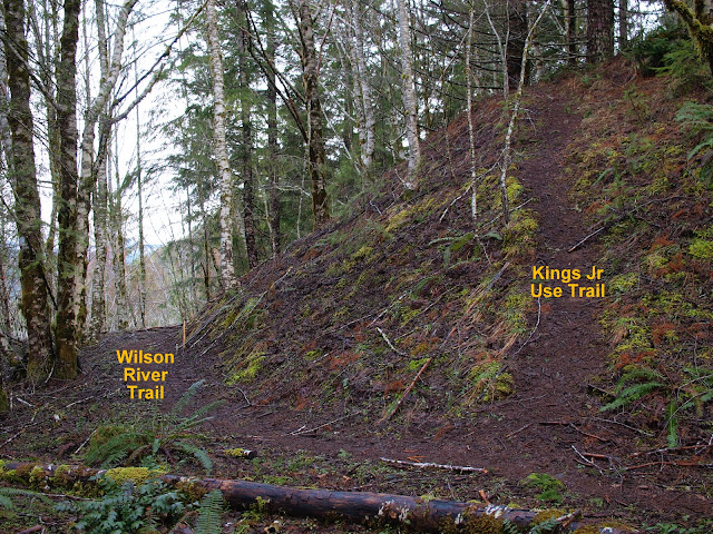
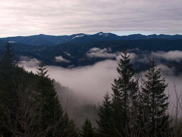
This trail, although not “official” was very distinct and easy to follow to Kings Jr. One view point presented itself and I caught a glimpse of clouds pooling in the valley but not of threatening skies.
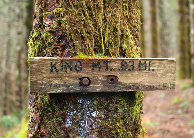
Lorain describes the path past Kings Jr as “sketchy and overgrown” but it wasn’t hard to find and follow – 0.3 mi later I arrived at the main Kings Mtn trail, just below the little wooden “.83 mi” sign.
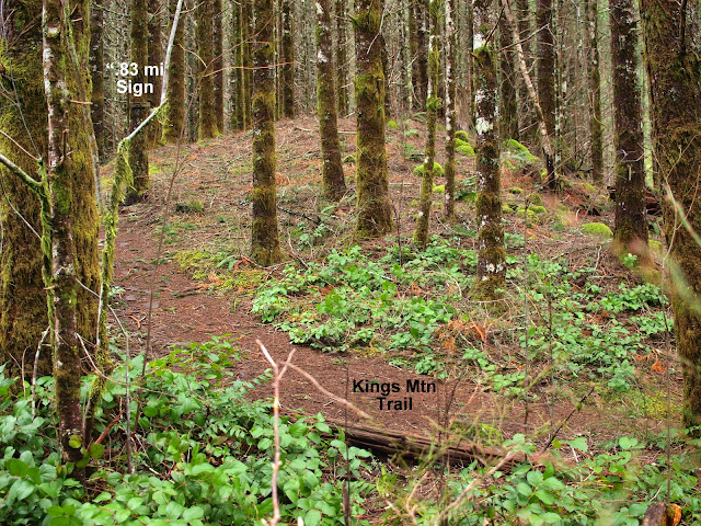
This is looking up the Kings Mtn trail from the Kings Jr trail,
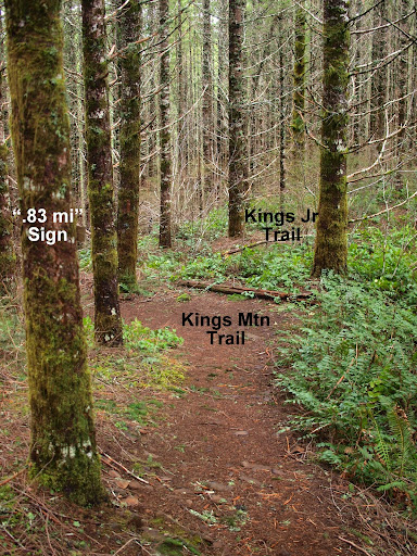
and this is looking from the Kings Mtn trail down toward the Kings Jr trail.
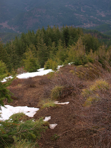
I then headed for Kings, finding that much of the snow that was there last week is now pretty much gone.
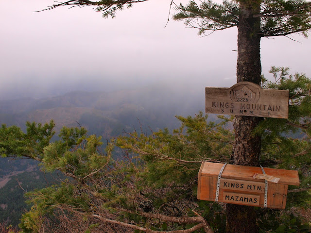
Despite the earlier sun breaks and thin clouds, by the time I reached Kings a squall line was moving in from the coast and the outdoors weren't quite so inviting anymore.
I was giving some thought to going for Elk but decided not to, given this less than welcoming weather. As I headed back to the TH, I couldn’t fail to notice that the weather was IMPROVING (or at least not getting any worse)! Ack! That’ll teach me to believe an Oregon Spring weather forecast, particularly on April Fool’s Day! But I explored some bits of new trail, reached the summit of Kings Jr, and added 5.5 mi and 2600’ to this year’s hiking log. So, overall, not bad. I'll be back...
Kings Jr Loop 01-April-2011
Re: Kings Jr Loop 01-April-2011
You did not mention the yellow and blue dots marking the trai! Also there is one more trail after the one you took.
Shoe Shine Boy Has Left The Building!
- arundodonax
- Posts: 1043
- Joined: August 12th, 2010, 8:02 pm
-
- Posts: 250
- Joined: May 28th, 2008, 10:03 pm
Re: Kings Jr Loop 01-April-2011
Great description and photos - nice alternate and it is much better shape than I expected. Soon there will be wildflowers up on the summit - yes?
- Eric Peterson
- Posts: 4097
- Joined: May 11th, 2009, 5:39 am
- Location: Oregon
- Contact:
Re: Kings Jr Loop 01-April-2011
I don't think those yellow and blue dots are there at the junction where he jetted upYou did not mention the yellow and blue dots marking the trai!
to Kings Jr. But there is some pink surveyors string hanging around that I stuck up
about a year ago...
Re: Kings Jr Loop 01-April-2011
I'm 99.9% sure based on the description and the picture. There is not another section of the trail with these trees and the fact he mentions just before the Lester creek drainageEric Peterson wrote:I don't think those yellow and blue dots are there at the junction where he jetted upYou did not mention the yellow and blue dots marking the trai!
to Kings Jr. But there is some pink surveyors string hanging around that I stuck up
about a year ago...
Shoe Shine Boy Has Left The Building!
Re: Kings Jr Loop 01-April-2011
Now 100% sure this is the bb trail:). From my postmayhem wrote:I'm 99.9% sure based on the description and the picture. There is not another section of the trail with these trees and the fact he mentions just before the Lester creek drainageEric Peterson wrote:I don't think those yellow and blue dots are there at the junction where he jetted upYou did not mention the yellow and blue dots marking the trai!
to Kings Jr. But there is some pink surveyors string hanging around that I stuck up
about a year ago...
Yep that is it
Shoe Shine Boy Has Left The Building!
Re: Kings Jr Loop 01-April-2011
I'll be the first to admit that I'm no expert on the trail systems in and around Elk/Kings - just someone always looking for a trail I have not yet trod. I used Lorain's (2nd Edition) description, along with the Mazamas map posted a while back by Eric (http://mazamas.org/pdf/maps/Elk-Kings.pdf) to find this route. Both Lorain and the Mazamas show just one route from the Wilson River trail to Kings Jr (but each shows two different routes to that point), so as soon as I came across the first obvious use trail heading up off the Wilson I took it. Never saw any blue or yellow dots but did see some remnants of Eric's surveyors tape. I was surprised (but pleased) when this trail took me expeditiously to the the Kings Mtn trail, thus making Kings available as a loop as well as an out & back.Eric Peterson wrote:I don't think those yellow and blue dots are there at the junction where he jetted upYou did not mention the yellow and blue dots marking the trai!
to Kings Jr. But there is some pink surveyors string hanging around that I stuck up
about a year ago...
Re: Kings Jr Loop 01-April-2011
This from the summit post describes the hike 2 diferent ways this being the 2nd
Alternatively, you could also stay on the well maintained Wilson River Trail and follow it to the same point. Shortly after this junction, It will be obvious you are at the base of a ridge and there will be an overabundance of blue blazes on the trees and a steep trail heading up the ridge to the right.
Follow the steep path on the right, which shoots straight up the ridge and (as of July 2009) is marked with orange flagging. This route has also been known as the Bun Buster Trail or Coronary Ridge. This path leaves the Wilson River Trail just before a tree marked BB and one marked C-ASS in blue paint. This path steeply ascends to the summit ridge, and may be difficult in wet conditions. It is approximately 0.2 miles from the trail to the summit of 'Kings Mountain Junior' (2190 ft).
Now for the pictures & Movie of the location
The first path on the Wilson River past Kings Main Trail. Sign on the tree marking the trail
Through the 2 middle trees you can see the Kings Jr Trail washout.
Now for the BB Trail & others
This is the BB trail.
This is leading to the Arrow trail Notice blue dots on the tree.
Movie
http://www.youtube.com/watch?v=NxvboCCXwSk
Shoe Shine Boy Has Left The Building!