Hatfield Trail - Angels Rest to Starvation Creek - 2010
Posted: July 25th, 2010, 9:43 am
Introduction
In June I did an overnight backpack from Angels Rest to Tanner Butte (here). My posting of this trip got a response from Splintercat, who had just posted a blog about a proposed Mark O. Hatfield Memorial Trail through the Gorge from Multnomah Falls to Starvation Creek, including some new proposed sections of trail (here). I think the Gorge, as major national scenic area, deserves its own through trail but until the Hatfield proposal becomes a reality, we’ll have to make-do with the trails we have (and the poor condition some of them are in). I then came across a posting from Beer Town Bill who had linked existing trails from Starvation Creek to Angels Rest (here). Inspired by both Splintercat and Beer Town, and having started down the path of a trans-Gorge hike with my efforts in June, I decided to go back and finish one. I’ve woven together the start in June and the finish this Saturday to portray this hike as a 3-night backpack. Starting at Angels Rest let me ease into this hike (OK, I couldn’t face hiking up Defiance with a full pack and water) and is a less insanely crowded TH than Multnomah Falls. Going over Defiance on the last day let me stand on the “the summit of the Gorge”, before enduring the knee-busting drop down to the Starvation Creek TH. By my count, the total distance was 58.7 mi (not including the going out and coming back in segment).
DAY 1 (Angels Rest to Neismith Spur Road – 16.4 mi)
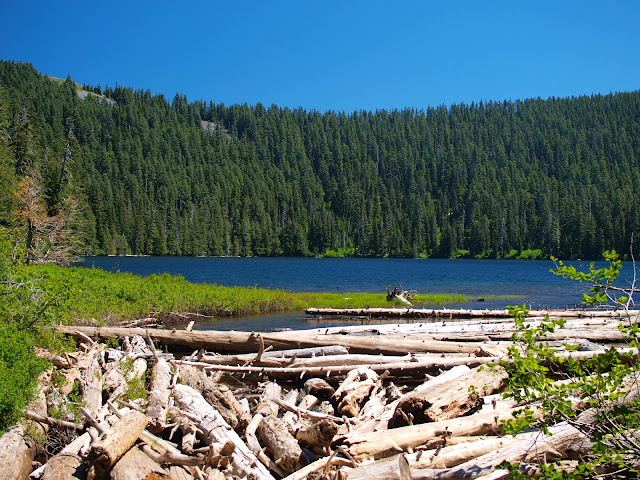
In June, I went from Angels Rest to where the Moffett Creek trail crosses Talapus Road and ended up camping on the road after failing to find Van Ahn Rim Camp. In hindsight, it would have been better to have camped on the middle fork of Horsetail Creek (small site with old fire ring) or on or near the spur road (as a solo backpacker I don’t need much room). Much of this segment of the hike is through the trees with limited views but there is a great view off the Horsetail Creek trail and another off the Moffett Trail along the Van Ahn Rim.
DAY 2 (Neismith Spur Road to Big Cedar Springs Camp – 17.1 mi)
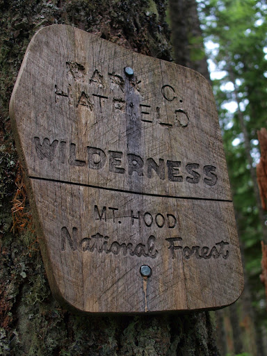
In June, I went from the Talapus Road down the Moffett Trail, along the Tanner Creek Trail, and then up the Tanner Cutoff Trail to the Tanner Butte Trail – then took the Tanner Butte Trail out {In retrospect, the drop in to and climb out of Tanner Creek canyon was the hardest and most demanding part of this entire hike due to poorly maintained trails and the difficulty of crossing the creek}. Last Thursday, I hiked back to the junction of the Tanner Cutoff and Tanner Butte Trails and the trans-Gorge hiked continued from there. By now, I was well into the Hatfield Wilderness.
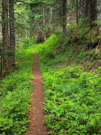
Much of the Tanner Butte trail past Dublin Lake is actually a reverting roadbed, some parts of which were clear,
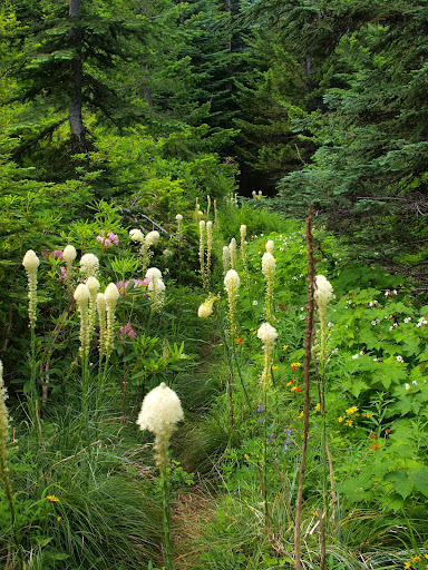
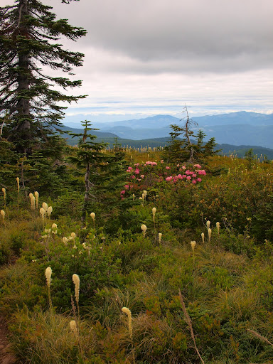
and some sections, although brushy, were festooned with beargrass and other colorful flowers.
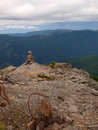
The weather on Thursday was great for hiking – overcast and cool with a light breeze – but not so good for the view from atop Tanner Butte. Hood was decapitated by clouds,
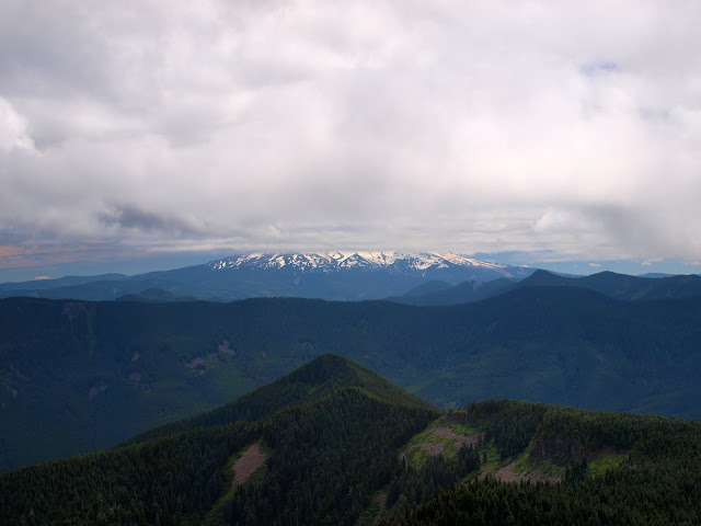
but I could see from Tanner across to Defiance, roughly 10 air miles away.
Flowers also adorned the summit of the butte – even the rhodies were still blooming.
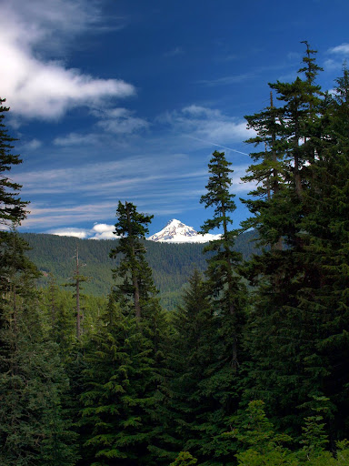
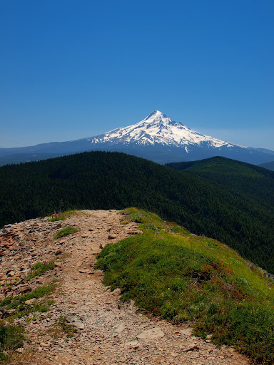
From Tanner Butte, I headed down the Eagle-Tanner trail to Big Cedar Springs camp. Enroute, I attempted to find Tanner Spring, but the trail was so overgrown and eroded that I gave up before finding any water. The Eagle-Tanner trail above Big Cedar is not in good condition and I had to pay attention for sudden turns and twists. As I was descending, the clouds started to clear and Hood came fully into view.
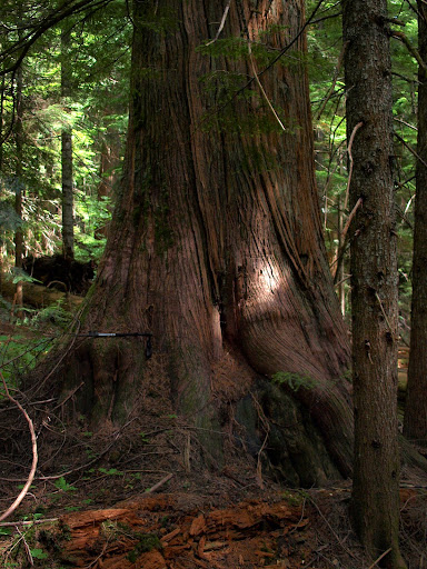
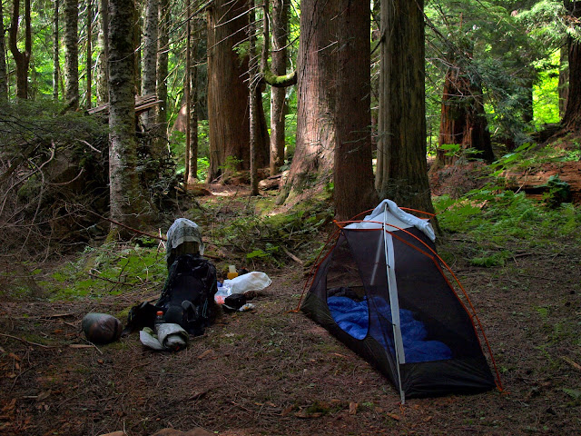
The springs were not gushing, but there was enough water for camping. The cedars really are BIG – my collapsed trekking pole is about 24”, making this cedar about 8’ DBH.
Camp was comfortable and spacious. There were no mosquitoes! And so to bed...
DAY 3 (Big Cedar Springs Camp to Rainy Lake - 16.4 mi)
Temperatures were supposed to start rising so I got an early start to take advantage of the cool gloom of the Eagle-Tanner trail.
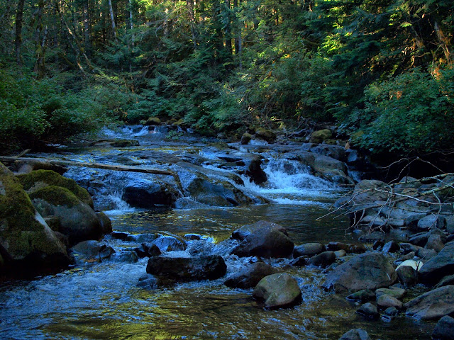
Crossing Eagle Creek was no problem (there’s also a good campsite at this crossing).
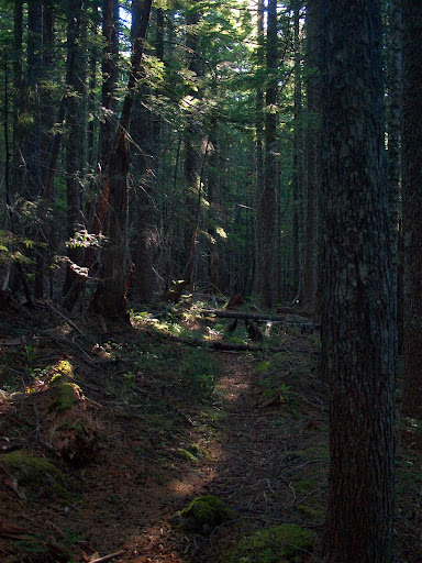
When I reached the Eagle Creek trail proper, it was like stepping off a cart-track of a trail onto a superhighway. This upper section of the Eagle is wide and well groomed and there were many signs of recent maintenance.
It seems to have become an alternative to the PCT for going from Cascade Locks to Whatum Lake and looks like it’s now getting PCT-level maintenance. I followed its leisurely grade up to Whatum Lake and meetings with several backpackers (I’d seen no one the day before).
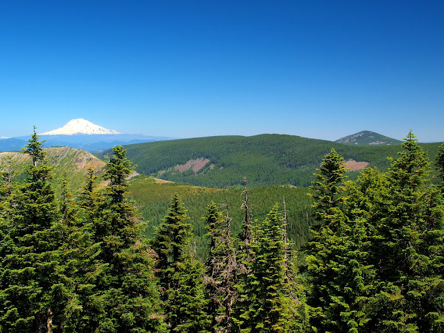
I added Chinidere Mountain as an option, so as to get views of Hood,
and Mounts Defiance and Adams (Adams is the white one).
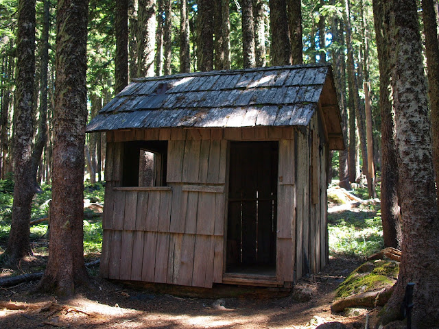
I then took the Rainy-Whatum Trail to Rainy Lake – enroute I came upon this little cabin at the junction of the Herman Creek Cutoff and Gorton Creek Trails. There has got to be some story about why it's here.
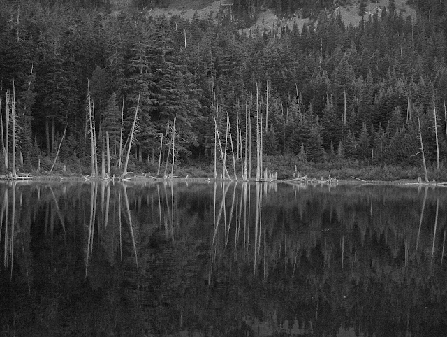
There were people car camping at the Rainy Lake TH campground but I had the backpacker sites near the lake all to myself. It had been a warm day but by nightfall temperatures were very comfortable. There were a few pesky mosquitoes around but many fewer than I would have expected. As night fell, spectral reflections of dead trees were cast on to the lake.
DAY 4 (Rainy Lake to Starvation Creek TH – 8.8 mi)
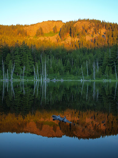
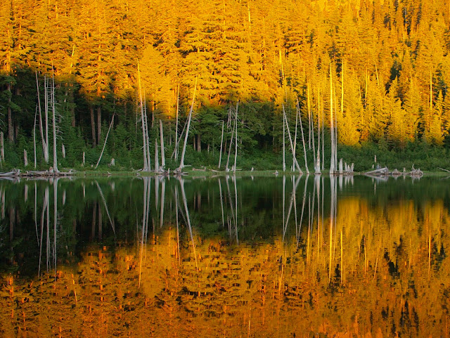
Today was supposed to be even warmer, so another early start. The lake bowl faces east, so first light brought a host of cheery colors to the lake and its surrounds.
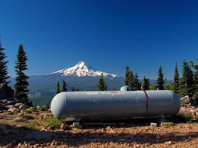
I went past North Lake, then headed up to Mt. Defiance. Every time I climb Defiance, I’m struck by the juxtaposition of Hood in one direction and a collection of comm towers in the other. My goal was to capture these two extremes in one shot (I call it: “King of the Hill” with propane, and propane accessories...).
After that it was down past Warren Lake to the Starvation Lake TH, where the loved one was waiting for me. This was planned as a short day, so I was down before noon (which was good because now it was HOT!), and we were able to stop at the Char Burger for sustenance before heading back to Portland.
Even in two parts, this was an amazing hike that gave me a glimpse of parts of the Mark O. Hatfield Wilderness and the Scenic Area that I would not have gotten otherwise - everyone who loves the Gorge should try to fit this hike into their plans. I’m really afraid that if more of us don’t do so that some of the key trails – like the Moffett and upper Eagle-Tanner – will deteriorate to the point where the trip will not be readily accessible to most backpackers. That would be a terrible loss and one that I hope won’t be allowed to happen.
In June I did an overnight backpack from Angels Rest to Tanner Butte (here). My posting of this trip got a response from Splintercat, who had just posted a blog about a proposed Mark O. Hatfield Memorial Trail through the Gorge from Multnomah Falls to Starvation Creek, including some new proposed sections of trail (here). I think the Gorge, as major national scenic area, deserves its own through trail but until the Hatfield proposal becomes a reality, we’ll have to make-do with the trails we have (and the poor condition some of them are in). I then came across a posting from Beer Town Bill who had linked existing trails from Starvation Creek to Angels Rest (here). Inspired by both Splintercat and Beer Town, and having started down the path of a trans-Gorge hike with my efforts in June, I decided to go back and finish one. I’ve woven together the start in June and the finish this Saturday to portray this hike as a 3-night backpack. Starting at Angels Rest let me ease into this hike (OK, I couldn’t face hiking up Defiance with a full pack and water) and is a less insanely crowded TH than Multnomah Falls. Going over Defiance on the last day let me stand on the “the summit of the Gorge”, before enduring the knee-busting drop down to the Starvation Creek TH. By my count, the total distance was 58.7 mi (not including the going out and coming back in segment).
DAY 1 (Angels Rest to Neismith Spur Road – 16.4 mi)
In June, I went from Angels Rest to where the Moffett Creek trail crosses Talapus Road and ended up camping on the road after failing to find Van Ahn Rim Camp. In hindsight, it would have been better to have camped on the middle fork of Horsetail Creek (small site with old fire ring) or on or near the spur road (as a solo backpacker I don’t need much room). Much of this segment of the hike is through the trees with limited views but there is a great view off the Horsetail Creek trail and another off the Moffett Trail along the Van Ahn Rim.
DAY 2 (Neismith Spur Road to Big Cedar Springs Camp – 17.1 mi)
In June, I went from the Talapus Road down the Moffett Trail, along the Tanner Creek Trail, and then up the Tanner Cutoff Trail to the Tanner Butte Trail – then took the Tanner Butte Trail out {In retrospect, the drop in to and climb out of Tanner Creek canyon was the hardest and most demanding part of this entire hike due to poorly maintained trails and the difficulty of crossing the creek}. Last Thursday, I hiked back to the junction of the Tanner Cutoff and Tanner Butte Trails and the trans-Gorge hiked continued from there. By now, I was well into the Hatfield Wilderness.
Much of the Tanner Butte trail past Dublin Lake is actually a reverting roadbed, some parts of which were clear,
and some sections, although brushy, were festooned with beargrass and other colorful flowers.
The weather on Thursday was great for hiking – overcast and cool with a light breeze – but not so good for the view from atop Tanner Butte. Hood was decapitated by clouds,
but I could see from Tanner across to Defiance, roughly 10 air miles away.
Flowers also adorned the summit of the butte – even the rhodies were still blooming.
From Tanner Butte, I headed down the Eagle-Tanner trail to Big Cedar Springs camp. Enroute, I attempted to find Tanner Spring, but the trail was so overgrown and eroded that I gave up before finding any water. The Eagle-Tanner trail above Big Cedar is not in good condition and I had to pay attention for sudden turns and twists. As I was descending, the clouds started to clear and Hood came fully into view.
The springs were not gushing, but there was enough water for camping. The cedars really are BIG – my collapsed trekking pole is about 24”, making this cedar about 8’ DBH.
Camp was comfortable and spacious. There were no mosquitoes! And so to bed...
DAY 3 (Big Cedar Springs Camp to Rainy Lake - 16.4 mi)
Temperatures were supposed to start rising so I got an early start to take advantage of the cool gloom of the Eagle-Tanner trail.
Crossing Eagle Creek was no problem (there’s also a good campsite at this crossing).
When I reached the Eagle Creek trail proper, it was like stepping off a cart-track of a trail onto a superhighway. This upper section of the Eagle is wide and well groomed and there were many signs of recent maintenance.
It seems to have become an alternative to the PCT for going from Cascade Locks to Whatum Lake and looks like it’s now getting PCT-level maintenance. I followed its leisurely grade up to Whatum Lake and meetings with several backpackers (I’d seen no one the day before).
I added Chinidere Mountain as an option, so as to get views of Hood,
and Mounts Defiance and Adams (Adams is the white one).
I then took the Rainy-Whatum Trail to Rainy Lake – enroute I came upon this little cabin at the junction of the Herman Creek Cutoff and Gorton Creek Trails. There has got to be some story about why it's here.
There were people car camping at the Rainy Lake TH campground but I had the backpacker sites near the lake all to myself. It had been a warm day but by nightfall temperatures were very comfortable. There were a few pesky mosquitoes around but many fewer than I would have expected. As night fell, spectral reflections of dead trees were cast on to the lake.
DAY 4 (Rainy Lake to Starvation Creek TH – 8.8 mi)
Today was supposed to be even warmer, so another early start. The lake bowl faces east, so first light brought a host of cheery colors to the lake and its surrounds.
I went past North Lake, then headed up to Mt. Defiance. Every time I climb Defiance, I’m struck by the juxtaposition of Hood in one direction and a collection of comm towers in the other. My goal was to capture these two extremes in one shot (I call it: “King of the Hill” with propane, and propane accessories...).
After that it was down past Warren Lake to the Starvation Lake TH, where the loved one was waiting for me. This was planned as a short day, so I was down before noon (which was good because now it was HOT!), and we were able to stop at the Char Burger for sustenance before heading back to Portland.
Even in two parts, this was an amazing hike that gave me a glimpse of parts of the Mark O. Hatfield Wilderness and the Scenic Area that I would not have gotten otherwise - everyone who loves the Gorge should try to fit this hike into their plans. I’m really afraid that if more of us don’t do so that some of the key trails – like the Moffett and upper Eagle-Tanner – will deteriorate to the point where the trip will not be readily accessible to most backpackers. That would be a terrible loss and one that I hope won’t be allowed to happen.