Scout Camp Trail - 4/4

This forum is used to share your experiences out on the trails.
Post Reply
User avatar
awildman
Posts: 918
Joined: June 6th, 2009, 5:20 pm
Location: Portland

Scout Camp Trail - 4/4

Post by awildman » April 5th, 2010, 8:00 pm

I only know about this trail because I have some friends who are looking at property in the Crooked River Ranch development outside of Terrebonne and we stumbled upon the trailhead. There's not much in the way of hiking in the area outside of Smith Rock, but this little trail is a gem. I would highly recommend it if you find yourself at Smith for the weekend or traveling through from Bend/Redmond and want to get in a little up-down. It's short - about 3 miles - but very scenic and interesting. If there was a way to cross the Deschutes River, you could link up to the Alder Springs Trail, which is mentioned in Sullivan's green book, "100 Hikes in the Central Oregon Cascades".

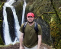
Apologies for the muddy photos and over-saturization. The weather was craptastic on Sunday, even east of the mountains. Still, it's a beautiful and colorful place - even on the grayest and windiest of days.
Scout Camp Trail_01.JPG
trail sign - laminated and stapled
Scout Camp Trail_02.JPG
Really? The MOST difficult trail?
Scout Camp Trail_03.JPG
early wildflowers
Scout Camp Trail_04.JPG
some sort of a lily?
Scout Camp Trail_06.JPG
paintbrush and desert parsley
Scout Camp Trail_05.JPG
Deschutes River canyon
Scout Camp Trail_07.JPG
the trail - counterclockwise
Scout Camp Trail_08.JPG
Whychus Creek, I think.
Scout Camp Trail_09.JPG
rock lichen
Scout Camp Trail_11.JPG
colorful and interesting geology
Scout Camp Trail_12.JPG
down next to the river
Scout Camp Trail_13.JPG
a little arch
Scout Camp Trail_15.JPG
Deschutes River canyon
Scout Camp Trail_16.JPG
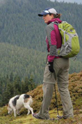
Oscar enjoys his view
Rambling on at Allison Outside

cfm
Posts: 1097
Joined: June 18th, 2008, 6:49 am

Re: Scout Camp Trail - 4/4

Post by cfm » April 5th, 2010, 8:39 pm

Well hey how about that. I was across the river a few weeks ago and saw people hiking around the base of Rainbow Rock, which is the big colorful castle formation at the confluence. You captured nice details on the layers of that formation. It was very mesmerizing seeing it come into view as we descended down Whychus. Your lily is called a sand lily.

User avatar
AlexanderSupertramp
Posts: 1447
Joined: May 28th, 2008, 10:02 pm

Re: Scout Camp Trail - 4/4

Post by AlexanderSupertramp » April 5th, 2010, 9:29 pm

Great report and gorgeous pictures! I wasn't aware of this trail but I'm glad I am now.

Thanks,

Adam

User avatar
Charley
Posts: 1839
Joined: May 28th, 2008, 10:03 pm
Location: Milwaukie

Re: Scout Camp Trail - 4/4

Post by Charley » April 5th, 2010, 9:44 pm

Hey! Nice find, and thanks for not keeping it a secret. Is that BLM land down there? And was there a ford of Wychus Creek within sight? I ask because the grove of ponderosa in your photo looks very enticing for camping. I wonder about backpacking that area.
Charley
Believe it or not, I barely ever ride a mountain bike.

User avatar
romann
Posts: 2417
Joined: May 28th, 2008, 10:03 pm
Location: Vancouver, WA

Re: Scout Camp Trail - 4/4

Post by romann » April 5th, 2010, 10:42 pm

It's really a gem, I love the photos! Is it adjacent to Smith Rocks? On what road do you get there? Is the trail 3 miles out and back or one way? Maybe I'll get a chance next spring, now I'm too busy until late May when all rattlers in high desert should be out. It's surprising you had no snow, I think this area is well above 2000 feet.

User avatar
awildman
Posts: 918
Joined: June 6th, 2009, 5:20 pm
Location: Portland

Re: Scout Camp Trail - 4/4

Post by awildman » April 6th, 2010, 7:30 am

Charley wrote:Is that BLM land down there? And was there a ford of Wychus Creek within sight? I ask because the grove of ponderosa in your photo looks very enticing for camping.
It is BLM land.

A ford is a little complicated because the photo of Whychus Creek is really a confluence of the Deschutes and Whychus (nee Squaw) Creek. What you can't see in the photo is the curve of the Dechutes. I was looking at maps last night and noticed that the Whychus drainage starts up in the Three Sisters high country, so I'm not sure what its levels do throughout the season. Fording across the Deschutes in this location would be very, very, very challenging - if not impossible - without a structure or super powers. But I do think that the ponderosa stand would make a nice little camp. You can access it from the Alder Springs trail on the other side of the canyon. CFM might have more info.
Rambling on at Allison Outside

User avatar
awildman
Posts: 918
Joined: June 6th, 2009, 5:20 pm
Location: Portland

Re: Scout Camp Trail - 4/4

Post by awildman » April 6th, 2010, 9:10 am

romann wrote:Is it adjacent to Smith Rocks?
No, it's on the west side of US 97, between the Crooked River canyon and the Deschutes River canyon.
On what road do you get there?
That is a good question, my friend. I was a passenger and we were looking at properties all over the development so I didn't have a good sense of where we were. But here's the location of the trailhead and how Google Maps would get there.
Is the trail 3 miles out and back or one way?
It's a loop. You drop about 700' from the rim to the river and then climb back up again.
Rambling on at Allison Outside

cfm
Posts: 1097
Joined: June 18th, 2008, 6:49 am

Re: Scout Camp Trail - 4/4

Post by cfm » April 6th, 2010, 3:40 pm

Indeed Charley, there are several very inviting campgrounds along Whychus Creek below Alder Springs. Of course, you have to cross the creek. We brought extra shoes, but if you didn't there is a supply!

Image

Here is the campsite at Aspen Springs. The spring flows out of the ground and into the creek here. I refilled my water bottle from it.

Image

Here is the view across the Deschutes of the Scout Camp Trail area from the campsite at the confluence:

Image

Holman Road which leads to the Alder Springs trailhead is now open. It closes from December through March. We accessed the area from Squaw Flat Road.

User avatar
BrianEdwards
Posts: 2405
Joined: February 2nd, 2010, 1:32 am
Location: Oregon City, OR
Contact:

Re: Scout Camp Trail - 4/4

Post by BrianEdwards » April 7th, 2010, 12:12 pm

That rock formation with the arch is impressive!
Clackamas River Waterfall Project - 95 Documented, 18 to go.

User avatar
funhog
Posts: 288
Joined: May 28th, 2008, 10:03 pm

Re: Scout Camp Trail - 4/4

Post by funhog » April 8th, 2010, 5:38 am

We have a place out at CRR and I have hiked the area quite a lot. The entire Ranch is surrounded by public land, much of it with trails. I was amazed when this new trail was opened last year by the BLM, along with another one at the end of Horney Hollow (!)

Crossing the Deschutes after the confluence with Whychus Creek would be beyond foolhardy. The river rages there most of the year. You can ford the Deschutes upstream after mid-April when the irrigation district begins drawing down the water for irrigation but reaching the confluence would be a bushwack at best and possibly more like canyoneering in places.

The Google map directions are really dumb. Once on the Ranch, follow signs to the Firehouse. Just before the Firehouse turn right on N Rim/Panorama. Go a couple of miles to N Meadow and turn left. Go to Scout Camp Trail where you turn right and go to the Trailhead at the end of the road. You can usually get a Ranch map at the kiosk down by the tennis courts adjacent to the golf course (follow signs) or at the real estate office in the same area.

I have backpacked down the Alder Springs trail. You can find directions in the Central Cascades Sullivan book 2nd edition. Fording the stream during summer is a piece of cake. You can find lots of campsites right after the ford or go on down to the confluence, a more limited area. This area is at HIGH risk for fires and I believe they are forbidden, in spite of the stupid fire rings you are likely to find.

Post Reply